

View Information About HSR Ratings
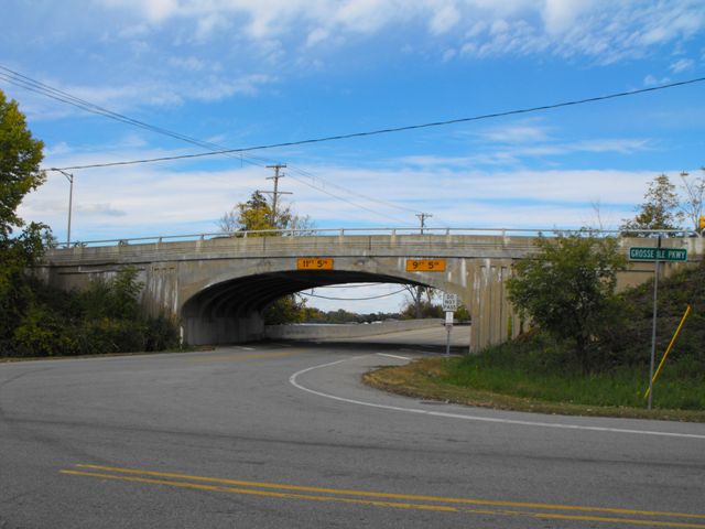
This bridge is extremely significant because it is an example of Wayne County's rare cantilevered concrete arch bridges. These unusual bridges defy attempts at classification, and have also been described as curved t-beam bridges instead of arch bridges, because the arch is actually formed of individual beams rather than a solid arch structure as is normally the case with closed spandrel arch bridges. Wayne County built a number of these bridges across the county, and several examples remain today. A cantilevered concrete arch does not function like a traditional arch. Traditional arch bridges require the arch to be a complete and connected arch to function. This arch bridge does not function in that way. Each half of each arch spans is a cantilever arm that is structurally independent from the other half of the arch in that span. These cantilever arms support a suspended span which is essentially a reinforced concrete slab in the center of the bridge. Looking closely at this bridge, two seams are visible on the side of the arch, marking where the cantilever arms end and the suspended span begins.
This bridge had its original railings destroyed in 1995, resulting in a loss of historic integrity. Suggested future preservation work would be to replace the current ugly standard MDOT barrier and employ one of the several AASHTO approved concrete balustrade guardrails which feature attractive designs more similar to the original bridge railings.
![]()
![]()
![]()

![]()
This historic bridge has been demolished. This map is shown for reference purposes only.
Coordinates (Latitude, Longitude):
Search For Additional Bridge Listings:
Bridgehunter.com: View listed bridges within 0.5 miles (0.8 kilometers) of this bridge.
Bridgehunter.com: View listed bridges within 10 miles (16 kilometers) of this bridge.
Additional Maps:
Google Streetview (If Available)
GeoHack (Additional Links and Coordinates)
Apple Maps (Via DuckDuckGo Search)
Apple Maps (Apple devices only)
Android: Open Location In Your Map or GPS App
Flickr Gallery (Find Nearby Photos)
Wikimedia Commons (Find Nearby Photos)
Directions Via Sygic For Android
Directions Via Sygic For iOS and Android Dolphin Browser
USGS National Map (United States Only)
Historical USGS Topo Maps (United States Only)
Historic Aerials (United States Only)
CalTopo Maps (United States Only)

© Copyright 2003-2024, HistoricBridges.org. All Rights Reserved. Disclaimer: HistoricBridges.org is a volunteer group of private citizens. HistoricBridges.org is NOT a government agency, does not represent or work with any governmental agencies, nor is it in any way associated with any government agency or any non-profit organization. While we strive for accuracy in our factual content, HistoricBridges.org offers no guarantee of accuracy. Information is provided "as is" without warranty of any kind, either expressed or implied. Information could include technical inaccuracies or errors of omission. Opinions and commentary are the opinions of the respective HistoricBridges.org member who made them and do not necessarily represent the views of anyone else, including any outside photographers whose images may appear on the page in which the commentary appears. HistoricBridges.org does not bear any responsibility for any consequences resulting from the use of this or any other HistoricBridges.org information. Owners and users of bridges have the responsibility of correctly following all applicable laws, rules, and regulations, regardless of any HistoricBridges.org information.
![]()