

View Information About HSR Ratings
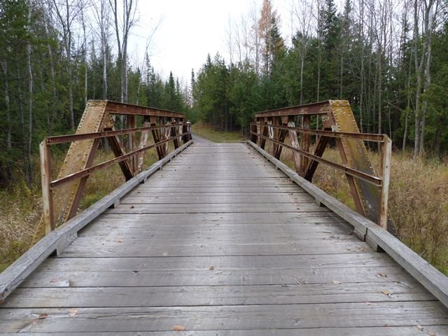
This bridge is one of five historic metal truss bridges that were saved from demolition when the Sweetgrass Golf Club acquired these former highway bridges and moved them onto the Sweetgrass Golf Course, where they are both functional and beautiful parts of the large golf course. This bridge is located on a pathway that runs between Hole 1 and Hole 2 on the course. Unlike some of the other bridges that sit out in the open on the course, this bridge sits in a less open, somewhat wooded setting on the edge of the course property. The bridge is not far from a nearby highway. The bridge has reportedly been used as a backdrop for wedding photographs in this location.
This bridge is a riveted Warren pony truss that has trusses which show no signs of alterations from its original design.
Bolts on the top chord splice suggest that all riveting for this bridge was completed in the shop, with the bridge shipped to its original construction site with its two truss each in two sections that were bolted together in the field. The use of bolts would have avoided the need for field riveting equipment at the construction site. This bridge's use of bolts is different and less extensive than with the Old US-41 Bridge where the bridge appears to have been shipped with individual truss members all separated, those members all being bolted together at the gusset plates in the field.
![]()
![]()
![]()
This bridge is located on a golf course and is private property, open to golf course users only.
Coordinates (Latitude, Longitude):
Search For Additional Bridge Listings:
Bridgehunter.com: View listed bridges within 0.5 miles (0.8 kilometers) of this bridge.
Bridgehunter.com: View listed bridges within 10 miles (16 kilometers) of this bridge.
Additional Maps:
Google Streetview (If Available)
GeoHack (Additional Links and Coordinates)
Apple Maps (Via DuckDuckGo Search)
Apple Maps (Apple devices only)
Android: Open Location In Your Map or GPS App
Flickr Gallery (Find Nearby Photos)
Wikimedia Commons (Find Nearby Photos)
Directions Via Sygic For Android
Directions Via Sygic For iOS and Android Dolphin Browser
USGS National Map (United States Only)
Historical USGS Topo Maps (United States Only)
Historic Aerials (United States Only)
CalTopo Maps (United States Only)

© Copyright 2003-2024, HistoricBridges.org. All Rights Reserved. Disclaimer: HistoricBridges.org is a volunteer group of private citizens. HistoricBridges.org is NOT a government agency, does not represent or work with any governmental agencies, nor is it in any way associated with any government agency or any non-profit organization. While we strive for accuracy in our factual content, HistoricBridges.org offers no guarantee of accuracy. Information is provided "as is" without warranty of any kind, either expressed or implied. Information could include technical inaccuracies or errors of omission. Opinions and commentary are the opinions of the respective HistoricBridges.org member who made them and do not necessarily represent the views of anyone else, including any outside photographers whose images may appear on the page in which the commentary appears. HistoricBridges.org does not bear any responsibility for any consequences resulting from the use of this or any other HistoricBridges.org information. Owners and users of bridges have the responsibility of correctly following all applicable laws, rules, and regulations, regardless of any HistoricBridges.org information.
![]()