

View Information About HSR Ratings
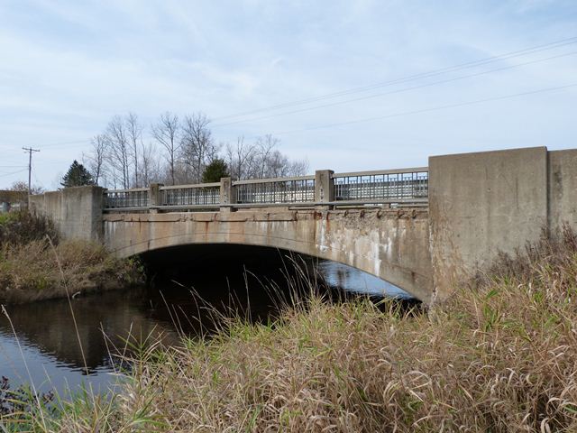
To the casual observer, this bridge has every appearance of being something unusual: a 1950s concrete arch bridge built by the Michigan State Highway Department (MSHD). It has the railings, abutment detailing, and plaques of a 1950s MSHD bridge. However, concrete arch bridges were not common in the 1950s, especially for spans as small as this. The reality is that this is actually a concrete arch bridge built in 1914. In 1952-1953, the 1914 bridge was widened. Widening the bridge required substantial reconstruction of the abutments, and as a result the outer walls of the abutments ended up with 1950s style stepped abutment wing walls Widening the bridge also required removal of original railings. As a result, new railings, typical 1950s MSHD Type R4 ornamental railings were added to the bridge. Finally, the MSHD added standard bronze bridge plaques to the bridge. However, they used the same text on the plaques as they would for a new bridge, so the plaques make it look like the bridge was first built in 1952, which is incorrect. The National Bridge Inventory reports the accurate 1914 construction date. Physical evidence of this bridge's 1914 parts is visible when looking under the bridge. Under the bridge, the change in the pattern left behind by the wooden planks from the forms used to pour the concrete indicates where the old and new portions of the bridge are located. The old portion is right in the center.
As such, this bridge is interesting because of its story. Also, since MSHD was still using applying noteworthy aesthetics to its bridges in the 1950s, the bridge's arch combined with the 1950s aesthetics still results in an attractive bridge that is far more interesting than any modern bridge could ever hope to be.
Note that the contractor HistoricBridges.org has listed for this bridge did the 1952 rehabilitation work. It is not known who built the 1914 portion of the bridge.
![]()
![]()
![]()
Coordinates (Latitude, Longitude):
Search For Additional Bridge Listings:
Bridgehunter.com: View listed bridges within 0.5 miles (0.8 kilometers) of this bridge.
Bridgehunter.com: View listed bridges within 10 miles (16 kilometers) of this bridge.
Additional Maps:
Google Streetview (If Available)
GeoHack (Additional Links and Coordinates)
Apple Maps (Via DuckDuckGo Search)
Apple Maps (Apple devices only)
Android: Open Location In Your Map or GPS App
Flickr Gallery (Find Nearby Photos)
Wikimedia Commons (Find Nearby Photos)
Directions Via Sygic For Android
Directions Via Sygic For iOS and Android Dolphin Browser
USGS National Map (United States Only)
Historical USGS Topo Maps (United States Only)
Historic Aerials (United States Only)
CalTopo Maps (United States Only)

© Copyright 2003-2024, HistoricBridges.org. All Rights Reserved. Disclaimer: HistoricBridges.org is a volunteer group of private citizens. HistoricBridges.org is NOT a government agency, does not represent or work with any governmental agencies, nor is it in any way associated with any government agency or any non-profit organization. While we strive for accuracy in our factual content, HistoricBridges.org offers no guarantee of accuracy. Information is provided "as is" without warranty of any kind, either expressed or implied. Information could include technical inaccuracies or errors of omission. Opinions and commentary are the opinions of the respective HistoricBridges.org member who made them and do not necessarily represent the views of anyone else, including any outside photographers whose images may appear on the page in which the commentary appears. HistoricBridges.org does not bear any responsibility for any consequences resulting from the use of this or any other HistoricBridges.org information. Owners and users of bridges have the responsibility of correctly following all applicable laws, rules, and regulations, regardless of any HistoricBridges.org information.
![]()