


View Information About HSR Ratings

This bridge is a rare and excellent example of a steel three-hinged arch bridge. The bridge also has a series of deck plate girder approach spans which include attractive steel bents. Geometric intricacy of the bridge is found in the numerous built-up beams with lattice and v-lacing. Although ugly cyclone fences have been added to the bridge, original ornamental lattice railings remain on the bridge as well. This bridge has been rehabilitated for light vehicular traffic, following a period in which the bridge had deteriorated to the point that it was closed to traffic. Some bolts are visible on the bridge in areas of alteration, but most alterations appear to be otherwise sympathetic to the original design. The bridge was erected by on-site contractors Alexander Y. Bayne and William S. Hewett of Minneapolis, who also acted as designing engineers for the bridge. The steel parts of the bridge were fabricated by Minneapolis Steel and Machinery Company of Minneapolis. Both Inland and Illinois steel brands were found on original bridge steel, indicating where the actual steel itself was manufactured.
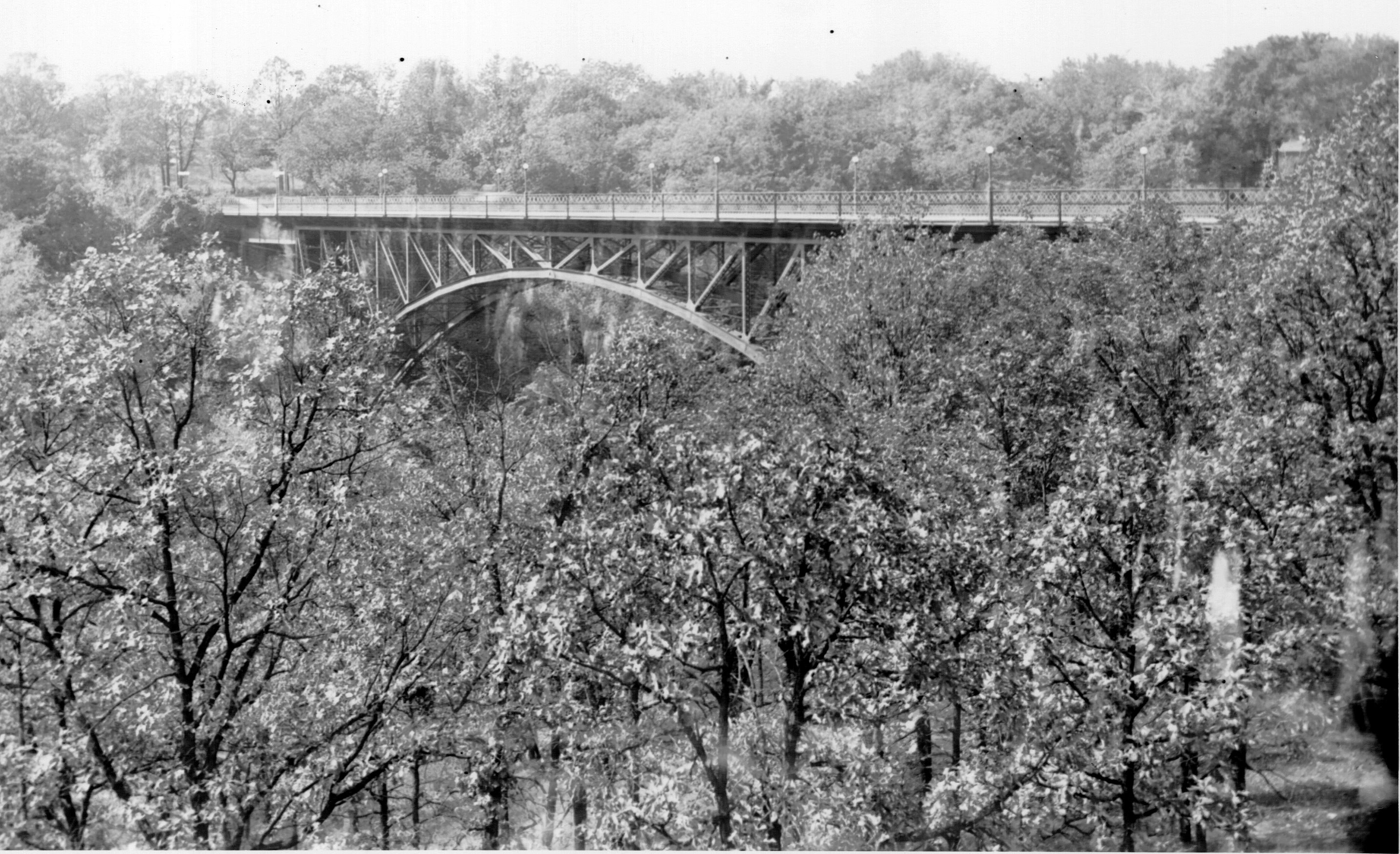
This bridge is extremely hard to photograph due to all the trees around it.
The 26th Annual Reports of the Various City Officers of the City of Minneapolis included a brief description of the bridge as follows.
The new Soldiers' Home bridge, built by the trustees of the Home at a cost of $40,000, was completed in September. It is a very handsome steel structure, spanning the glen in one beautiful, graceful arch 320 feet long,
the abutments of the span being about halfway up the steep banks on both sides. In summer the two ends of the bridge with their perpendicular supports are almost entirely hidden by the foliage of the trees on the wooded banks, and only the
arch-supported part of the bridge is visible from the glen.
The bridge floor of reinforced concrete is 105 feet above the bed of the creek. The bridge has an 18-foot roadway and two sidewalks of each six feet wide. The entire length
of the structure is a little over 600 feet.
The plain but neat railing and the electric light lamp posts are very pleasing in appearance, and the bridge fills a long felt want for better access to the attractive Soldiers' Home
grounds and picturesque location.
Your Board, as per agreement, furnished the broken stone necessary for all concrete work and built the approaches and the roadway to and over the bridge. Special pains were taken in the construction
оf this roadbed. The five-inch foundation of broken stone. after being rolled to a smooth surface, received a liberal filler of pitch tar. On this was spread a layer of roofing gravel, which was rolled into the tarred macadam. This surface
was then treated with hot Tarvia, dressed with pea gravel and rolled to a finish.
The grade from Minnehaha avenue to the bridge at its steepest point is 3.5 per cent. and across the bridge 1 per cent, with fall towards the Home.
The walk leading to the bridge from the Fiftieth street entrance was graded so as not to require steps. Some heavy boulders were arranged around the sturdy oaks by the west end of the bridge, thereby giving the approach to same a rugged,
natural appearance. The entire cost for the labor and material in connection with this work was $1,993.46.
![]()
![]()
![]()
Coordinates (Latitude, Longitude):
Search For Additional Bridge Listings:
Bridgehunter.com: View listed bridges within 0.5 miles (0.8 kilometers) of this bridge.
Bridgehunter.com: View listed bridges within 10 miles (16 kilometers) of this bridge.
Additional Maps:
Google Streetview (If Available)
GeoHack (Additional Links and Coordinates)
Apple Maps (Via DuckDuckGo Search)
Apple Maps (Apple devices only)
Android: Open Location In Your Map or GPS App
Flickr Gallery (Find Nearby Photos)
Wikimedia Commons (Find Nearby Photos)
Directions Via Sygic For Android
Directions Via Sygic For iOS and Android Dolphin Browser
USGS National Map (United States Only)
Historical USGS Topo Maps (United States Only)
Historic Aerials (United States Only)
CalTopo Maps (United States Only)

© Copyright 2003-2024, HistoricBridges.org. All Rights Reserved. Disclaimer: HistoricBridges.org is a volunteer group of private citizens. HistoricBridges.org is NOT a government agency, does not represent or work with any governmental agencies, nor is it in any way associated with any government agency or any non-profit organization. While we strive for accuracy in our factual content, HistoricBridges.org offers no guarantee of accuracy. Information is provided "as is" without warranty of any kind, either expressed or implied. Information could include technical inaccuracies or errors of omission. Opinions and commentary are the opinions of the respective HistoricBridges.org member who made them and do not necessarily represent the views of anyone else, including any outside photographers whose images may appear on the page in which the commentary appears. HistoricBridges.org does not bear any responsibility for any consequences resulting from the use of this or any other HistoricBridges.org information. Owners and users of bridges have the responsibility of correctly following all applicable laws, rules, and regulations, regardless of any HistoricBridges.org information.
![]()