

View Information About HSR Ratings
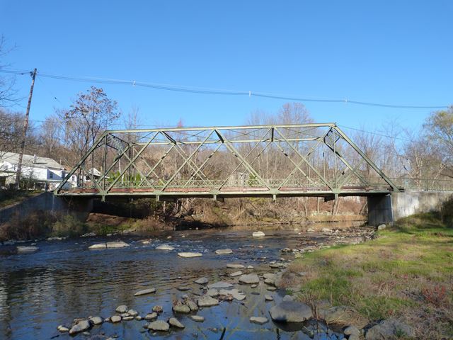
This bridge is an early example of a rivet-connected truss bridge. It is also noted for its uncommon double-Warren truss configuration. The bridge does not have major alterations to the trusses and the truss is in good condition, which only adds to its significance. The bridge retains ornamental railings as well. The design of these railings is similar to those used by the Berlin Iron Bridge Company except this bridge subsitutes decorative circular buttons for where Berlin used little flowers. Given this difference its not clear who built this bridge. The plaques on the bridge do not list the builder.
Information and Findings From New Jersey's Historic Bridge InventoryDiscussion of Bridge The double-intersection Warren thru-truss bridge is supported by gunite-coated abutments with wingwalls. The riveted truss is built of angles and batten plates for diagonals and the bottom chord, with channels and cover plates for the top chord and posts. In 1934, some diagonals were strengthened with welded channels. There are also bolted repairs. Despite the modifications, the span retains much of its original fabric, including handsome railings and is a rare example of an uncommon truss type. Discussion of Surrounding Area The bridge is located in an area of altered late-19th century structures used for residential and commercial purposes. The one-lane bridge carries a two-lane street of local traffic over a river. NJ 46 is located 500' north of the bridge. Bridge Considered Historic By Survey: No |
![]()
![]()
![]()
Coordinates (Latitude, Longitude):
Search For Additional Bridge Listings:
Bridgehunter.com: View listed bridges within 0.5 miles (0.8 kilometers) of this bridge.
Bridgehunter.com: View listed bridges within 10 miles (16 kilometers) of this bridge.
Additional Maps:
Google Streetview (If Available)
GeoHack (Additional Links and Coordinates)
Apple Maps (Via DuckDuckGo Search)
Apple Maps (Apple devices only)
Android: Open Location In Your Map or GPS App
Flickr Gallery (Find Nearby Photos)
Wikimedia Commons (Find Nearby Photos)
Directions Via Sygic For Android
Directions Via Sygic For iOS and Android Dolphin Browser
USGS National Map (United States Only)
Historical USGS Topo Maps (United States Only)
Historic Aerials (United States Only)
CalTopo Maps (United States Only)

© Copyright 2003-2024, HistoricBridges.org. All Rights Reserved. Disclaimer: HistoricBridges.org is a volunteer group of private citizens. HistoricBridges.org is NOT a government agency, does not represent or work with any governmental agencies, nor is it in any way associated with any government agency or any non-profit organization. While we strive for accuracy in our factual content, HistoricBridges.org offers no guarantee of accuracy. Information is provided "as is" without warranty of any kind, either expressed or implied. Information could include technical inaccuracies or errors of omission. Opinions and commentary are the opinions of the respective HistoricBridges.org member who made them and do not necessarily represent the views of anyone else, including any outside photographers whose images may appear on the page in which the commentary appears. HistoricBridges.org does not bear any responsibility for any consequences resulting from the use of this or any other HistoricBridges.org information. Owners and users of bridges have the responsibility of correctly following all applicable laws, rules, and regulations, regardless of any HistoricBridges.org information.
![]()