HistoricBridges.org Menu: HistoricBridges.org Menu:


We Recommend:
Bach Steel - Experts at historic truss bridge restoration.

HistoricBridges.org: Bridge Browser

Bear Mountain Bridge

Purple Heart Veterans Memorial Bridge

Bear Mountain Bridge

Primary Photographer(s): Nathan Holth

Bridge Documented: September 5, 2019

View Photos
and Videos
View Maps
and Links

Location
Rural: Rockland County, New York and Westchester County, New York: United States
Structure Type
Metal Deck Truss Stiffening Wire Cable Suspension, Fixed and Approach Spans: Metal Rivet-Connected ,
Rehabilitation Date
1977
Main Span Length
1,632.0 Feet (497.4 Meters)
Structure Length
2,257.0 Feet (687.9 Meters)
Roadway Width
38 Feet (11.58 Meters)
Spans
1 Main Span(s) and 5 Approach Span(s)
Inventory Number
5503400

Historic Significance Rating (HSR)
View Information About HSR Ratings

Bridge Documentation

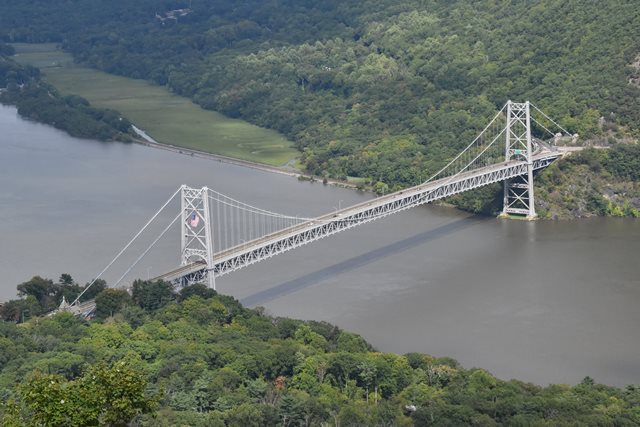
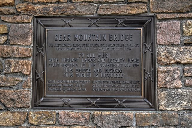
This is a spectacular suspension bridge located on an extremely scenic location in the shadow of impressive mountain terrain around the impressive Hudson River in this area. The bridge itself is noted for its design. It is a single-span suspension bridge, meaning it has only one suspended span instead of the traditional three spans. Instead, this bridge features unloaded back-stay cables. Another interesting detail is that the suspender cables attach to the deck truss stiffening at the bottom chord rather than the top chord. Thus, the main cable dips well below the deck at the center of the bridge, giving the bridge a somewhat unusual appearance for suspension bridges. Also noteworthy is that the bridge retains its original toll plaza including an administration building which is itself considered a historic building.

View Archived National Bridge Inventory Report - Has Additional Details and Evaluation

View National Register of Historic Places Nomination Form For This Bridge

View Historical Articles and Builder Bio About This Bridge

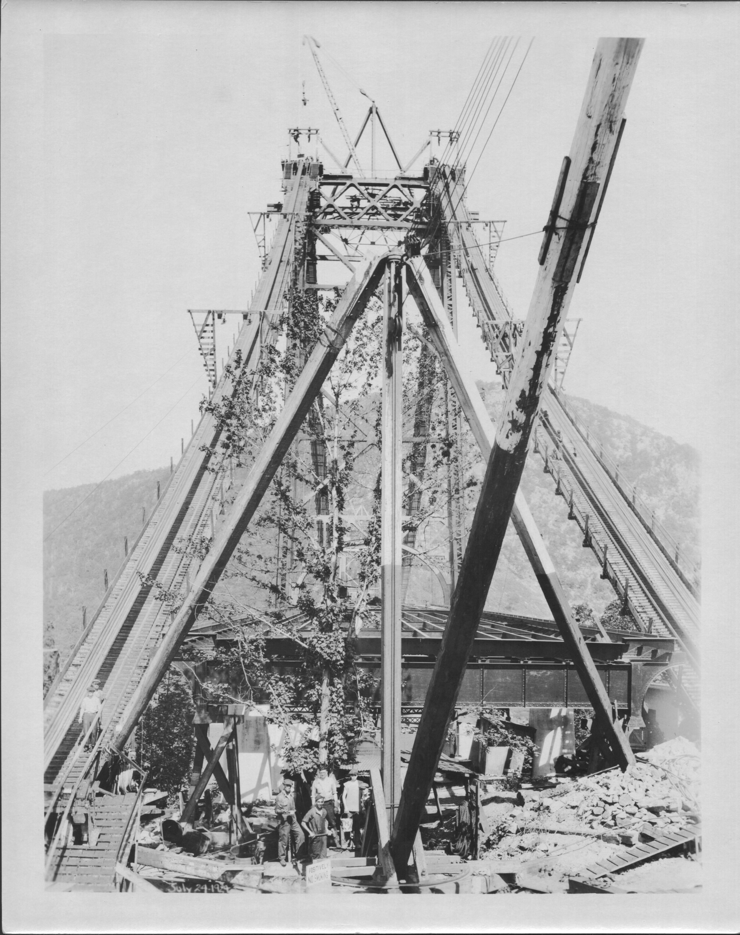
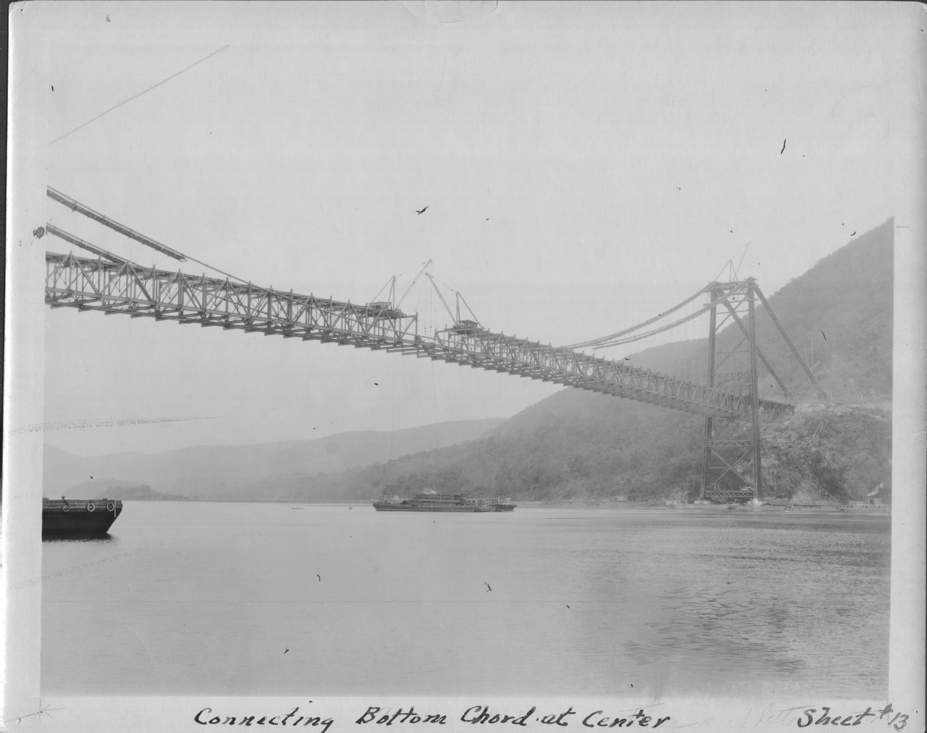
Below are some historical photos showing the construction of the bridge.

Divider

Photo Galleries and Videos: Bear Mountain Bridge


View Photo Gallery

Structure Overview

Original / Full Size Photos
A collection of overview photos that show the bridge as a whole and general areas of the bridge. This gallery offers photos in the highest available resolution and file size in a touch-friendly popup viewer.
Alternatively, Browse Without Using Viewer

Divider

View Photo Gallery

Structure Details

Original / Full Size Photos
A collection of detail photos that document the parts, construction, and condition of the bridge. This gallery offers photos in the highest available resolution and file size in a touch-friendly popup viewer.
Alternatively, Browse Without Using Viewer

Divider

View Photo Gallery

Structure Overview

Mobile Optimized Photos
A collection of overview photos that show the bridge as a whole and general areas of the bridge. This gallery features data-friendly, fast-loading photos in a touch-friendly popup viewer.
Alternatively, Browse Without Using Viewer

Divider

View Photo Gallery

Structure Details

Mobile Optimized Photos
A collection of detail photos that document the parts, construction, and condition of the bridge. This gallery features data-friendly, fast-loading photos in a touch-friendly popup viewer.
Alternatively, Browse Without Using Viewer

Divider

View Video

Historical Bridge Construction Video

Full Motion Video
Streaming video of the bridge. Also includes a higher quality downloadable video for greater clarity or offline viewing.

Divider

Maps and Links: Bear Mountain Bridge

Coordinates (Latitude, Longitude):

Search For Additional Bridge Listings:

Bridgehunter.com: View listed bridges within 0.5 miles (0.8 kilometers) of this bridge.

Bridgehunter.com: View listed bridges within 10 miles (16 kilometers) of this bridge.

HistoricBridges.org Bridge Browser: View listed bridges within 0.5 miles (0.8 kilometers) of this bridge.

HistoricBridges.org Bridge Browser: View listed bridges within 10 miles (16 kilometers) of this bridge.

2021 National Bridge Inventory: View listed bridges within 0.5 miles (0.8 kilometers) of this bridge.

Additional Maps:

Google Maps

Google Streetview (If Available)

Bing Maps

OpenStreetMap

GeoHack (Additional Links and Coordinates)

Apple Maps (Via DuckDuckGo Search)

Apple Maps (Apple devices only)

MapQuest

HERE We Go Maps

ACME Mapper

Waze Map

Android: Open Location In Your Map or GPS App

Flickr Gallery (Find Nearby Photos)

Wikimedia Commons (Find Nearby Photos)

Directions Via Sygic For Android

Directions Via Sygic For iOS and Android Dolphin Browser

USGS National Map (United States Only)

Historical USGS Topo Maps (United States Only)

Historic Aerials (United States Only)

CalTopo Maps (United States Only)


Divider
 
Home Top

Divider

About - Contact

© Copyright 2003-2024, HistoricBridges.org. All Rights Reserved. Disclaimer: HistoricBridges.org is a volunteer group of private citizens. HistoricBridges.org is NOT a government agency, does not represent or work with any governmental agencies, nor is it in any way associated with any government agency or any non-profit organization. While we strive for accuracy in our factual content, HistoricBridges.org offers no guarantee of accuracy. Information is provided "as is" without warranty of any kind, either expressed or implied. Information could include technical inaccuracies or errors of omission. Opinions and commentary are the opinions of the respective HistoricBridges.org member who made them and do not necessarily represent the views of anyone else, including any outside photographers whose images may appear on the page in which the commentary appears. HistoricBridges.org does not bear any responsibility for any consequences resulting from the use of this or any other HistoricBridges.org information. Owners and users of bridges have the responsibility of correctly following all applicable laws, rules, and regulations, regardless of any HistoricBridges.org information.

Admin Login

Divider