

View Information About HSR Ratings
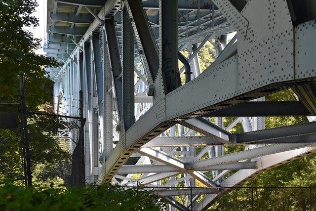
Although buried by thick forest and difficult to view, this is a large and impressive example of a cantilevered deck truss bridge.
Information and Findings From Ohio's Historic Bridge InventorySummary of Significance The 1948 continuous-cantilever design deck truss bridge is a later example of its type/design that is eligible from the prior inventory. No significant changes in the aspects of integrity were reported. The cantilever truss type/design developed in the U.S. during the 1880s and had emerged by the early 20th century as one of the dominant types for longer spans crossing deep or long rivers where it was difficult, if not impossible, to erect falsework. Truss designs used with cantilever trusses, e.g., Pratt or Warren, mirrored those of the period in which the bridge was built, as did the use of pinned or riveted connections. The great advantage of the cantilever is that it can be built outwards from the towers without falsework to block the channel. Suspended spans can be lifted into place between the cantilever arms. Span lengths of up to 500' are not uncommon, and in the longest examples can exceed 1,000'. The Ohio inventory includes 12 cantilever truss highway bridges dating from 1922 to 1960 (Phase 1A, 2008). Justification The bridge is one of 11 remaining examples of the design used for long, major crossings of both deck and thru trusses. They date from 1922 through the interstate era. This is not the most significant example. The bridge has moderate significance. Bridge Considered Historic By Survey: Yes |
![]()
![]()
![]()
Coordinates (Latitude, Longitude):
Search For Additional Bridge Listings:
Bridgehunter.com: View listed bridges within 0.5 miles (0.8 kilometers) of this bridge.
Bridgehunter.com: View listed bridges within 10 miles (16 kilometers) of this bridge.
Additional Maps:
Google Streetview (If Available)
GeoHack (Additional Links and Coordinates)
Apple Maps (Via DuckDuckGo Search)
Apple Maps (Apple devices only)
Android: Open Location In Your Map or GPS App
Flickr Gallery (Find Nearby Photos)
Wikimedia Commons (Find Nearby Photos)
Directions Via Sygic For Android
Directions Via Sygic For iOS and Android Dolphin Browser
USGS National Map (United States Only)
Historical USGS Topo Maps (United States Only)
Historic Aerials (United States Only)
CalTopo Maps (United States Only)

© Copyright 2003-2026, HistoricBridges.org. All Rights Reserved. Disclaimer: HistoricBridges.org is a volunteer group of private citizens. HistoricBridges.org is NOT a government agency, does not represent or work with any governmental agencies, nor is it in any way associated with any government agency or any non-profit organization. While we strive for accuracy in our factual content, HistoricBridges.org offers no guarantee of accuracy. Information is provided "as is" without warranty of any kind, either expressed or implied. Information could include technical inaccuracies or errors of omission. Opinions and commentary are the opinions of the respective HistoricBridges.org member who made them and do not necessarily represent the views of anyone else, including any outside photographers whose images may appear on the page in which the commentary appears. HistoricBridges.org does not bear any responsibility for any consequences resulting from the use of this or any other HistoricBridges.org information. Owners and users of bridges have the responsibility of correctly following all applicable laws, rules, and regulations, regardless of any HistoricBridges.org information.
![]()