

View Information About HSR Ratings
This three span stone arch bridge is among the oldest bridges in Ohio with an 1826 construction date. The arch ring of the western span which had severely deteriorated was rebuilt of concrete, and the overall bridge preserved in a noteworthy effort by a local group, the Blaine Bridge Community Preservation Project who was able to save this bridge in the face of demolition plans. As such, this bridge remains standing as the oldest of three generations of roadways following the route of the National Road. The second generation bridge, the high level Blaine Hill Viaduct is also historic and it looms in the background behind this arch bridge forming a unique and beautiful historic scene where two companion historic bridges stand side by side. I-70 is the third generation roadway following the National Road route.
John J. Crnkovich, Ed.D., P.E provided the following additional information which among other things shows that the 1828 construction date is incorrect: I spent two years recording the restoration of the Blaine "S" Bridge.(2003- 2005) My research found that the contract to build the bridge was let in 1825. The contract for the bridge was given to James Lloyd and Robert Wilson of Hagerstown, MD. They were also required to build one mile of road at each end of the bridge, so there could be no argument about the road and bridge meeting properly. In spite of the posted historical marker the bridge was finished in 1826. The bridge was rebuilt during 1915 when the original builder's marker was replaced by a concrete marker which stated the building date was 1826 and that it was rebuilt in 1915. Visited the site September 18, 2010, on the fifth anniversary of the Grand reopening. The bridge is in excellent condition.
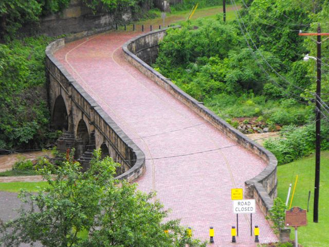
Information and Findings From Ohio's Historic Bridge InventorySetting/Context The bridge carries a pedestrian walkway over the stream in a setting of 20th-century residents at the foot of Blaine Hill. The open-spandrel arch bridge carrying US 40 is adjacent. Physical Description The 3 span, stone arch bridge has stone parapets, brick roadway surface, string course, coursed ashlar spandrel walls, and arch rings. The piers have rounded ends that extend upward into shaped, tapered pilasters. Built in 1826, it partially collapsed in 1998. Integrity Following the partial collapse in 1998, the bridge was rehabilitated to the Secretary of Interior's Standards (no adverse effect). Summary of Significance The Blaine "S" Bridge is one of the signature
bridges on the old National Road and was selected as Ohio's Bicentennial
Bridge. It has been rehabilitated without adversely effecting the
significance/integrity. The eligible recommendation of the prior
assessment remains appropriate. Justification The bridge ranks as oldest complete stone arch in the state, and it is a character-defining landmark on the National Road. It is the most historically and technologically example of its type in the state. Information From Previous 2006 Concrete Arch Report This bridge is Ohio' s official Bicentennial Bridge. It is a closed three-span, stone arch bridge built in 1828 and rebuilt in 1916. The bridge partially collapsed in 1998 and was saved from demolition in 1999. Since then the "S" Bridge has undergone major rehabilitation and been restored. The roadway over the bridge is paved in brick and has stone railings. A drainage system to collect runoff from the hill has been added to prevent water from running across the bridge. The bridge is on a 6.3% gradient and has excellent integrity. An Ohio historical marker has been placed at the east end of the bridge. Bridge Considered Historic By Survey: Yes |
![]()
![]()
![]()
Coordinates (Latitude, Longitude):
Search For Additional Bridge Listings:
Bridgehunter.com: View listed bridges within 0.5 miles (0.8 kilometers) of this bridge.
Bridgehunter.com: View listed bridges within 10 miles (16 kilometers) of this bridge.
Additional Maps:
Google Streetview (If Available)
GeoHack (Additional Links and Coordinates)
Apple Maps (Via DuckDuckGo Search)
Apple Maps (Apple devices only)
Android: Open Location In Your Map or GPS App
Flickr Gallery (Find Nearby Photos)
Wikimedia Commons (Find Nearby Photos)
Directions Via Sygic For Android
Directions Via Sygic For iOS and Android Dolphin Browser
USGS National Map (United States Only)
Historical USGS Topo Maps (United States Only)
Historic Aerials (United States Only)
CalTopo Maps (United States Only)

© Copyright 2003-2024, HistoricBridges.org. All Rights Reserved. Disclaimer: HistoricBridges.org is a volunteer group of private citizens. HistoricBridges.org is NOT a government agency, does not represent or work with any governmental agencies, nor is it in any way associated with any government agency or any non-profit organization. While we strive for accuracy in our factual content, HistoricBridges.org offers no guarantee of accuracy. Information is provided "as is" without warranty of any kind, either expressed or implied. Information could include technical inaccuracies or errors of omission. Opinions and commentary are the opinions of the respective HistoricBridges.org member who made them and do not necessarily represent the views of anyone else, including any outside photographers whose images may appear on the page in which the commentary appears. HistoricBridges.org does not bear any responsibility for any consequences resulting from the use of this or any other HistoricBridges.org information. Owners and users of bridges have the responsibility of correctly following all applicable laws, rules, and regulations, regardless of any HistoricBridges.org information.
![]()