

View Information About HSR Ratings
This impressive and massive high-level bridge sits next to the previous bridge at this crossing, the low-level 1828 Blaine Hill S Bridge. This site is a rare opportunity to photograph two very different historic bridges in one photo. The Blaine Hill Viaduct provides a beautiful background for the Blaine Hill S Bridge.
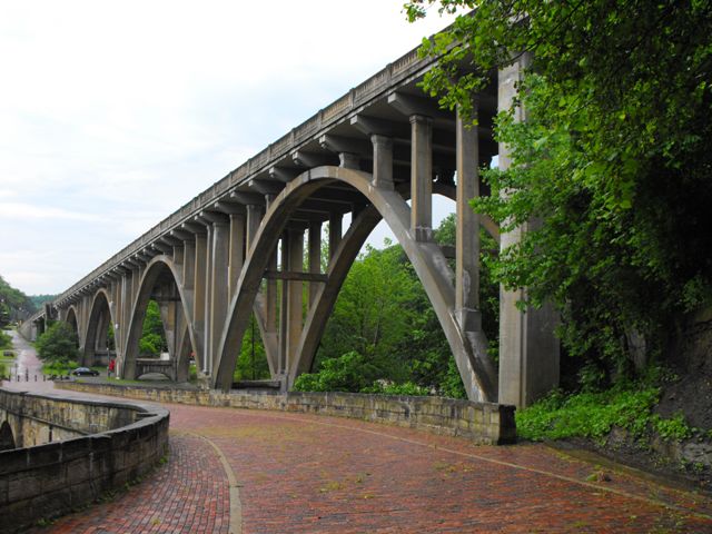
The Blaine Hill Viaduct is an impressive example of large-scale high level open spandrel arch construction, and is historically noteworthy on these grounds. There is a system of approach spans leading up to the main arch spans, and an interesting concrete staircase is also a part of this bridge. During rehabilitation the entire deck and flooring system was replaced. The new railings were designed to continue to look historic. The main loss of integrity in this rehabilitation was the replacement of concrete t-beam approach spans with concrete pre-stressed box beam spans.
Information and Findings From Ohio's Historic Bridge InventorySetting/Context The bridge a highway and sidewalk over a stream in a setting with a scattered mix of early- to late-20th century residential and commercial development at the base of Blaine Hill. The highway transitions from 2 lanes at the bridge's east end to 3 lanes on the bridge to provide an up-hill passing lane. The NR-listed Blaine "S" Bridge, part of the old National Road, is to the north side of the viaduct's main span over the stream. Physical Description The 11 span, 754'-long bridge built on a vertical profile has four open-spandrel-arch main spans and seven prestressed-concrete box beam spans (1982), which replaced the original T-beam approach spans. The bridge is supported on reinforced-concrete abutments and 2-column bents with arched cap beams. The 2-ribbed open-spandrel arch spans have spandrel columns with capitals that now carry a prestressed-concrete box beam deck. The original concrete balustrades have been replaced with concrete parapets/safety shape barrier textured on the exterior faces to appear like the original balustrades. The bridge's eastern approach roadway is carried on earth fill with concrete retaining walls. A reinforced-concrete staircase is located on the northeast corner of the easternmost arch span. Integrity Rehabilitation replaced arch spans from the deck up. Approach spans (originally T beams) replaced with box beams. Repaired spandrel columns and arch ribs (1982). Spalling and cracking of concrete noted in select locations including deck and spandrel columns (2009). Summary of Significance The 1932 open-spandrel arch bridge is one of Ohio's
signature bridges designed by D. H. Overman and the state bridge bureau
(Criterion C). Overman was the bridge bureau's "arch specialist" who was
noted for his aesthetic designs. The bridge was rehabilitated in 1982
without adverse effect. There are 25 open spandrel arch bridges dating
from 1907 to 1957 in the inventory (Phase 1A, 2008). Justification Because of the early emphasis on aesthetics at the local and state levels, Ohio has an impressive assemblage of long and shorter open spandrel arch bridges dating from 1907 through World War II. Twenty-three of the 25 predate World War II. This one is evaluated as having high significance because of its aesthetics and historic contexts including the crossing and the Ohio State Highway Department. Information From Previous 2006 Concrete Arch Report This bridge is an eleven span, open spandrel arch bridge that was built in 1933. It is known as the Blaine Hill Viaduct and overlooks the "S" Bridge. The viaduct is sloped downward toward the east and has one sidewalk on the north side. Stairs leading down below the bridge were located on the northeast end of the structure. It had closed concrete railings that have retained their integrity. The sidewalk was crumbling a little on the east end. Beneath the bridge the arches had no major problems, but had only minor chipping and rebar exposure. A column on the south side is cracked and spalling. Two plaques were mounted on the east end of the bridge and an Ohio historical marker for the viaduct is located beside the "S" Bridge. The bridge has been named the Arches of Memory and was dedicated to World War I veterans. It was also rededicated in 1982 by the American Legion and Belmont County Council. According to the Historic Bridge Inventory the structure underwent rehabilitation in the early 1980's. Bridge Considered Historic By Survey: Yes |
![]()
![]()
![]()
Coordinates (Latitude, Longitude):
Search For Additional Bridge Listings:
Bridgehunter.com: View listed bridges within 0.5 miles (0.8 kilometers) of this bridge.
Bridgehunter.com: View listed bridges within 10 miles (16 kilometers) of this bridge.
Additional Maps:
Google Streetview (If Available)
GeoHack (Additional Links and Coordinates)
Apple Maps (Via DuckDuckGo Search)
Apple Maps (Apple devices only)
Android: Open Location In Your Map or GPS App
Flickr Gallery (Find Nearby Photos)
Wikimedia Commons (Find Nearby Photos)
Directions Via Sygic For Android
Directions Via Sygic For iOS and Android Dolphin Browser
USGS National Map (United States Only)
Historical USGS Topo Maps (United States Only)
Historic Aerials (United States Only)
CalTopo Maps (United States Only)

© Copyright 2003-2025, HistoricBridges.org. All Rights Reserved. Disclaimer: HistoricBridges.org is a volunteer group of private citizens. HistoricBridges.org is NOT a government agency, does not represent or work with any governmental agencies, nor is it in any way associated with any government agency or any non-profit organization. While we strive for accuracy in our factual content, HistoricBridges.org offers no guarantee of accuracy. Information is provided "as is" without warranty of any kind, either expressed or implied. Information could include technical inaccuracies or errors of omission. Opinions and commentary are the opinions of the respective HistoricBridges.org member who made them and do not necessarily represent the views of anyone else, including any outside photographers whose images may appear on the page in which the commentary appears. HistoricBridges.org does not bear any responsibility for any consequences resulting from the use of this or any other HistoricBridges.org information. Owners and users of bridges have the responsibility of correctly following all applicable laws, rules, and regulations, regardless of any HistoricBridges.org information.
![]()