

View Information About HSR Ratings
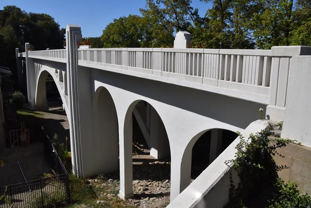
This beautifully detailed arch bridge has been fully restored.
Information and Findings From Ohio's Historic Bridge InventorySetting/Context The bridge carries a 2 lane street and sidewalks over a 2 lane street and valley in the Mt. Adams section of Cincinnati. The setting is a mix of early 20th century residential and commercial buildings with some modern buildings, including an apartment complex to the northeast of the bridge. Physical Description The 8 span, 388'-long bridge has two open spandrel arch main spans flanked by T beam approach spans with arched fascia beams. The 2-rib arch spans have spandrel columns with arched caps. The T beam spans have the interior beams transverse to the roadway and are framed into the arched fasciae beams. The bridge is finished in the Moderne style with stepped pilasters, pylons, and balustrades. The balustrades are a custom design with an alternating pattern of vertical scores, posts, and slats. Integrity Rehabilitated in 1981. Summary of Significance The Ida Street Viaduct is NR listed (1980). The 1931 open spandrel arch bridge is a handsome architectonic example in the Art Moderne-style that was so popular in Cincinnati in the late 1920s to 1930s. There are 25 open spandrel arch bridges dating from 1907 to 1957 in the inventory (Phase 1A, 2008). Justification Because of the early emphasis on aesthetics at the local and state levels, Ohio has an impressive assemblage of long and shorter open spandrel arch bridges dating from 1907 through World War II. Twenty-three of the 25 predate World War II. This example is representative of the genre and is of moderate level of significance. Bridge Considered Historic By Survey: Yes |
![]()
![]()
![]()
Coordinates (Latitude, Longitude):
Search For Additional Bridge Listings:
Bridgehunter.com: View listed bridges within 0.5 miles (0.8 kilometers) of this bridge.
Bridgehunter.com: View listed bridges within 10 miles (16 kilometers) of this bridge.
Additional Maps:
Google Streetview (If Available)
GeoHack (Additional Links and Coordinates)
Apple Maps (Via DuckDuckGo Search)
Apple Maps (Apple devices only)
Android: Open Location In Your Map or GPS App
Flickr Gallery (Find Nearby Photos)
Wikimedia Commons (Find Nearby Photos)
Directions Via Sygic For Android
Directions Via Sygic For iOS and Android Dolphin Browser
USGS National Map (United States Only)
Historical USGS Topo Maps (United States Only)
Historic Aerials (United States Only)
CalTopo Maps (United States Only)

© Copyright 2003-2024, HistoricBridges.org. All Rights Reserved. Disclaimer: HistoricBridges.org is a volunteer group of private citizens. HistoricBridges.org is NOT a government agency, does not represent or work with any governmental agencies, nor is it in any way associated with any government agency or any non-profit organization. While we strive for accuracy in our factual content, HistoricBridges.org offers no guarantee of accuracy. Information is provided "as is" without warranty of any kind, either expressed or implied. Information could include technical inaccuracies or errors of omission. Opinions and commentary are the opinions of the respective HistoricBridges.org member who made them and do not necessarily represent the views of anyone else, including any outside photographers whose images may appear on the page in which the commentary appears. HistoricBridges.org does not bear any responsibility for any consequences resulting from the use of this or any other HistoricBridges.org information. Owners and users of bridges have the responsibility of correctly following all applicable laws, rules, and regulations, regardless of any HistoricBridges.org information.
![]()