

View Information About HSR Ratings

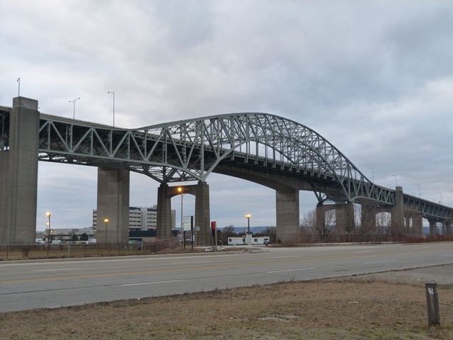
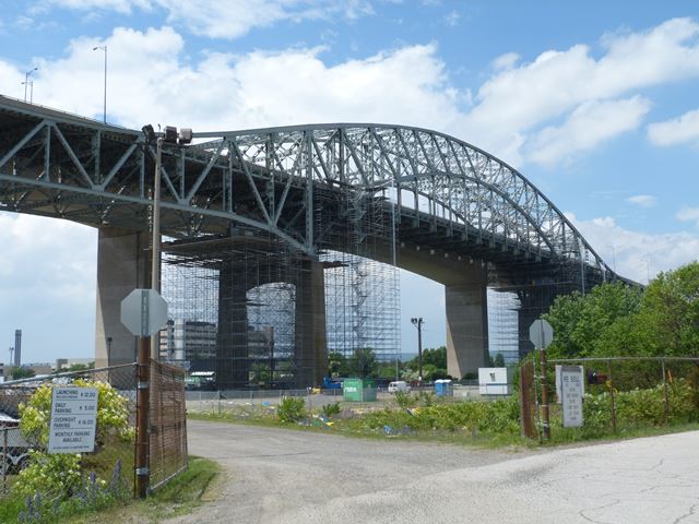
This bridge is a rare surviving example in Canada of a suspended deck truss bridge. The suspended deck variety of truss has the appearance of a though arch bridge, but functions as a arch-shaped continuous through truss. The arch shape of the truss takes the truss far above the height of the deck at the center of the span, and thus the deck must be connected to this section of the truss by hangers, which is the suspended deck portion of the bridge. A high level bridge that allows freighters to pass under the fixed bridge, this bridge has a very long approach system of deck truss and deck girder spans.
The bridge has a number of unusual details. The approach spans are unusual because they include a series of spans that are supported by two alternating types of supports: traditional concrete piers and unusual riveted steel piers. It is unclear why two different supports were used. The bridge also has unusual trussed floor beams. Floor beams are more commonly solid rolled or built-up i-beams. The trussed floor beams give the underside of the bridge a unique geometric complexity.
The bridge's channel span is 495 feet (150.9 meters) while the anchor spans on either side are 275 feet (83.8 meters).
John Turner Bell was a noted Hamilton architect who assisted in the design of this bridge. The famous Philip Louis Pratley was the consulting engineer for the bridge, although he died in 1958, the year this bridge was completed.
For such a major bridge, very little online information about the history of this bridge is available. HistoricBridges.org hopes to expand this article with additional information in the future.
In 1985, this bridge was turned into part of a one way couplet of bridges with the construction of a second high level bridge at this location. Now, the heritage bridge carries traffic toward Toronto while the new bridge carries traffic toward the Niagara Region. The construction of this second bridge is sometimes described as the "twinning" of the bridge. Such a statement is highly inaccurate and misleading however. The replacement bridge is one of the ugliest bridges ever encountered, with the appearance of little more than a slab of concrete. Visually, the second bridge only serves to obstruct the view of the heritage bridge. Absolutely no attempt appears to have been made to make the second bridge compliment the heritage bridge. The second bridge is useful however as a "teaching tool" to describe how most post 1970 bridges lack aesthetics or beauty of any kind, while unaltered pre-1970 bridges usually include at least some level of aesthetic quality.
At this time, HistoricBridges.org currently only has a few overview photos for this heritage bridge.
This bridge is tagged with the following special condition(s): Unorganized Photos
![]()
![]()
![]()
![]()
![]()
Coordinates (Latitude, Longitude):
Search For Additional Bridge Listings:
Additional Maps:
Google Streetview (If Available)
GeoHack (Additional Links and Coordinates)
Apple Maps (Via DuckDuckGo Search)
Apple Maps (Apple devices only)
Android: Open Location In Your Map or GPS App
Flickr Gallery (Find Nearby Photos)
Wikimedia Commons (Find Nearby Photos)
Directions Via Sygic For Android
Directions Via Sygic For iOS and Android Dolphin Browser

© Copyright 2003-2024, HistoricBridges.org. All Rights Reserved. Disclaimer: HistoricBridges.org is a volunteer group of private citizens. HistoricBridges.org is NOT a government agency, does not represent or work with any governmental agencies, nor is it in any way associated with any government agency or any non-profit organization. While we strive for accuracy in our factual content, HistoricBridges.org offers no guarantee of accuracy. Information is provided "as is" without warranty of any kind, either expressed or implied. Information could include technical inaccuracies or errors of omission. Opinions and commentary are the opinions of the respective HistoricBridges.org member who made them and do not necessarily represent the views of anyone else, including any outside photographers whose images may appear on the page in which the commentary appears. HistoricBridges.org does not bear any responsibility for any consequences resulting from the use of this or any other HistoricBridges.org information. Owners and users of bridges have the responsibility of correctly following all applicable laws, rules, and regulations, regardless of any HistoricBridges.org information.
![]()