We Recommend:
Bach Steel - Experts at historic truss bridge restoration.
Mitchell's Bridge

Primary Photographer(s): Nathan Holth
Bridge Documented: July 21, 2013
Not Available or Not Applicable
100.0 Feet (30.5 Meters)
140.0 Feet (42.7 Meters)
15 Feet (4.57 Meters)
1 Main Span(s) and 2 Approach Span(s)
Not Applicable

View Information About HSR Ratings
Bridge Documentation
This bridge no longer exists!
Bridge Status: Demolished and replaced.View a presentation about the planned demolition and replacement project.
View an original plan sheet for this bridge.
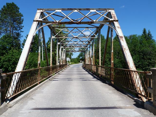
This bridge is a traditionally composed example of a rivet-connected Pratt truss bridge. It also includes a short concrete approach span at each end of the bridge. The bridge is largely unaltered and retains good historic integrity. The one exception is where i-beams have been welded onto the portal bracing. The portal bracing has been hit by over-height vehicles. HistoricBridges.org would recommend that the bridge have headache bars placed at each end. These would prevent trucks from hitting the bridge since they would hit the headache bar first. The bridge also does suffer from a failing paint system, which is allowing rust and section loss to develop, particularly in traditional trouble spots such as bottom chord connections. However, it would be feasible to rehabilitate the bridge for continued light vehicular use. There has been some interest from local residents in preserving the bridge. However, Kawartha Lakes instead plans to demolish and replace this bridge with an ugly modern bridge that will be devoid of heritage value. This is a disappointing decision. Structural deterioration of the bridge was one of the problems identified with the bridge. However the biggest issue was that there is a desire to provide for increased traffic capacity and/or increased safety for greater traffic volumes.
Based on HistoricBridges.org's review of the bridge, rehabilitation would have been feasible for this bridge, in terms of structural condition. Bridges in similar or worse condition have been rehabilitated elsewhere. The East Delhi Road Bridge in Michigan is a great example, that bridge actually being far older and more lightweight than this bridge.
Providing for higher volumes of traffic without demolishing the heritage bridge could have been provided for in a number of ways. The bridge could be bypassed by a modern two-lane bridge and the heritage bridge left standing for pedestrian use. The bridge could be relocated and preserved for pedestrian use in a new location. A new one-lane bridge could be built next to the bridge and the heritage bridge rehabilitated, to form a one-way couplet of bridges that together create a two lane crossing. Or, the bridge could be rehabilitated as is, and traffic control like a stoplight at each end of the bridge could be installed to safely and efficiently carry larger volumes of traffic over the one lane bridge. With all these options, which would have a wide variety of costs as well, certainly one of these alternatives could have been chosen to prevent this bridge from being the latest heritage bridge in Ontario to be reduced to scrap metal.
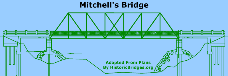
At a Public Information Meeting, a prepared drawing of the existing heritage bridge was included by the consulting engineer. In this drawing, the diagonal members of the bridge were not represented correctly. If you look at the above drawing corrected by HistoricBridges.org, you can see how it should look. The consultant had drawn the bridge with the right two diagonal flipped horizontally. Communication to HistoricBridges.org from the consultant said that the reason for this inaccuracy was because the drawings were schematic in nature and that conveying the actual details of the truss design were more complex than was needed to explain the bridge and the available alternatives to the public and stakeholders.
Thanks to Andrew Superville for supplying a scan of the original plan sheet (the only surviving one found) of this bridge.
![]()
Photo Galleries and Videos: Mitchell's Bridge
Bridge Photo-Documentation
Original / Full Size PhotosA collection of overview and detail photos. This gallery offers photos in the highest available resolution and file size in a touch-friendly popup viewer.
Alternatively, Browse Without Using Viewer
![]()
Bridge Photo-Documentation
Mobile Optimized PhotosA collection of overview and detail photos. This gallery features data-friendly, fast-loading photos in a touch-friendly popup viewer.
Alternatively, Browse Without Using Viewer
![]()
Maps and Links: Mitchell's Bridge
This historic bridge has been demolished. This map is shown for reference purposes only.
Coordinates (Latitude, Longitude):
Search For Additional Bridge Listings:
Additional Maps:
Google Streetview (If Available)
GeoHack (Additional Links and Coordinates)
Apple Maps (Via DuckDuckGo Search)
Apple Maps (Apple devices only)
Android: Open Location In Your Map or GPS App
Flickr Gallery (Find Nearby Photos)
Wikimedia Commons (Find Nearby Photos)
Directions Via Sygic For Android
Directions Via Sygic For iOS and Android Dolphin Browser


