HistoricBridges.org Menu: HistoricBridges.org Menu:


We Recommend:
Bach Steel - Experts at historic truss bridge restoration.

HistoricBridges.org: Bridge Browser

Sauble Falls Bridge

Sauble Falls Bridge

Primary Photographer(s): Nathan Holth

Bridge Documented: January 1, 2007

View Photos
and Videos
View Maps
and Links

Facility Carried / Feature Intersected
Sauble Falls Parkway (Old Alignment) Over Sauble River
Location
Sauble Falls: Bruce County, Ontario: Canada
Structure Type
Concrete Through Girder, Fixed
Construction Date and Builder / Engineer
1930 By Builder/Contractor: Theodore Seaman
Rehabilitation Date
Not Available or Not Applicable
Main Span Length
44.3 Feet (13.5 Meters)
Structure Length
112.2 Feet (34.2 Meters)
Roadway Width
Not Available
Spans
3 Main Span(s)
Inventory Number
Not Applicable

Historic Significance Rating (HSR)
View Information About HSR Ratings

Bridge Documentation

View Minutes Detailing The Heritage Designation For This Bridge

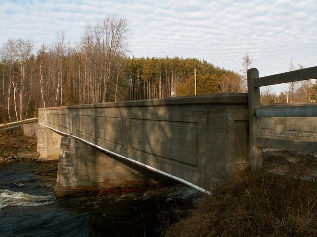
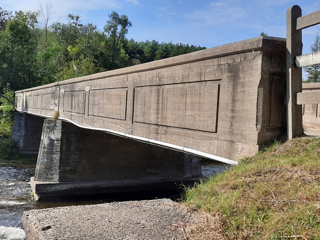
This bridge appears to be the largest and most significant remaining bridge in the Bruce Peninsula. It is a rare example of a multi-span concrete through girder in Ontario. Architectural expression is limited to the rectangular outlines on the girders.

There are two main spans to this bridge, and a third shorter approach span at the northern end of the bridge. The tops of the girders have concrete that appears to be slightly newer than the rest of the girders, most likely evidence of a repair project from many decades ago. The structure appears to be in excellent condition with no evidence of spalling.

A plaque on a modern bridge that parallels this bridge has a 1966 plaque on it, suggesting that this bridge ceased serving vehicular traffic in that year.

Located in a park setting, this bridge is in the perfect place for preservation. Fortunately, the local community seems to care about the future of this bridge, as the structure was nominated through the Ontario Heritage Act.

Ontario Heritage Act Designation Nomination Findings

STATEMENT OF CULTURAL HERITAGE VALUE

The Sauble Falls Bridge is of cultural heritage value as an early example of access across a waterway. The current bridge replaced the original wooden structure and foot bridge which faced washouts during severe weather events.

As recorded in the Council Minutes from October 10, 1922, the Corporation of the Township of Amabel was approached by Mr. Seaman with his concerns about the changes to the road at Sauble Falls. Subsequent to this, Council commissioned G.E. Stephenson, the County Engineer, to prepare plans and specifications for the construction of the bridge. The tender submitted by Theodore Seaman was accepted by Council on May 29, 1929. Municipal Council saw the value of the bridge construction as it served as an access to the community north of the river which was comprised of a school house, power electric plant, post office, store and private residences.

The bridge and road allowance are of value to the community as the only built heritage component in the immediate Sauble Falls area which remains true to its original use; a bridge and means to cross the Sauble River.

DESCRIPTION OF HERITAGE ATTRIBUTES

Key attributes of the bridge and road allowance site that reflect their value as an important link to the history of the Town of South Bruce Peninsula include:

-Original reinforced concrete and steel bridge construction
-Demonstrates traveled route of original settlers
-The bridge is the last untouched structure at Sauble Falls which represents 1920/1930 architecture
-The site is a reminder to future generations of settlement patterns and the importance of waterway access to the early commercial and residential development at Sauble Falls

Divider

Photo Galleries and Videos: Sauble Falls Bridge


View Photo Gallery

2006 Bridge Photo-Documentation

A collection of overview and detail photos. This photo gallery contains a combination of Original Size photos and Mobile Optimized photos in a touch-friendly popup viewer.
Alternatively, Browse Without Using Viewer

Divider

View Photo Gallery

2020 Bridge Photo-Documentation

Original / Full Size Photos
A collection of overview and detail photos. This gallery offers photos in the highest available resolution and file size in a touch-friendly popup viewer.
Alternatively, Browse Without Using Viewer

Divider

View Photo Gallery

2020 Bridge Photo-Documentation

Mobile Optimized Photos
A collection of overview and detail photos. This gallery features data-friendly, fast-loading photos in a touch-friendly popup viewer.
Alternatively, Browse Without Using Viewer

Divider

Maps and Links: Sauble Falls Bridge

Coordinates (Latitude, Longitude):

Search For Additional Bridge Listings:

HistoricBridges.org Bridge Browser: View listed bridges within 0.5 miles (0.8 kilometers) of this bridge.

HistoricBridges.org Bridge Browser: View listed bridges within 10 miles (16 kilometers) of this bridge.

Additional Maps:

Google Maps

Google Streetview (If Available)

Bing Maps

OpenStreetMap

GeoHack (Additional Links and Coordinates)

Apple Maps (Via DuckDuckGo Search)

Apple Maps (Apple devices only)

MapQuest

HERE We Go Maps

ACME Mapper

Waze Map

Android: Open Location In Your Map or GPS App

Flickr Gallery (Find Nearby Photos)

Wikimedia Commons (Find Nearby Photos)

Directions Via Sygic For Android

Directions Via Sygic For iOS and Android Dolphin Browser


Divider
 
Home Top

Divider

About - Contact

© Copyright 2003-2024, HistoricBridges.org. All Rights Reserved. Disclaimer: HistoricBridges.org is a volunteer group of private citizens. HistoricBridges.org is NOT a government agency, does not represent or work with any governmental agencies, nor is it in any way associated with any government agency or any non-profit organization. While we strive for accuracy in our factual content, HistoricBridges.org offers no guarantee of accuracy. Information is provided "as is" without warranty of any kind, either expressed or implied. Information could include technical inaccuracies or errors of omission. Opinions and commentary are the opinions of the respective HistoricBridges.org member who made them and do not necessarily represent the views of anyone else, including any outside photographers whose images may appear on the page in which the commentary appears. HistoricBridges.org does not bear any responsibility for any consequences resulting from the use of this or any other HistoricBridges.org information. Owners and users of bridges have the responsibility of correctly following all applicable laws, rules, and regulations, regardless of any HistoricBridges.org information.

Admin Login

Divider