We Recommend:
Bach Steel - Experts at historic truss bridge restoration.
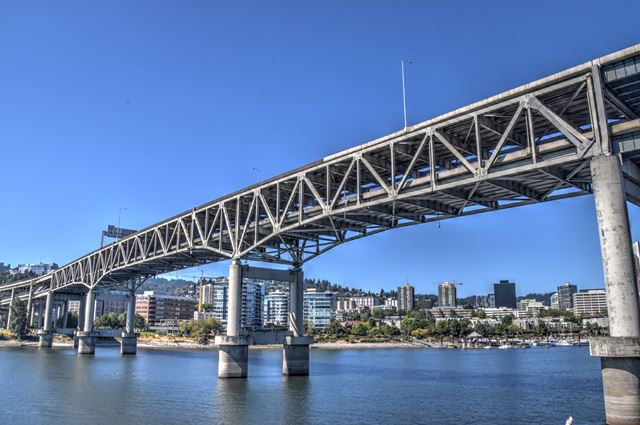
Marquam Bridge

Primary Photographer(s): Nathan Holth
Bridge Documented: September 3, 2018
Portland: Multnomah County, Oregon: United States
Metal Cantilever 14 Panel Multiple-Type-Connected Warren Deck Truss, Fixed and Approach Spans: Metal Stringer (Multi-Beam), Fixed
1966 By Builder/Contractor: American Bridge Company of New York, New York and Engineer/Design: Ivan D. Merchant
1996
440.0 Feet (134.1 Meters)
5,280.0 Feet (1609.3 Meters)
114 Feet (34.75 Meters)
3 Main Span(s)
8328

View Information About HSR Ratings
Bridge Documentation
View Archived National Bridge Inventory Report - Has Additional Details and Evaluation
View Historic American Engineering Record (HAER) Documentation For This Bridge
HAER Data Pages, PDF
View Historic Bridge Inventory Sheet For This Bridge
HAER Documentation, Willamette River Bridges - Data Pages - Drawings -Timeline
This utilitarian mid-20th century truss bridge is noted for its unusual double-deck cantilever truss design. The bridge has a local reputation as the "ugly" bridge, since it lacks the aesthetics of earlier bridges, and even bridges built after this bridge such as the Fremont Bridge were designed with a greater attention to aesthetics (as unusual as that normally is in modern bridge design). Despite this reputation for being "ugly," the bridge is nicer looking than a typical slab of concrete, and it also has some interesting design details. Double-deck bridges are uncommon, and this example with its cantilever truss design is particularly unusual. The design includes a suspended span between the cantilever arms of the center truss span. It appears this bridge was constructed using rivets to attach part of the truss gusset plates in a shop setting, while the remaining fasteners on the connections which would have been installed in the field were made using bolts. The bridge also includes an enormous and complex series of approach ramps, the design and details being beyond the scope of HistoricBridges.org's documentation. The total length given here is a rough measurement from each end of the approach ramps when traveling over the bridge via I-5, which comes out to about a mile in length. The National Bridge Inventory counts the "bridge" as just the three truss spans, which total 1,044 feet, however these truss spans do not even complete the crossing over the river, with adjacent ramp girder spans crossing the remainder of the river. An exact definition of where this bridge starts and ends is not easy to establish. The bridge has alterations that appear to be earthquake-related retrofits, particularly in the area of the hangers for the suspended span.
The general contractor for this bridge, Kiewit Corporation of Omaha, Nebraska, remains in business today as one of the largest contractors in the country. American Bridge Company was the steel fabricator for the bridge.
This bridge is tagged with the following special condition(s): Double-Deck
![]()
Photo Galleries and Videos: Marquam Bridge
Bridge Photo-Documentation
Original / Full Size PhotosA collection of overview and detail photos. This gallery offers photos in the highest available resolution and file size in a touch-friendly popup viewer.
Alternatively, Browse Without Using Viewer
![]()
Bridge Photo-Documentation
Mobile Optimized PhotosA collection of overview and detail photos. This gallery features data-friendly, fast-loading photos in a touch-friendly popup viewer.
Alternatively, Browse Without Using Viewer
![]()
Maps and Links: Marquam Bridge
Coordinates (Latitude, Longitude):
Search For Additional Bridge Listings:
Bridgehunter.com: View listed bridges within 0.5 miles (0.8 kilometers) of this bridge.
Bridgehunter.com: View listed bridges within 10 miles (16 kilometers) of this bridge.
Additional Maps:
Google Streetview (If Available)
GeoHack (Additional Links and Coordinates)
Apple Maps (Via DuckDuckGo Search)
Apple Maps (Apple devices only)
Android: Open Location In Your Map or GPS App
Flickr Gallery (Find Nearby Photos)
Wikimedia Commons (Find Nearby Photos)
Directions Via Sygic For Android
Directions Via Sygic For iOS and Android Dolphin Browser
USGS National Map (United States Only)
Historical USGS Topo Maps (United States Only)
Historic Aerials (United States Only)
CalTopo Maps (United States Only)


