

View Information About HSR Ratings

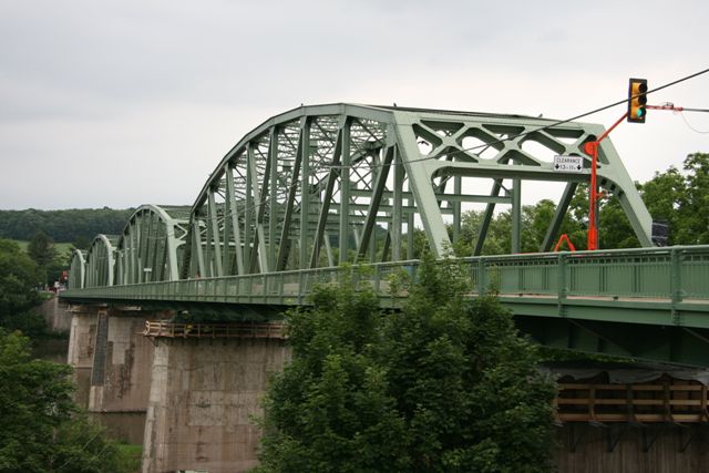
The Port Royal Bridge proper is a four span through truss bridge with a single through plate girder approach span. However, in reality the bridge is far more than just that, with an additional two bridges together creating a single viaduct, making this structure a unique and fascinating bridge. Leading up to the main truss bridge, there is a concrete arch bridge that crosses the Pennsylvania Railroad trackage. This arch bridge is actually much older than the truss bridge and dates to 1910, and this historically significant bridge has been given its own page on HistoricBridges.org. Before the truss bridge was built, this arch bridge carried Market Street up and over the railroad tracks, then back down to apparantly connect directly with 1st Street. There was a previous bridge over the river in Port Royal, a wooden covered bridge which the 1937 bridge replaced, but it was located 250 feet north of this location. When the truss bridge was built, the northeastern end of the arch bridge was reconfigured and raised up, then attached to the truss bridge via a steel stringer span. There is also a two-span steel stringer bridge, referred to as the 1st Street Ramp that connects this viaduct to 1st Street which passes under the plate girder approach span. The ramp intersects with the main bridge at a nearly 90 degree angle between the stringer span that connects to the arch bridge and the plate girder approach span of the truss bridge. There are very few surviving bridges that contain such an intersection right in the middle of the bridge.

The truss bridge itself is a traditionally composed example of one of the most popular designs of state standard plan truss bridge in Pennsylvania that were built in the first half of the 20th Century, mostly in the 1930s. Bridges such as this were once common on Pennsylvania's landscape. However due to demolition and replacement they are becoming quite uncommon. In particular, examples that have more than two truss bridges in them are quickly becoming exceedingly rare. As such, the surviving longer examples such as the four truss span Port Royal Bridge should be considered noteworthy.
Fortunately, PennDOT chose to rehabilitate this bridge in 2010 with a repair and repainting project. It is excellent to see PennDOT has chosen to give this bridge new life rather than adding it to the rather long list of demolished truss bridges in Pennsylvania. The decision to rehabilitate this bridge does not only represent preservation, it also represents sound fiscal responsibility, since the project most certainly costs far less than a demolition and replacement project would. However, this project falls a bit short of an excellent preservation project, because the repair and/or repainting of the 1st Street Ramp and the 1910 arch bridge are not a part of the project. Instead, there are plans to demolish and replace the 1st Street Ramp. The future of the arch bridge is not confirmed, but it future is probably not bright.

Information and Findings From Pennsylvania's Historic Bridge InventoryDiscussion of Bridge The 8-span, 1087'-long bridge, built in 1937, is composed of four Parker thru truss spans over the river, measuring approximately 222'-long each, a steel thru girder span over the street, and two steel stringer and a reinforced concrete slab approach spans. The deck was replaced in 1975 and the slab span replaced a steel stringer span in 1982. The rivet-connected trusses are composed of standard built-up chords and rolled steel section verticals and diagonals. The bridge is a late and undistinguished example of a truss design developed in the 1870s and used by the state highway department as a standard beginning in the 1920s. It has no noteworthy details. More than 75 examples from the 1920s to 1940s have been identified. The bridge is not distinguished by its setting, nor is it significant in association with the development of Port Royal. The town grew in association with the railroad as a local commercial and transportation center for the countryside from the late 1840s to about 1910. The bridge was built as a standard state highway department replacement project for a covered bridge. Discussion of Surrounding Area The bridge carries a 2-lane highway and sidewalk over the Juniata River and a 2-lane street in Port Royal. The bridge is part of a viaduct that includes a reinforced concrete arch bridge (34 0075 0670 0067), built in 1910, that spans over the Pennsylvania RR Main Line. The arch bridge is evaluated significant in association with the historic rail line (DOE 9/14/93). A 2-span, 80'-long, steel stringer bridge (34 3031 0010 0000) serves as a ramp between the viaduct and First Street at the bridge's northwest end. At the viaduct's western quadrants on First Street in Port Royal are a row of residences dating from the 19th century. While the residences at the northwest quadrant of the bridge have architectural integrity, those at the southwest quadrant are altered with replacement siding and windows, additions, and conversions to apartments. The immediate setting does not have the over all continuity or integrity of a historic district. Bridge Considered Historic By Survey: No Discussion of 1st Street (River Road) Ramp The two-span, 80'-long, steel stringer bridge is composed of rolled steel section stringers with steel diaphragms and a concrete deck. It is supported on concrete-filled, fluted steel pile bents with concrete caps, and is finished with welded metal railings with concrete posts. The bridge is a historically and technologically undistinguished example of the state's most common 20th-century highway bridge type, with over 4,300 pre-1957 examples, many dating to before 1910. It has no noteworthy details. The bridge is not distinguished by its setting, nor is it significant in association with the development of Port Royal or the construction of the SR 75 viaduct. The town grew in association with the railroad as a local commercial and transportation center from the late 1840s to about 1910. A covered bridge spanned the Juniata River at Port Royal at least as early as 1875. The 1937 SR 75 viaduct and ramp is a later improvement, initiated by the state highway department as one of many such projects throughout the state to replace older bridges incorporated into the state highway system during the 1910s and 1920s. The viaduct and ramp are not significant in association with the historic development of Port Royal. Discussion of Surrounding Area of 1st Street (River Road) Ramp The bridge carries a 2-lane ramp from First Street to the SR 75 steel truss viaduct over the Juniata River in Port Royal. To the bridge's east are a row of residences dating from the mid-19th to late-19th century. While the residence immediately northeast of the ramp has over all architectural integrity, those to the southeast of the viaduct are very altered with replacement siding and windows, additions, and conversions to apartments. The immediate setting does not have the continuity or integrity of a historic district. The reinforced concrete arch bridge (34 0075 0670 0067) adjoining the west end of the ramp spans over the Pennsylvania RR Main Line. The line has been evaluated historically significant by PHMC (DOE 8/11/94). The arch bridge, built 27 years prior to the steel truss viaduct as a grade-crossing elimination project, is recommended historically significant in association with the line. Bridge Considered Historic By Survey: No |
![]()
![]()
![]()

![]()
![]()
Coordinates (Latitude, Longitude):
Search For Additional Bridge Listings:
Bridgehunter.com: View listed bridges within 0.5 miles (0.8 kilometers) of this bridge.
Bridgehunter.com: View listed bridges within 10 miles (16 kilometers) of this bridge.
Additional Maps:
Google Streetview (If Available)
GeoHack (Additional Links and Coordinates)
Apple Maps (Via DuckDuckGo Search)
Apple Maps (Apple devices only)
Android: Open Location In Your Map or GPS App
Flickr Gallery (Find Nearby Photos)
Wikimedia Commons (Find Nearby Photos)
Directions Via Sygic For Android
Directions Via Sygic For iOS and Android Dolphin Browser
USGS National Map (United States Only)
Historical USGS Topo Maps (United States Only)
Historic Aerials (United States Only)
CalTopo Maps (United States Only)

© Copyright 2003-2026, HistoricBridges.org. All Rights Reserved. Disclaimer: HistoricBridges.org is a volunteer group of private citizens. HistoricBridges.org is NOT a government agency, does not represent or work with any governmental agencies, nor is it in any way associated with any government agency or any non-profit organization. While we strive for accuracy in our factual content, HistoricBridges.org offers no guarantee of accuracy. Information is provided "as is" without warranty of any kind, either expressed or implied. Information could include technical inaccuracies or errors of omission. Opinions and commentary are the opinions of the respective HistoricBridges.org member who made them and do not necessarily represent the views of anyone else, including any outside photographers whose images may appear on the page in which the commentary appears. HistoricBridges.org does not bear any responsibility for any consequences resulting from the use of this or any other HistoricBridges.org information. Owners and users of bridges have the responsibility of correctly following all applicable laws, rules, and regulations, regardless of any HistoricBridges.org information.
![]()