

View Information About HSR Ratings

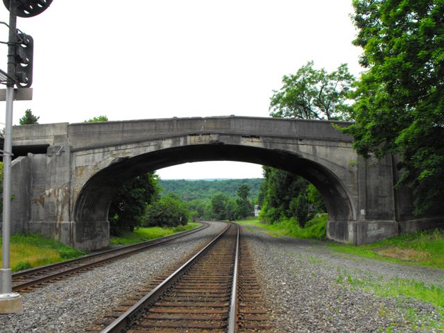
The Port Royal Bridge proper is a four span through truss bridge with a single through plate girder approach span. However, in reality the bridge is far more than just that, with an additional two bridges together creating a single viaduct, making this structure a unique and fascinating bridge. Leading up to the main truss bridge, there is this concrete arch bridge that crosses the Pennsylvania Railroad trackage. This arch bridge is actually much older than the truss bridge and dates to 1910 and is on its own considered eligible for listing in the National Register of Historic Places for its association with the Pennsylvania Railroad. This page is dedicated to the arch bridge. The remainder of the Port Royal Viaduct has its own page on HistoricBridges.org. Before the truss bridge was built, this arch bridge carried Market Street up and over the railroad tracks, then back down to apparently connect directly with 1st Street. There was a previous bridge over the river in Port Royal, a wooden covered bridge which the 1937 bridge replaced, but it was located 250 feet north of this location. When the truss bridge was built, the northeastern end of the arch bridge was reconfigured and raised up, then attached to the truss bridge via a steel stringer span. There is also a two-span steel stringer bridge, referred to as the 1st Street Ramp that connects this viaduct to 1st Street which passes under the plate girder approach span. The ramp intersects with the main bridge at a nearly 90 degree angle between the stringer span that connects to the arch bridge and the plate girder approach span of the truss bridge. There are very few surviving bridges that contain such an intersection right in the middle of the bridge.
The arch bridge itself is a somewhat unusual example of a concrete arch bridge railroad overpass. Structurally however it is technologically significant as an extremely old example of a concrete arch bridge, with a 1910 construction date. Historically, the bridge is significant also for its association with the historically significant Pennsylvania Railroad line. Aesthetically, the bridge is attractively constructed, with architectural details cast into the concrete of both the arch and the abutment.
Although PennDOT made the excellent choice to rehabilitate the truss spans of the Port Royal Viaduct, in 2010 with a repair and repainting project, the repair and/or repainting of the 1st Street Ramp and the 1910 arch bridge are not a part of the project. Instead, there are plans to demolish and replace the 1st Street Ramp. The future of the arch bridge is not confirmed, but it future is probably not bright, despite the fact that the arch bridge is the most significant portion of the viaduct in terms of historical significance.
Information and Findings From Pennsylvania's Historic Bridge InventoryDiscussion of Bridge The one-span, 87'-long, reinforced concrete arch bridge is supported on concrete abutments with paneled pilasters at the corners. The bridge has concrete parapets and paneled spandrel walls to accent the arch. The date "1910" is inscribed at the crown. As part of the extension of the viaduct in 1937, the parapets and posts over the east wingwalls were removed. The arch bridge is historically significant in association with the PRR Main Line. It dates from a period when the PRR concentrated on eliminating dangerous at-grade crossings in cities and towns. The bridge is complete except for the loss of two sections of parapet over the east wingwalls. Although not individually distinguished, it contributes to the historic railroad line. Discussion of Surrounding Area The bridge carries a 2 lane road and a sidewalk over 2 active railroad tracks of Conrail's/Amtrak's Pittsburgh-Philadelphia main line. The railroad is the historically significant PRR Main Line that has been determined eligible by PHMC (9/14/93). The bridge is located in Port Royal, in a mixed-use commercial and residential setting of 19th- and early 20th century buildings. The buildings in the immediate setting have significant alterations including replacement windows, enclosed porches, and the addition of modern storefronts and siding. The railroad station at the bridge's northwest quadrant has been lost. The bridge is the westernmost span in a viaduct that carries SR 75 over the railroad, First Street and the Juniata River. The slab, steel stringer, thru girder and Parker thru truss spans (BMS#'s 34 0075 0680 0000 & 34 3031 00010 0000) to the east of the arch were placed in 1937 by the state highway department as part of a project to replace a covered bridge, once located on an alignment approximately 250' north of the present crossing. The 1937 sections of the viaduct are not historically or technologically significant. Bridge Considered Historic By Survey: Yes |
![]()
![]()
![]()

![]()
Coordinates (Latitude, Longitude):
Search For Additional Bridge Listings:
Bridgehunter.com: View listed bridges within 0.5 miles (0.8 kilometers) of this bridge.
Bridgehunter.com: View listed bridges within 10 miles (16 kilometers) of this bridge.
Additional Maps:
Google Streetview (If Available)
GeoHack (Additional Links and Coordinates)
Apple Maps (Via DuckDuckGo Search)
Apple Maps (Apple devices only)
Android: Open Location In Your Map or GPS App
Flickr Gallery (Find Nearby Photos)
Wikimedia Commons (Find Nearby Photos)
Directions Via Sygic For Android
Directions Via Sygic For iOS and Android Dolphin Browser
USGS National Map (United States Only)
Historical USGS Topo Maps (United States Only)
Historic Aerials (United States Only)
CalTopo Maps (United States Only)

© Copyright 2003-2024, HistoricBridges.org. All Rights Reserved. Disclaimer: HistoricBridges.org is a volunteer group of private citizens. HistoricBridges.org is NOT a government agency, does not represent or work with any governmental agencies, nor is it in any way associated with any government agency or any non-profit organization. While we strive for accuracy in our factual content, HistoricBridges.org offers no guarantee of accuracy. Information is provided "as is" without warranty of any kind, either expressed or implied. Information could include technical inaccuracies or errors of omission. Opinions and commentary are the opinions of the respective HistoricBridges.org member who made them and do not necessarily represent the views of anyone else, including any outside photographers whose images may appear on the page in which the commentary appears. HistoricBridges.org does not bear any responsibility for any consequences resulting from the use of this or any other HistoricBridges.org information. Owners and users of bridges have the responsibility of correctly following all applicable laws, rules, and regulations, regardless of any HistoricBridges.org information.
![]()