

View Information About HSR Ratings
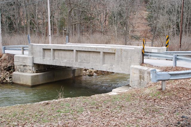
This small concrete through girder is one of the oldest of its kind and has good historic integrity.
Information and Findings From Pennsylvania's Historic Bridge InventoryDiscussion of Bridge The single span, 34'-long, reinforced concrete thru girder bridge built in 1909 is supported on concrete abutments with wingwalls. The paneled girders also serve as the parapets. The bridge has transverse floorbeams, a longitudinal beam at the center line, and a concrete deck. Like other reinforced concrete bridge types, such as T beams and slabs, thru girder bridges appeared during the first decade of the 20th century. They were one of the least successful of the standardized types mainly because they proved less economical than T beam bridges for the same span lengths and were limited to relatively narrow roadway widths. In Pennsylvania, the type was never widely popular, and it was used mainly in a small number of counties. This example is one of the oldest and most complete examples in southeastern Pennsylvania (PADOT Districts 6 & 8) , and one of the two oldest identified examples from 1909-1910 in York County. It is historically and technologically significant as an early application of the technology. Discussion of Surrounding Area The bridge carries a 1 lane road over a stream in a rural setting with scattered 19th to late 20th century residences, approximately 1/4 mile southwest of the rural village of Seitzland. Fields or woods are to each of the quadrants. The road is closed to traffic with an earth barrier. The setting does not have the cohesiveness or integrity of a historic district. Bridge Considered Historic By Survey: Yes |
![]()
![]()
![]()
Coordinates (Latitude, Longitude):
Search For Additional Bridge Listings:
Bridgehunter.com: View listed bridges within 0.5 miles (0.8 kilometers) of this bridge.
Bridgehunter.com: View listed bridges within 10 miles (16 kilometers) of this bridge.
Additional Maps:
Google Streetview (If Available)
GeoHack (Additional Links and Coordinates)
Apple Maps (Via DuckDuckGo Search)
Apple Maps (Apple devices only)
Android: Open Location In Your Map or GPS App
Flickr Gallery (Find Nearby Photos)
Wikimedia Commons (Find Nearby Photos)
Directions Via Sygic For Android
Directions Via Sygic For iOS and Android Dolphin Browser
USGS National Map (United States Only)
Historical USGS Topo Maps (United States Only)
Historic Aerials (United States Only)
CalTopo Maps (United States Only)

© Copyright 2003-2024, HistoricBridges.org. All Rights Reserved. Disclaimer: HistoricBridges.org is a volunteer group of private citizens. HistoricBridges.org is NOT a government agency, does not represent or work with any governmental agencies, nor is it in any way associated with any government agency or any non-profit organization. While we strive for accuracy in our factual content, HistoricBridges.org offers no guarantee of accuracy. Information is provided "as is" without warranty of any kind, either expressed or implied. Information could include technical inaccuracies or errors of omission. Opinions and commentary are the opinions of the respective HistoricBridges.org member who made them and do not necessarily represent the views of anyone else, including any outside photographers whose images may appear on the page in which the commentary appears. HistoricBridges.org does not bear any responsibility for any consequences resulting from the use of this or any other HistoricBridges.org information. Owners and users of bridges have the responsibility of correctly following all applicable laws, rules, and regulations, regardless of any HistoricBridges.org information.
![]()