

View Information About HSR Ratings
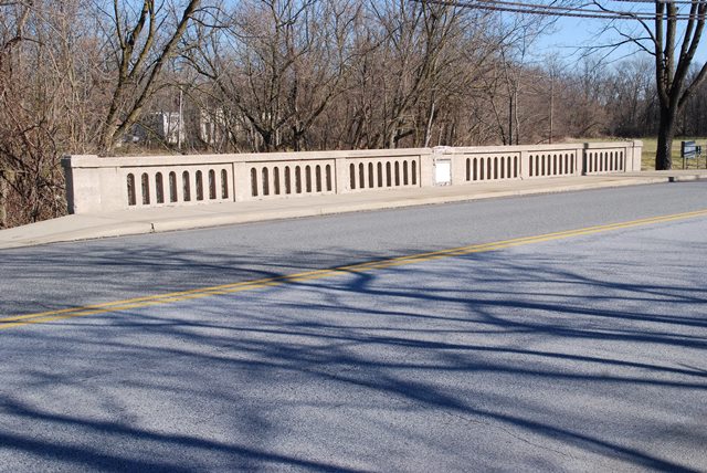
This bridge is an unaltered and typical example of a state standard plan concrete t-beam bridge. It has a state standard plaque. It also has a marble plaque from the previous stone arch bridge at this location mounted in it.
Information and Findings From Pennsylvania's Historic Bridge InventoryDiscussion of Bridge The 2 span, 64'-long T beam bridge built in 1934 has concrete balustrades and concrete pier, abutments, and wingwalls. The bridge was built by the state highway department using a standard design for T beam bridges. T beam bridges were built throughout the state from the late 1910s through the 1950s. The bridge is adjacent to the National Register-listed Roger Hunt mill complex, but is not within that property's boundaries. It postdates the mill complex's 18th- and 19th-century period of significance and is not significant in association with the mill. The bridge is not historically distinguished by its technology, setting or context. Discussion of Surrounding Area The bridge carries a 2 lane road and 2 sidewalks over a stream in north Downingtown. The bridge is over 500' upstream of the National Register-listed Roger Hunt Mill Complex (listed 1/4/1980), built in the 1740s and expanded in the 1850s-60s. The mill building has recently collapsed, but associated residences remain. The bridge is adjacent to but not within the boundaries of the property. At the bridge's southwest quadrant is a baseball field and at the southeast quadrant is an empty lot. Along US 322 to the northwest and southeast is a mix of undistinguished late-19th to late-20th-century residential and commercial buildings. The datestone of the previous bridge at this location is set in the bridge's downstream balustrade. Bridge Considered Historic By Survey: No |
![]()
![]()
![]()
Coordinates (Latitude, Longitude):
Search For Additional Bridge Listings:
Bridgehunter.com: View listed bridges within 0.5 miles (0.8 kilometers) of this bridge.
Bridgehunter.com: View listed bridges within 10 miles (16 kilometers) of this bridge.
Additional Maps:
Google Streetview (If Available)
GeoHack (Additional Links and Coordinates)
Apple Maps (Via DuckDuckGo Search)
Apple Maps (Apple devices only)
Android: Open Location In Your Map or GPS App
Flickr Gallery (Find Nearby Photos)
Wikimedia Commons (Find Nearby Photos)
Directions Via Sygic For Android
Directions Via Sygic For iOS and Android Dolphin Browser
USGS National Map (United States Only)
Historical USGS Topo Maps (United States Only)
Historic Aerials (United States Only)
CalTopo Maps (United States Only)

© Copyright 2003-2024, HistoricBridges.org. All Rights Reserved. Disclaimer: HistoricBridges.org is a volunteer group of private citizens. HistoricBridges.org is NOT a government agency, does not represent or work with any governmental agencies, nor is it in any way associated with any government agency or any non-profit organization. While we strive for accuracy in our factual content, HistoricBridges.org offers no guarantee of accuracy. Information is provided "as is" without warranty of any kind, either expressed or implied. Information could include technical inaccuracies or errors of omission. Opinions and commentary are the opinions of the respective HistoricBridges.org member who made them and do not necessarily represent the views of anyone else, including any outside photographers whose images may appear on the page in which the commentary appears. HistoricBridges.org does not bear any responsibility for any consequences resulting from the use of this or any other HistoricBridges.org information. Owners and users of bridges have the responsibility of correctly following all applicable laws, rules, and regulations, regardless of any HistoricBridges.org information.
![]()