

View Information About HSR Ratings
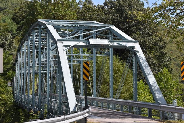
This notable pin-connected Parker truss bridge was lucky to receive a rehabilitation for continued vehicular use.

Information and Findings From Pennsylvania's Historic Bridge InventoryDiscussion of Bridge The one span, 228'-long, pin connected Parker thru truss bridge built in 1903 is supported on ashlar abutments. It is traditionally composed, but what stands out is its remarkable completeness. There are about 10 older Parker thru truss bridges throughout the state that are older than this example, including 3 in District 3-0, but the truss type is not common, this example is documented to a regional fabricator, and it has a long span length. The bridge is a historically and technologically significant example of the uncommon bridge type, which was used for longer spans because its design, developed in the 1870s, concentrates depth at the center of the span where forces are the greatest. Noteworthy features include the floorbeam framing, which reflects the transition from pinned to riveted field connections, and the railings. Discussion of Surrounding Area The single lane bridge carries a township road over a stream in a rural area with scattered residences. To the southeast of the bridge is a modern house, and to the southwest is a highly altered, 19th century house. To the north is SR 339 that has scattered, highly altered ca. 1900 houses. The area does not have the significance or integrity of a historic district. Bridge Considered Historic By Survey: Yes |
![]()
![]()
![]()
Coordinates (Latitude, Longitude):
Search For Additional Bridge Listings:
Bridgehunter.com: View listed bridges within 0.5 miles (0.8 kilometers) of this bridge.
Bridgehunter.com: View listed bridges within 10 miles (16 kilometers) of this bridge.
Additional Maps:
Google Streetview (If Available)
GeoHack (Additional Links and Coordinates)
Apple Maps (Via DuckDuckGo Search)
Apple Maps (Apple devices only)
Android: Open Location In Your Map or GPS App
Flickr Gallery (Find Nearby Photos)
Wikimedia Commons (Find Nearby Photos)
Directions Via Sygic For Android
Directions Via Sygic For iOS and Android Dolphin Browser
USGS National Map (United States Only)
Historical USGS Topo Maps (United States Only)
Historic Aerials (United States Only)
CalTopo Maps (United States Only)

© Copyright 2003-2024, HistoricBridges.org. All Rights Reserved. Disclaimer: HistoricBridges.org is a volunteer group of private citizens. HistoricBridges.org is NOT a government agency, does not represent or work with any governmental agencies, nor is it in any way associated with any government agency or any non-profit organization. While we strive for accuracy in our factual content, HistoricBridges.org offers no guarantee of accuracy. Information is provided "as is" without warranty of any kind, either expressed or implied. Information could include technical inaccuracies or errors of omission. Opinions and commentary are the opinions of the respective HistoricBridges.org member who made them and do not necessarily represent the views of anyone else, including any outside photographers whose images may appear on the page in which the commentary appears. HistoricBridges.org does not bear any responsibility for any consequences resulting from the use of this or any other HistoricBridges.org information. Owners and users of bridges have the responsibility of correctly following all applicable laws, rules, and regulations, regardless of any HistoricBridges.org information.
![]()