

View Information About HSR Ratings
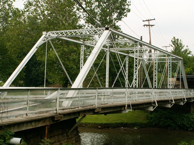
This truss bridge is located in a scenic, quiet area, with the small borough of Coal Center just to the west, and the Monongahela River to the north. This is a six panel Pratt through truss. It features some decorative detailing on the edges of the knee bracing of the portal. An 1888 date plaque survives, mounted at the end of the top chord where the end post begins. The bridge is an attractive pin connected structure, and features v-lacing on the vertical members, and lattice on the struts. If there was v-lacing or lattice under the top chord, it is gone now, since plates have been welded under the top chord. This is the most noticeable and substantial alteration to the bridge. Some of the floorbeams have been replaced as well, although original beams remain under the hip verticals. Speaking of hip verticals, this bridge has an unusual feature that tends to show up in older Penn Bridge Company bridges. There are actually two pins side by side at the top ends of the bridge, one for the top chord/endpost connection and another for the hip vertical/top chord connection.
Heading east, this bridge crosses Pike Run and then the road passes under a railroad overpass. Between this overpass and the narrow bridge, visibility is a bit on the low side, and you could see how a fender bender might happen if someone was not careful. Rather than foolishly wasting money and demolishing the bridge and overpass, Coal Center found a creative way to increase safety at this crossing. There is a sign before the bridge that reads "Sound Horn." Everyone gives a short honk of the horn before crossing the bridge, to let oncoming traffic no someone is coming. This represents a creative way to increase safety of the road, while not having to do anything real drastic. In a small community like Coal Center, this is likely more than enough to keep the bridge functional and safe.
Before reading the below review by the Historic Bridge Inventory, realize the survey was done in 1996, and so the other examples that they mention are quite likely no longer extant. A surviving 1888 truss bridge with even fair historic integrity should be considered significant today. The alteration on this bridge are either minimal, or something that could be removed as part of a bridge restoration.
Information and Findings From Pennsylvania's Historic Bridge InventoryDiscussion of Bridge The single-span, 103'-long, pin-connected Pratt through truss bridge built in 1888 is supported on ashlar abutments with wingwalls. The trusses are traditionally composed, and some of the original built up shaped floor beams remains. The three center ones have been replaced with rolled beams. There are some alterations. Cover plate has been welded to the bottom of the upper chords, and sidewalk has been added to one side by extending the floor beams. It is finished with a modern metal channel and mesh railing. The bridge is one of the oldest of its type in the county, which has a deep and varied collection of over 35 metal truss bridges from 1885 through the 1930s. Most are complete, and they represent the significance of the technology. In comparison with the county and regional population, this altered bridge is not historically or technologically significant. Discussion of Surrounding Area The bridge carries one lane of a two-lane road and a sidewalk over a stream east of the center of the borough of Coal Center. It is separated from the congested section by a vacant lot and a marina that is being developed. A railroad overpass of the Monongahela Railway is to the east. The area does not appear to have historic district potential. Bridge Considered Historic By Survey: No |
![]()
![]()
![]()
Coordinates (Latitude, Longitude):
Search For Additional Bridge Listings:
Bridgehunter.com: View listed bridges within 0.5 miles (0.8 kilometers) of this bridge.
Bridgehunter.com: View listed bridges within 10 miles (16 kilometers) of this bridge.
Additional Maps:
Google Streetview (If Available)
GeoHack (Additional Links and Coordinates)
Apple Maps (Via DuckDuckGo Search)
Apple Maps (Apple devices only)
Android: Open Location In Your Map or GPS App
Flickr Gallery (Find Nearby Photos)
Wikimedia Commons (Find Nearby Photos)
Directions Via Sygic For Android
Directions Via Sygic For iOS and Android Dolphin Browser
USGS National Map (United States Only)
Historical USGS Topo Maps (United States Only)
Historic Aerials (United States Only)
CalTopo Maps (United States Only)

© Copyright 2003-2024, HistoricBridges.org. All Rights Reserved. Disclaimer: HistoricBridges.org is a volunteer group of private citizens. HistoricBridges.org is NOT a government agency, does not represent or work with any governmental agencies, nor is it in any way associated with any government agency or any non-profit organization. While we strive for accuracy in our factual content, HistoricBridges.org offers no guarantee of accuracy. Information is provided "as is" without warranty of any kind, either expressed or implied. Information could include technical inaccuracies or errors of omission. Opinions and commentary are the opinions of the respective HistoricBridges.org member who made them and do not necessarily represent the views of anyone else, including any outside photographers whose images may appear on the page in which the commentary appears. HistoricBridges.org does not bear any responsibility for any consequences resulting from the use of this or any other HistoricBridges.org information. Owners and users of bridges have the responsibility of correctly following all applicable laws, rules, and regulations, regardless of any HistoricBridges.org information.
![]()