

View Information About HSR Ratings

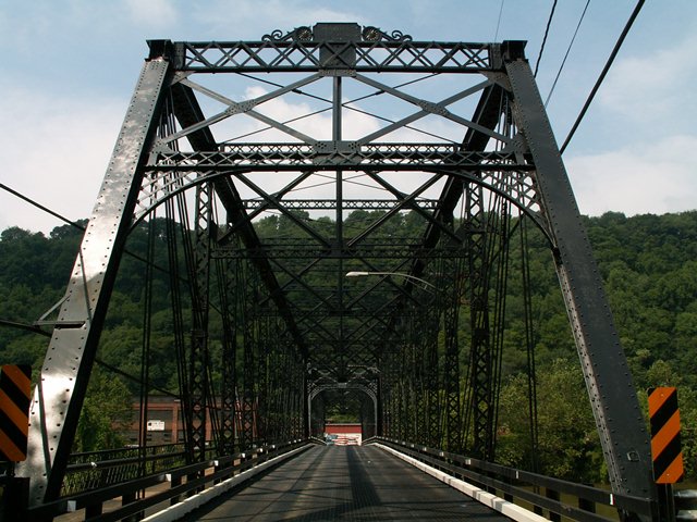
This highly significant historic bridge is a very large and old example of the Penn Bridge Company's work, located a short distance from the bridge company's home town of Beaver Falls. This rare multi-span Whipple truss bridge displays the same unusual double-pin detail at the ends of the top chord as found with smaller bridges built by the company during this period such as the Coal Center Bridge. As rare as Whipple truss bridges are today, multi-span Whipple truss bridges like this two span example are exceedingly rare. The bridge is also significant as one of the most important surviving examples of this noteworthy Pennsylvania-based bridge company.
The bridge has a cantilevered sidewalk present on the south side of the structure and the sidewalks retain original lattice railings. The railings curve away from the bridge at the ends and terminate in ornate cast iron end posts.
The bridge has carried a fairly large amount of traffic, but there are apparently ongoing efforts to build an additional bridge and new road over the Beaver River south of this bridge a ways, and it is expected that the majority of traffic that used the Fallston Bridge will instead use this new bridge, bringing the traffic volume on this historic bridge down to a more appropriate volume.
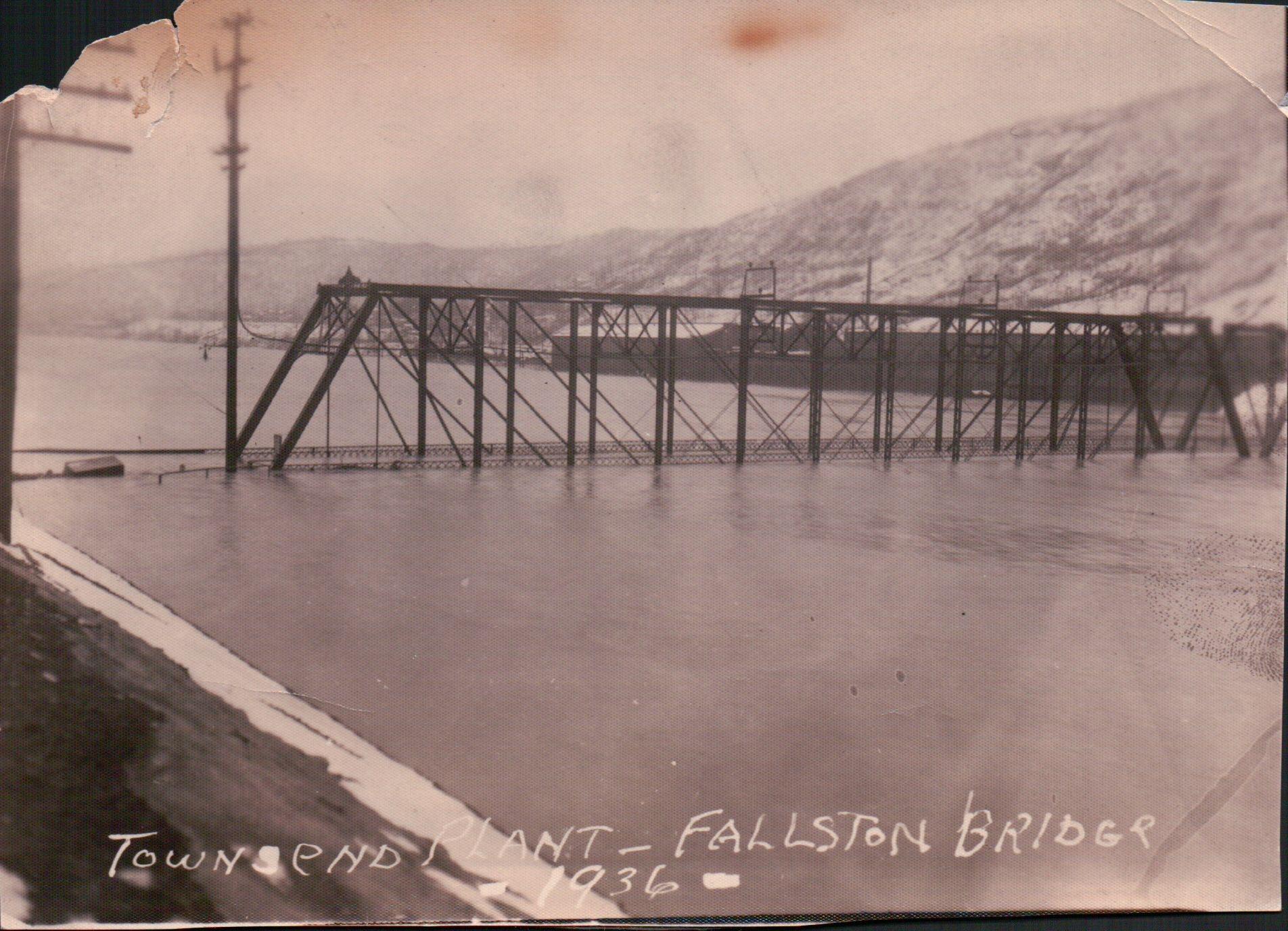
Above: Historical photo showing bridge during the 1936 flood.
Information and Findings From Pennsylvania's Historic Bridge InventoryDiscussion of Bridge The two-span, 406'-long, steel and/or iron double intersection Pratt (Whipple) through truss bridge, built in 1884. It was determined eligible as a result of the Section 106 consultation process. Discussion of Surrounding Area The Fallston Bridge carries a two-lane road over the Beaver River connecting the boroughs of Fallston and New Brighton. The intersection with SR 18 is at the east approach. Bridge Considered Historic By Survey: Yes |
![]()
![]()
![]()
Coordinates (Latitude, Longitude):
Search For Additional Bridge Listings:
Bridgehunter.com: View listed bridges within 0.5 miles (0.8 kilometers) of this bridge.
Bridgehunter.com: View listed bridges within 10 miles (16 kilometers) of this bridge.
Additional Maps:
Google Streetview (If Available)
GeoHack (Additional Links and Coordinates)
Apple Maps (Via DuckDuckGo Search)
Apple Maps (Apple devices only)
Android: Open Location In Your Map or GPS App
Flickr Gallery (Find Nearby Photos)
Wikimedia Commons (Find Nearby Photos)
Directions Via Sygic For Android
Directions Via Sygic For iOS and Android Dolphin Browser
USGS National Map (United States Only)
Historical USGS Topo Maps (United States Only)
Historic Aerials (United States Only)
CalTopo Maps (United States Only)

© Copyright 2003-2024, HistoricBridges.org. All Rights Reserved. Disclaimer: HistoricBridges.org is a volunteer group of private citizens. HistoricBridges.org is NOT a government agency, does not represent or work with any governmental agencies, nor is it in any way associated with any government agency or any non-profit organization. While we strive for accuracy in our factual content, HistoricBridges.org offers no guarantee of accuracy. Information is provided "as is" without warranty of any kind, either expressed or implied. Information could include technical inaccuracies or errors of omission. Opinions and commentary are the opinions of the respective HistoricBridges.org member who made them and do not necessarily represent the views of anyone else, including any outside photographers whose images may appear on the page in which the commentary appears. HistoricBridges.org does not bear any responsibility for any consequences resulting from the use of this or any other HistoricBridges.org information. Owners and users of bridges have the responsibility of correctly following all applicable laws, rules, and regulations, regardless of any HistoricBridges.org information.
![]()