

View Information About HSR Ratings
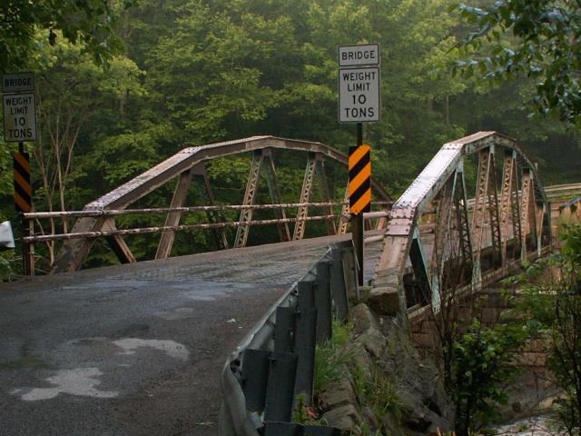
This is a bridge where even with any historic significance set aside, should be preserved for its aesthetic value. Its pleasant arch shape, coupled with attractive v-lacing on some members make this a beautiful bridge. In addition, Slippery Rock Creek is indeed filled with rocks, and this bridges location near some mill ruins makes this a very scenic area. The old mill ruins has left a rapids-like feature in the river.
This is a polygonal Warren pony truss with no vertical members. It is supported by stone abutments. Original pole railings remain on the bridge. There is v-lacing on some diagonals. This bridge was designed by Thomas Gilkey, an engineer who designed a wide variety of truss structures for Lawrence County, including the newer span of the Churchill Road Bridge, and the Mahoning Avenue Viaduct. Gilkey traditionally favored pin connections, even into the 1910s, but apparently by the 1920s he gave them up and switched to riveted connections as seen on this bridge. This bridge was a good example of a bridge designed by a local engineer who did a substantial amount of bridge work in the local area.
![]()
![]()
![]()
This historic bridge has been demolished. This map is shown for reference purposes only.
Coordinates (Latitude, Longitude):
Search For Additional Bridge Listings:
Bridgehunter.com: View listed bridges within 0.5 miles (0.8 kilometers) of this bridge.
Bridgehunter.com: View listed bridges within 10 miles (16 kilometers) of this bridge.
Additional Maps:
Google Streetview (If Available)
GeoHack (Additional Links and Coordinates)
Apple Maps (Via DuckDuckGo Search)
Apple Maps (Apple devices only)
Android: Open Location In Your Map or GPS App
Flickr Gallery (Find Nearby Photos)
Wikimedia Commons (Find Nearby Photos)
Directions Via Sygic For Android
Directions Via Sygic For iOS and Android Dolphin Browser
USGS National Map (United States Only)
Historical USGS Topo Maps (United States Only)
Historic Aerials (United States Only)
CalTopo Maps (United States Only)

© Copyright 2003-2024, HistoricBridges.org. All Rights Reserved. Disclaimer: HistoricBridges.org is a volunteer group of private citizens. HistoricBridges.org is NOT a government agency, does not represent or work with any governmental agencies, nor is it in any way associated with any government agency or any non-profit organization. While we strive for accuracy in our factual content, HistoricBridges.org offers no guarantee of accuracy. Information is provided "as is" without warranty of any kind, either expressed or implied. Information could include technical inaccuracies or errors of omission. Opinions and commentary are the opinions of the respective HistoricBridges.org member who made them and do not necessarily represent the views of anyone else, including any outside photographers whose images may appear on the page in which the commentary appears. HistoricBridges.org does not bear any responsibility for any consequences resulting from the use of this or any other HistoricBridges.org information. Owners and users of bridges have the responsibility of correctly following all applicable laws, rules, and regulations, regardless of any HistoricBridges.org information.
![]()