We Recommend:
Bach Steel - Experts at historic truss bridge restoration.
Nebraska Bridge
Primary Photographer(s): Nathan Holth
Bridge Documented: July 1, 2006
Nebraska (Rural): Forest County, Pennsylvania: United States
1933 By Builder/Contractor: Ortale Construction Company and Engineer/Design: Pennsylvania State Highway Department
1999
184.0 Feet (56.1 Meters)
187.0 Feet (57 Meters)
23.3 Feet (7.1 Meters)
1 Main Span(s)
273004015000000

View Information About HSR Ratings
Bridge Documentation
More information available on the Pennsylvania Wilds website.
View Archived National Bridge Inventory Report - Has Additional Details and Evaluation

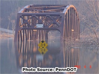
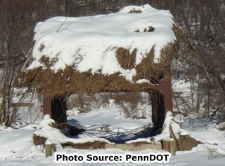
This bridge will soon be the only truss bridge in all of Forest County. This bridge is also noted for annually being flooded well above the deck, making this a "seasonal" crossing to say the least. The flood waters that this bridge receives are due to a nearby dam. As such, the flood waters are not raging floodwaters that carry a truss bridge off its abutments and crush it into scrap metal downstream, but are instead more or less calm and just drown the bridge. Water levels have risen high enough such that the entire bridge was underwater. In one of these cases, after the water level dropped, a bunch of debris that was floating on the water was left on top of the truss.
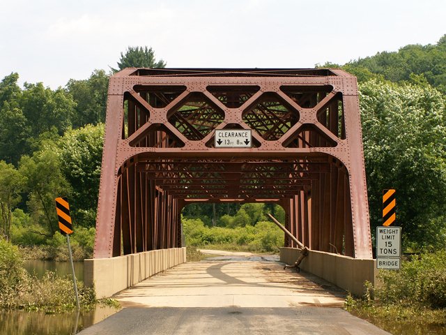
Beyond being the submersible bridge, this is a good example of a standard plan massive-member Parker truss in Pennsylvania. Givens its rather rural location, HistoricBridges.org does not see its flooding problem to be enough reason to demolish the bridge. Although it is posted for a 15 ton weight limit, the bridge appeared to be in decent shape.
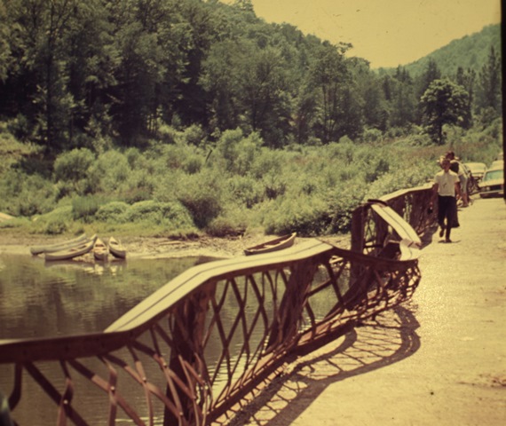
The historic bridge inventory says that the bridge is closed. It appears to only be closed when flooded out, otherwise you can drive across the bridge. HistoricBridges.org also saw no evidence of a sidewalk, or lattice railing. It turns out that there used to be a sidewalk, but all the flooding damaged the railing, and given its rural location it was probably easier to simply remove the sidewalk.
Above: Historical photo from 1966 showing the damaged sidewalk. Photo Credit: Margery Boyle
Information and Findings From Pennsylvania's Historic Bridge InventoryDiscussion of Bridge The 1933, riveted, single span, 187'-long, Parker thru truss bridge is supported on concrete abutments with flared wingwalls. The trusses have built up upper and lower chords and rolled section verticals and diagonals. A portion of the sidewalk has been lost, and its lattice railing has been significantly damaged. The bridge, built to a state highway department standard design used with great frequency since the mid 1920s, has no innovative or distinctive details. An undistinguished example of its technology, the bridge is neither historically nor technologically significant. Discussion of Surrounding Area The bridge carries a 2 lane road and sidewalk over a stream that is part of the Tionesta Lake flood control impounding area. The dam is approximately 4 miles upstream. The water level is just before the bridge deck, and the bridge is currently closed to all traffic. The setting is forested and sparsely developed, and does not have historic district potential. Bridge Considered Historic By Survey: No |
![]()
Photo Galleries and Videos: Nebraska Bridge
Bridge Photo-Documentation
Original / Full Size PhotosA collection of overview and detail photos. This gallery offers photos in the highest available resolution and file size in a touch-friendly popup viewer.
Alternatively, Browse Without Using Viewer
![]()
Bridge Photo-Documentation
Mobile Optimized PhotosA collection of overview and detail photos. This gallery features data-friendly, fast-loading photos in a touch-friendly popup viewer.
Alternatively, Browse Without Using Viewer
![]()
Maps and Links: Nebraska Bridge
Coordinates (Latitude, Longitude):
Search For Additional Bridge Listings:
Bridgehunter.com: View listed bridges within 0.5 miles (0.8 kilometers) of this bridge.
Bridgehunter.com: View listed bridges within 10 miles (16 kilometers) of this bridge.
Additional Maps:
Google Streetview (If Available)
GeoHack (Additional Links and Coordinates)
Apple Maps (Via DuckDuckGo Search)
Apple Maps (Apple devices only)
Android: Open Location In Your Map or GPS App
Flickr Gallery (Find Nearby Photos)
Wikimedia Commons (Find Nearby Photos)
Directions Via Sygic For Android
Directions Via Sygic For iOS and Android Dolphin Browser
USGS National Map (United States Only)
Historical USGS Topo Maps (United States Only)
Historic Aerials (United States Only)
CalTopo Maps (United States Only)

