

View Information About HSR Ratings
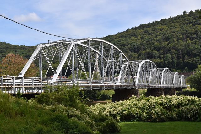
This is a rare surviving multi-span example of a lightweight pin-connected Parker through truss, and one of the last known surviving pre-1900 highway bridges over one of the biggest rivers in Pennsylvania. This is not the original location of the bridge. It was originally built to carry Carey Avenue over the Susquehanna River at Plymouth, Pennsylvania. In this previous location an island is present in the river, so the bridge had two truss spans over one side of the island and three truss spans over the other side. In 1948 when the Carey Avenue Bridge was replaced, the trusses were salvaged and after a few years a project to move them here at what was then the Retreat Hospital was completed. The relocation project was completed and the bridge dedicated in September 1951. Portions of the substructure may have been reused as well, as the bridge has stone piers in its current location, and there was not a previous bridge at this location (nor was stone normally used in the mid 20th century). Back at Plymouth, the 1948 bridge that replaced this bridge was a rivet-connected truss bridge. It too was replaced, but by then PennDOT was in charge and as a result the 1948 trusses were sent straight to the dumpster. It is ironic that this 1895 bridge has even outlived its 1948 replacement.
Don't let the pleasant sounding name fool you: this bridge doesn't lead to a vacation retreat, it leads to the State Correctional Institution at Retreat... a prison... and the prison is the only facility on the other side of the bridge. It is owned by the Department of Corrections. Walking on the bridge is therefore not advised. However, the prison was slated to be closed in June 2020 (or some unknown time after), so it is unclear whether that will make it easier to walk on the bridge, or if the bridge will be fenced off, or even worse, demolished. Whenever the prison is fully closed it is expected that bridge, prison, and property would be auctioned off and the fate of the bridge would be decided by any potential new owner. Reportedly, the bridge recieved $2,000,000 in repairs prior to closure of the prison. As of 2022, the county is considering converting the facility to a county prison. This is not the sort of change that would be conducive to making this historic bridge accessible to the public. The news article offered some history of the facility:
"Central Poor District of Luzerne County established an almshouse for the indigent there in 1878. A hospital for those with mental health conditions was added in 1900. The property was known as the Retreat Hospital for the Insane and Almshouse for 30 years and renamed the Retreat Mental Hospital in 1930. The county operated that facility until 1943, when it was transferred to state control. The hospital formally closed in 1981, and it opened as a state prison in January 1988."
The facility's most recent name was the Retreat State Hospital prior to becoming a prison in the 1980s. As a hospital, it originally had no bridge and boats were used to access the facility.
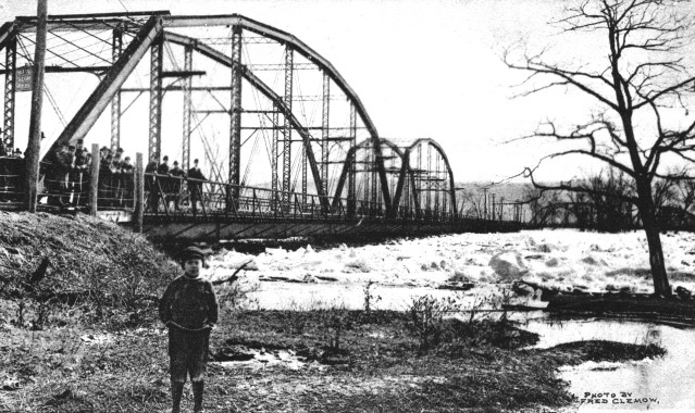
Above: Historical photo showing bridge in previous location at Carey Avenue, Plymouth. Only two spans are visible because the bridge crossed at an island here, so the spans were not all together in this location.
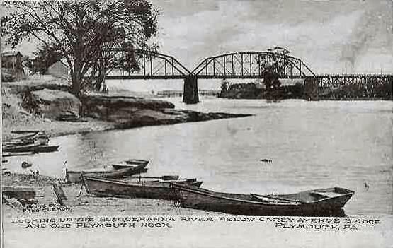
Above: Historical photo showing bridge in previous location at Carey Avenue, Plymouth. Only two spans are visible because the bridge crossed at an island here, so the spans were not all together in this location.
Information and Findings From Pennsylvania's Historic Bridge InventoryDiscussion of Bridge The 7-span, 1,205'-long, pin-connected Parker steel thru truss bridge has been determined eligible by PHMC (DOE 1/10/95). According to PHMC records, the bridge was originally located about 5 miles upstream. It was moved to this location ca. 1930. Discussion of Surrounding Area The bridge carries a 1 lane road and sidewalk over a stream. The bridge is the entrance to the Retreat State Correctional Instistute. Bridge Considered Historic By Survey: Yes |
![]()
![]()
![]()
This bridge leads to a prison, and the prison is the only facility on the other side of the bridge. It is basically a part of the prison. Walking on the bridge is therefore not advised.
Coordinates (Latitude, Longitude):
Search For Additional Bridge Listings:
Bridgehunter.com: View listed bridges within 0.5 miles (0.8 kilometers) of this bridge.
Bridgehunter.com: View listed bridges within 10 miles (16 kilometers) of this bridge.
Additional Maps:
Google Streetview (If Available)
GeoHack (Additional Links and Coordinates)
Apple Maps (Via DuckDuckGo Search)
Apple Maps (Apple devices only)
Android: Open Location In Your Map or GPS App
Flickr Gallery (Find Nearby Photos)
Wikimedia Commons (Find Nearby Photos)
Directions Via Sygic For Android
Directions Via Sygic For iOS and Android Dolphin Browser
USGS National Map (United States Only)
Historical USGS Topo Maps (United States Only)
Historic Aerials (United States Only)
CalTopo Maps (United States Only)

© Copyright 2003-2024, HistoricBridges.org. All Rights Reserved. Disclaimer: HistoricBridges.org is a volunteer group of private citizens. HistoricBridges.org is NOT a government agency, does not represent or work with any governmental agencies, nor is it in any way associated with any government agency or any non-profit organization. While we strive for accuracy in our factual content, HistoricBridges.org offers no guarantee of accuracy. Information is provided "as is" without warranty of any kind, either expressed or implied. Information could include technical inaccuracies or errors of omission. Opinions and commentary are the opinions of the respective HistoricBridges.org member who made them and do not necessarily represent the views of anyone else, including any outside photographers whose images may appear on the page in which the commentary appears. HistoricBridges.org does not bear any responsibility for any consequences resulting from the use of this or any other HistoricBridges.org information. Owners and users of bridges have the responsibility of correctly following all applicable laws, rules, and regulations, regardless of any HistoricBridges.org information.
![]()