

View Information About HSR Ratings
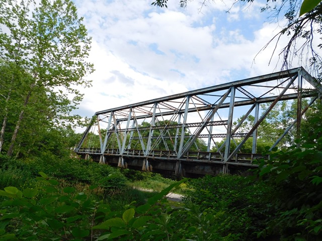
This is a former railroad bridge that was converted for one-lane vehicular use. The bridge uses cast iron caps for the pins, an unusual detail for a railroad bridge.
Information and Findings From Pennsylvania's Historic Bridge InventoryDiscussion of Bridge The one span, 165'-long, pin connected Pratt thru truss bridge is supported on one stone and one concrete abutment. The deep, heavy trusses have many hallmarks of railroad construction including built up Z section for the verticals and eye bar packs for the lower chords. Deep, built up floorbeams are suspended from the lower panel point pins, and they support 2 lines of riveted stringers, which were located to support the original track lines. The bridge is one of the few surviving resources related to Sayre's historical development as the largest shop complex on the entire Lehigh Valley Railroad system. Technologically it represents the type of span constructed by the railroads in response to advances in bridge design and metallurgy in the mid 1880s, and it is historically and technologically significant. Discussion of Surrounding Area The single lane bridge carries a township road over a stream in an industrial area east of Sayre. Opposing traffic flow is controlled by a signal. The setting does not appear to have historic district potential. Until 1976, it carried a Lehigh Valley Railroad spur line to connect with the Delaware & Hudson Railroad. After the Conrail merger, the roadbed was converted to a vehicular road. Bridge Considered Historic By Survey: Yes |
![]()
![]()
![]()
Coordinates (Latitude, Longitude):
Search For Additional Bridge Listings:
Bridgehunter.com: View listed bridges within 0.5 miles (0.8 kilometers) of this bridge.
Bridgehunter.com: View listed bridges within 10 miles (16 kilometers) of this bridge.
Additional Maps:
Google Streetview (If Available)
GeoHack (Additional Links and Coordinates)
Apple Maps (Via DuckDuckGo Search)
Apple Maps (Apple devices only)
Android: Open Location In Your Map or GPS App
Flickr Gallery (Find Nearby Photos)
Wikimedia Commons (Find Nearby Photos)
Directions Via Sygic For Android
Directions Via Sygic For iOS and Android Dolphin Browser
USGS National Map (United States Only)
Historical USGS Topo Maps (United States Only)
Historic Aerials (United States Only)
CalTopo Maps (United States Only)

© Copyright 2003-2024, HistoricBridges.org. All Rights Reserved. Disclaimer: HistoricBridges.org is a volunteer group of private citizens. HistoricBridges.org is NOT a government agency, does not represent or work with any governmental agencies, nor is it in any way associated with any government agency or any non-profit organization. While we strive for accuracy in our factual content, HistoricBridges.org offers no guarantee of accuracy. Information is provided "as is" without warranty of any kind, either expressed or implied. Information could include technical inaccuracies or errors of omission. Opinions and commentary are the opinions of the respective HistoricBridges.org member who made them and do not necessarily represent the views of anyone else, including any outside photographers whose images may appear on the page in which the commentary appears. HistoricBridges.org does not bear any responsibility for any consequences resulting from the use of this or any other HistoricBridges.org information. Owners and users of bridges have the responsibility of correctly following all applicable laws, rules, and regulations, regardless of any HistoricBridges.org information.
![]()