

View Information About HSR Ratings
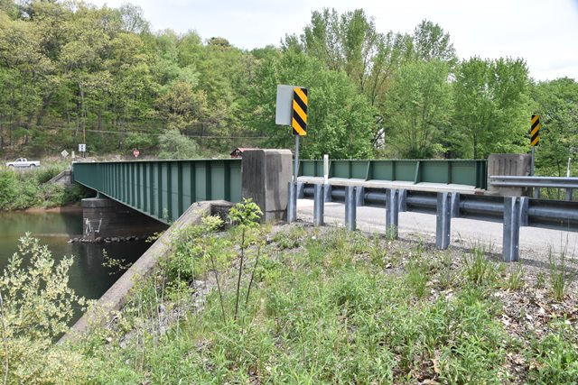
This is an excellent example of a highway plate girder bridge that stands out for its lack of alteration. While the Historic Bridge Inventory dismissed most if not all plate girders as not historic, unaltered examples like this should be singled out as historically significance given the number of these bridges that have been altered or demolished. Often these girders lack plaques or have had barriers added to the interior of the girders.
Information and Findings From Pennsylvania's Historic Bridge InventoryDiscussion of Bridge The 1938, 2 simple span, built-up steel girder bridge is supported on horizontally scored concrete abutments with wingwalls and a cutwater pier. The bridge also has steel floorbeams and a reinforced concrete deck. The bridge is an example of a common type built by the railroad industry since the 1850s and used on vehicular highways since the late 19th century. The bridge has no innovative or distinguishing features, and is a comparatively late example of its type. Neither the bridge nor its setting or context is historically or technologically noteworthy. Discussion of Surrounding Area The bridge carries a 2 lane road over a stream in a sparsely developed, rural area with scattered early and middle 20th century residences. There is a T intersection just after the bridge. Bridge Considered Historic By Survey: No |
![]()
![]()
![]()
Coordinates (Latitude, Longitude):
Search For Additional Bridge Listings:
Bridgehunter.com: View listed bridges within 0.5 miles (0.8 kilometers) of this bridge.
Bridgehunter.com: View listed bridges within 10 miles (16 kilometers) of this bridge.
Additional Maps:
Google Streetview (If Available)
GeoHack (Additional Links and Coordinates)
Apple Maps (Via DuckDuckGo Search)
Apple Maps (Apple devices only)
Android: Open Location In Your Map or GPS App
Flickr Gallery (Find Nearby Photos)
Wikimedia Commons (Find Nearby Photos)
Directions Via Sygic For Android
Directions Via Sygic For iOS and Android Dolphin Browser
USGS National Map (United States Only)
Historical USGS Topo Maps (United States Only)
Historic Aerials (United States Only)
CalTopo Maps (United States Only)

© Copyright 2003-2024, HistoricBridges.org. All Rights Reserved. Disclaimer: HistoricBridges.org is a volunteer group of private citizens. HistoricBridges.org is NOT a government agency, does not represent or work with any governmental agencies, nor is it in any way associated with any government agency or any non-profit organization. While we strive for accuracy in our factual content, HistoricBridges.org offers no guarantee of accuracy. Information is provided "as is" without warranty of any kind, either expressed or implied. Information could include technical inaccuracies or errors of omission. Opinions and commentary are the opinions of the respective HistoricBridges.org member who made them and do not necessarily represent the views of anyone else, including any outside photographers whose images may appear on the page in which the commentary appears. HistoricBridges.org does not bear any responsibility for any consequences resulting from the use of this or any other HistoricBridges.org information. Owners and users of bridges have the responsibility of correctly following all applicable laws, rules, and regulations, regardless of any HistoricBridges.org information.
![]()