We Recommend:
Bach Steel - Experts at historic truss bridge restoration.
BridgeHunter.com Phase 1 is released to the public! - Visit Now
New Richmond Bridge
57th Street Bridge

Primary Photographer(s): Nathan Holth and Rick McOmber
Bridge Documented: April 28, 2006 - June 30, 2018
New Richmond: Allegan County, Michigan: United States
Metal Pin-Connected Warren Pony Truss, Movable: Swing (Center Pier) and Approach Spans: Metal Warren Pony Truss, Fixed
1879 By Builder/Contractor: Milwaukee Bridge and Iron Works of Milwaukee, Wisconsin
2005
72.0 Feet (21.9 Meters)
422.0 Feet (128.6 Meters)
11.8 Feet (3.6 Meters)
1 Main Span(s) and 9 Approach Span(s)
03314H00020B010

View Information About HSR Ratings
Bridge Documentation
View Archived National Bridge Inventory Report - Has Additional Details and Evaluation
Visit Allegan County's Website For The Development of a Park Around The Bridge
Click here to view a PDF showing Allegan County's master plan for the park.
About This Bridge
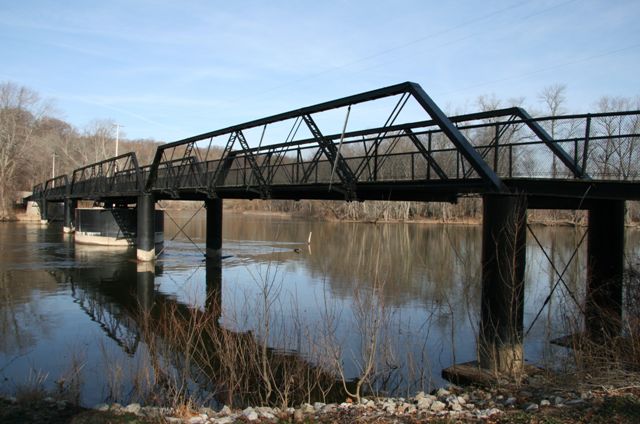
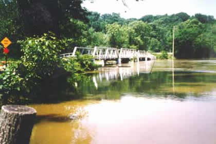
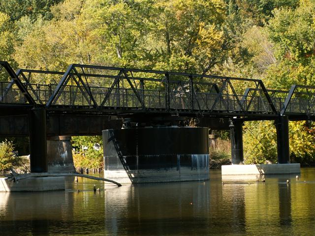
This nationally significant bridge is one of the top historic bridges in Michigan. Multi-span pony truss bridges are uncommon, and this four-span structure is the longest remaining pony truss in Michigan. Pin-connected Warren truss bridges like this bridge are very rare both in Michigan and nationwide. The 1879 construction date makes this one of the oldest truss bridges in Michigan. Additionally, pre-1880 metal bridges are extremely rare nationwide. Each surviving example should be considered to have a high level of historic significance due to their rarity and also the fact that bridges from this period show a lack of standardization and reveal the early development of metal bridge construction in the country. The early date of construction is evident in the unusual design of the built-up members and chords on the bridge, which are unlike the standards found in most truss bridges of the 1880s and 1890s. In particular, built-up diagonal members are an unusual design with a corrugated lacing (called ribbon lacing in some sources). In addition, the outriggers have star iron, a unique type of rolled structural iron that was common in the 1870s but not after. The swing span has some different features than the approach spans also. Diagonal members and top chords are different in size for instance, reflecting the alternating forces of tension and compression in a Warren truss. The built-up top chord on the swing span is an unusual design. One of the approach spans was replaced in 1899. This span is in itself significant. It is constructed in the lightweight style similar to the 10 Mile Road Bridge, a design of which few remaining examples exist. With an 1899 construction date, this pony truss replacement is also historically significant as an early example of a highway truss using riveted connections. It may be the earliest highway example in Michigan.
The last noteworthy repair of this bridge for highway traffic was in 1980. In 2005, this bridge was restored for pedestrian use only, representing an excellent success story for Michigan and historic bridges in general. The bridge was dismantled and the parts were repaired off-site before being returned to the site for reassembly. The bridge was restored in-kind and rivets were replaced with rivets, something that should be done automatically, however many states replace rivets with bolts, so this practice is worth mentioning. Although the Kalamazoo River is no longer navigable for boats, the restoration still included restoring the mechanics that allow this manually turned swing bridge to operate. An opening ceremony took place in which the bridge was opened and closed.
The only disappointment for the restoration, is the choice of cyclone fencing railings. Granted, liability and safety are a concern, but there are other safe alternatives that also more attractive, such as the pole railings seen on the pedestrian bridge in downtown Grand Rapids.
The Park
This bridge today is the centerpiece of New Richmond Bridge Park. This county park features a boat launch and parking lot on the north side of the bridge. A boardwalk/trail leads to the bridge on this side as well as under the northern approach spans of the bridge. The location appears to be a popular fishing site. On the southern side of the bridge, the boardwalk/trail continues on in a scenic loop. Interpretive signage and plaques are scattered throughout the park as well. Entry to the park is free. These signs and plaques discuss the significance of the bridge, New Richmond, the river, the railroad line, and nearby wildlife. This park is a wonderful example of how a bridge preserved in place for pedestrian use only can be more than just a pedestrian crossing, but can also be much more, in the case, the anchor for a signature park.
Information and Findings From Michigan Historic Bridge InventoryNarrative Description
The Kalamazoo River was navigable from Lake Michigan well inland until the late 1920s. The New Richmond Bridge, which consists of four spans and measures 429 feet in length, had a manually-turned swing span which was
still in service as late as 1925. The bridge spans the Kalamazoo River at a broad loop where its course turns from northwest to southwest on its way toward Lake Michigan a few miles to the west. This is one of Michigan's oldest metal
truss highway bridge and the largest by far in overall length of Michigan's pony truss highway bridges. The bridge's chief importance, however, is that it is one of the oldest - if not the oldest - surviving highway swing bridges in
the United States. Information and Findings From Michigan Historic Sites OnlineNarrative Description The New Richmond Bridge is a 422 foot long highway bridge spanning the Kalamazoo River on 57th Street near the village of New Richmond. The structure is comprised of four primary spans, each a Warren truss of wrought iron, with a wood-planked deck. The primary spans include an eighty-nine-foot long Warren pony truss equal-arm swing span, a Warren pony truss span seventy feet long on either side of the swing span -- all three spans constructed with pinned connections -- and a fifty foot nine inches long riveted Warren pony truss to the north of the more northerly seventy-foot pony truss span. The structure has a minimum roadway width of twelve feet ten inches. The New Richmond Bridge's three pinned Warren truss spans date from 1879, the riveted Warren span from 1899. The bridge spans the Kalamazoo River at a broad loop where its course turns from northwest to southwest on its way toward Lake Michigan a few miles to the west. The mostly wooded site is a bucolic one, with the small hamlet of New Richmond a short distance on the low ground to the south and hills rising steeply just to the north. A plate girder railroad bridge spans the river at a shallow angle to the New Richmond Bridge a short distance west. Statement of Significance With its three 1879 spans fabricated by the Milwaukee Bridge and Iron Company, the New Richmond Bridge is one of Michigan's oldest metal truss highway bridges and the largest by far in overall length of Michigan's pony truss highway bridges. The bridge's chief importance, however, is that it is one of the oldest -- if not the oldest -- surviving highway swing bridges in the United States. The erection of the bridge generated considerable local controversy, as residents opposed to the high cost of an iron structure attempted to halt construction by dislodging piles. The bridge is now being rehabilitated through public funding and private subscription. It was inventoried by the Historic American Engineering Record in 1975, and was described as "an excellent example of late nineteenth-century bridge construction." |
This bridge is tagged with the following special condition(s): Unorganized Photos
![]()
Photo Galleries and Videos: New Richmond Bridge
2010-2012 Bridge Photo-Documentation
Original / Full Size PhotosA collection of overview and detail photos, with a focus on bridge overview photos, interpretive signage, and the park ground. This gallery offers photos in the highest available resolution and file size in a touch-friendly popup viewer.
Alternatively, Browse Without Using Viewer
![]()
2010-2012 Bridge Photo-Documentation
Mobile Optimized PhotosA collection of overview and detail photos, with a focus on bridge overview photos, interpretive signage, and the park ground. This gallery features data-friendly, fast-loading photos in a touch-friendly popup viewer.
Alternatively, Browse Without Using Viewer
![]()
2006 Bridge Photo-Documentation
With a focus on detail photos, this is also a collection of overview photos taken shortly after the bridge was restored. This photo gallery contains a combination of Original Size photos and Mobile Optimized photos in a touch-friendly popup viewer.Alternatively, Browse Without Using Viewer
![]()
Additional Unorganized Photos
Original / Full Size PhotosA supplemental collection of photos that are from additional visit(s) to the bridge and have not been organized or captioned. This gallery offers photos in the highest available resolution and file size in a touch-friendly popup viewer.
Alternatively, Browse Without Using Viewer
![]()
Additional Unorganized Photos
Mobile Optimized PhotosA supplemental collection of photos that are from additional visit(s) to the bridge and have not been organized or captioned. This gallery features data-friendly, fast-loading photos in a touch-friendly popup viewer.
Alternatively, Browse Without Using Viewer
![]()
Maps and Links: New Richmond Bridge
Coordinates (Latitude, Longitude):
Search For Additional Bridge Listings:
Bridgehunter.com: View listed bridges within 0.5 miles (0.8 kilometers) of this bridge.
Bridgehunter.com: View listed bridges within 10 miles (16 kilometers) of this bridge.
Additional Maps:
Google Streetview (If Available)
GeoHack (Additional Links and Coordinates)
Apple Maps (Via DuckDuckGo Search)
Apple Maps (Apple devices only)
Android: Open Location In Your Map or GPS App
Flickr Gallery (Find Nearby Photos)
Wikimedia Commons (Find Nearby Photos)
Directions Via Sygic For Android
Directions Via Sygic For iOS and Android Dolphin Browser
USGS National Map (United States Only)
Historical USGS Topo Maps (United States Only)
Historic Aerials (United States Only)
CalTopo Maps (United States Only)


