
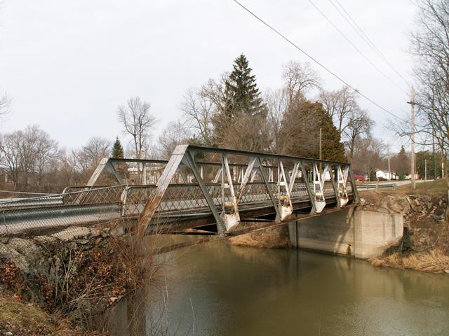

View Information About HSR Ratings
This was one of the nicest examples of a Warren pony truss riveted connections in Michigan. There once were many bridges of this type in the Thumb of Michigan, distinguished by their trusses that were composed of paired angles, with none of the heavier channels often found on riveted truss bridges. Few remain today. This particular bridge's skewed design added interest and significance to the bridge as it was a rare example of this design in a skewed format. The lattice railing were original, and were intact. When documented in 2005, the bridge was in decent condition, and even had paint on it, unlike many truss bridges in Michigan. This bridge was is also interesting because it was in an urban setting, albeit a small town. Most of these bridges that survived were located in rural areas. Actually, this part of Sebewaing may have been rural when this bridge was built, based on its location in the town and the age of the nearby houses. According to MDOT, this bridge was built in 1902, and is 90 feet long. This made it a very old example of a rivet-connected truss bridge in Michigan, and among the longest pony truss spans in Michigan. This bridge was listed on the National Register of Historic Places.
The deck of the bridge was concrete with a layer of asphalt on top for a wearing surface. The concrete underneath the bridge looked old, but the concrete on top, which is visible near the edges of the bridge deck, appeared to be fairly new. This suggested that the deck was repaired, but not completely replaced, at some point in time. It is not known if the old part of the concrete deck was original or merely old. Some of these paired angle pony truss bridges were built with jack-arch decks, which this bridge does not have, which might suggest that the deck was not original, just old. It is known that the Army Corps of Engineers rebuilt the abutments in 1948, and the bridge was painted in 1986.
Significant deterioration of the bridge was mostly confined to the outermost deck stringers, and the ends of the floor beams, and perhaps some deterioration around the bottom chord connections. This was confirmed both by site visit and review of an official bridge inspection report. These are all traditional areas where deterioration first forms. Otherwise, the truss was in good condition. This would have been an outstanding bridge to rehabilitate, since it was still in fair condition, is on a lightly traveled residential street, and is in a location where many people could easily enjoy the bridge. The Michigan Historic Bridge Inventory of 1995 listed several other pony trusses on public roads in the western Huron County area, all of which have been replaced by slabs of concrete. This was all the more reason to save the Anton Street Bridge.
Instead, with the support of MDOT, Sebewaing opted to waste 1.4 Million taxpayer dollars demolishing and replacing the bridge in 2013. This was a huge waste of tax dollars and a waste of heritage. This bridge could easily have been rehabilitated, likely for less than the cost of replacement. At most, the only things on the bridge that needed to be replaced would be the deck, floor beams, and deck stringers. The trusses could have simply been repaired. The city claimed that a new, wider bridge would be safer. This is ridiculous. The historic bridge was the same width as the city street. If someone were to park on the street, as is common on a city street, the approaching roadway would be made even more narrow. A wider bridge is a waste of materials. As a city street, speeds should be low, and nearly all traffic would have been light weight passenger cars and pickup trucks. The historic bridge was both safe and functional for the residential street. If trucks needed to cross the river, they would obviously not need to use this bridge and could instead use the state trunkline bridge located a mere 1/3 mile west of this bridge. This bridge was replaced using MDOT's Local Bridge Program. This program was supposed to be an improvement over previous programs because it also funds rehabilitation and repair in addition to replacement. However, this program has been a failure since local agencies rarely request rehab funds, and instead request funds for more costly replacement funds, and MDOT fails to show restraint (by asking local agencies to consider rehab instead) and approves the replacement funding. So nothing has been changed. Worse, the Local Bridge Program only uses state funds, allowing MDOT and the local agency to skip the Section 106 Review which is a federal program designed to protect historic bridges that are feasible and prudent to rehabilitate from demolition. If federal funds were used like most states use, Section 106 would have applied to this bridge replacement project.
![]()
![]()
![]()
This historic bridge has been demolished. This map is shown for reference purposes only.
Coordinates (Latitude, Longitude):
Search For Additional Bridge Listings:
Bridgehunter.com: View listed bridges within 0.5 miles (0.8 kilometers) of this bridge.
Bridgehunter.com: View listed bridges within 10 miles (16 kilometers) of this bridge.
Additional Maps:
Google Streetview (If Available)
GeoHack (Additional Links and Coordinates)
Apple Maps (Via DuckDuckGo Search)
Apple Maps (Apple devices only)
Android: Open Location In Your Map or GPS App
Flickr Gallery (Find Nearby Photos)
Wikimedia Commons (Find Nearby Photos)
Directions Via Sygic For Android
Directions Via Sygic For iOS and Android Dolphin Browser
USGS National Map (United States Only)
Historical USGS Topo Maps (United States Only)
Historic Aerials (United States Only)
CalTopo Maps (United States Only)

© Copyright 2003-2024, HistoricBridges.org. All Rights Reserved. Disclaimer: HistoricBridges.org is a volunteer group of private citizens. HistoricBridges.org is NOT a government agency, does not represent or work with any governmental agencies, nor is it in any way associated with any government agency or any non-profit organization. While we strive for accuracy in our factual content, HistoricBridges.org offers no guarantee of accuracy. Information is provided "as is" without warranty of any kind, either expressed or implied. Information could include technical inaccuracies or errors of omission. Opinions and commentary are the opinions of the respective HistoricBridges.org member who made them and do not necessarily represent the views of anyone else, including any outside photographers whose images may appear on the page in which the commentary appears. HistoricBridges.org does not bear any responsibility for any consequences resulting from the use of this or any other HistoricBridges.org information. Owners and users of bridges have the responsibility of correctly following all applicable laws, rules, and regulations, regardless of any HistoricBridges.org information.
![]()