


View Information About HSR Ratings
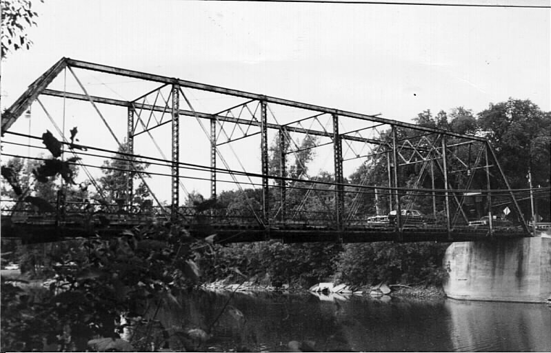
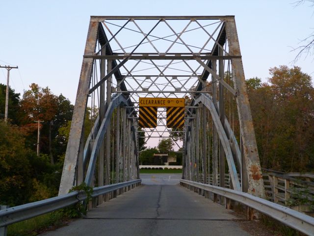
The Currie Parkway Bridge is an eight panel pin-connected truss bridge built by the Joliet Bridge and Iron Company, who built a number of truss bridges in Midland and Saginaw Counties.
This bridge has been recognized as a state historic site, and even has a full-size Michigan historic site interpretive plaque placed, something which only a few of Michigan's historic bridges have. Interpretive plaques are important because they help raise public awareness of the existence and importance of historic bridges.
This bridge was rehabilitated as part of preservation efforts in 1988. This makes it one of the earlier truss preservation projects in Michigan. This fact is apparent in the form of rehabilitation that took place on the bridge, which included adding a structural arch to support traffic loads, rendering the truss decorative (non-structural). Supplemental arches are one way to rehabilitate a historic bridge, although their use is generally considered a compromise preservation solution because while the added arch can increase the load capacity of the bridge and reduce project costs, the arch changes the appearance of the bridge significantly (the arch is hard to ignore when viewing the bridge), and also removes the function of the truss, since the arch is load-bearing. With the Currie Parkway Bridge, one unusual and invasive alteration was that the entire bottom chord connection assemblies were destroyed as part of the rehabilitation, and the bottom chord eyebars were then welded directly to the vertical members about a foot higher. The diagonal members were also crudely welded to the vertical members. This is an unusual alteration that resulted in a significant loss of original bridge material and design, thus having an adverse affect on the historic integrity of the bridge. It is unclear why this was done, as it appears it should have been possible to add the arch without removing the bottom chord connections. If a compromise is being made to add the arch to increase the weight limit (thereby eliminating the need of the truss to bear loads), this should allow for the truss itself to be restored in-kind without alteration, balancing out the negative effect of installing the arch.
Despite severe alterations, the bridge remains an attractive historic bridge that traffic continues to flow over. The bridge actually carries a fairly high volume of traffic for a one-lane bridge, with an Average Daily Traffic of 4,550. Structurally, the bridge is sound, largely because its supporting arch is not old. However, the bridge has an extremely low 1% sufficiency rating, likely a reflection of its traffic volume and one-lane design. The addition of traffic-controlling stoplights at each end of the bridge would be one way to help address this problem. Another solution would be to construct a one-lane bridge parallel to the historic bridge to form a one-way couplet of bridges.
Information and Findings From Michigan Historic Sites OnlineNarrative Description The Upper Bridge is a single-span, 140 foot long, steel Pratt through truss with pinned eye-bar connections, and rests on concrete abutments. The bridge has a twelve-foot wide deck and latticed railings. MARKER TEXT: THE UPPER BRIDGE When completed in 1908 the Upper Bridge, today known as the Currie Parkway Bridge, replaced its wooden predecessor as the main crossing over the Tittabawassee River. The Joliet Bridge and Iron Company of Illinois constructed the bridge for $7,500. It is a 140-foot-long steel Pratt through-truss bridge. In 1955 the Karl B. Robertson Bridge, built one-quarter mile to the south, succeeded the Upper Bridge as the city's main river crossing. In order to preserve the Upper Bridge, the city added an independent structural arch in 1988. Statement of Significance The Upper Bridge is a single-span, 140 foot long, steel Pratt through truss with pinned eye-bar connections, and rests on concrete abutments. The bridge has a twelve-foot wide deck and latticed railings. |
This bridge is tagged with the following special condition(s): Trusses Converted To Decorative
![]()
![]()
![]()
![]()
![]()
Coordinates (Latitude, Longitude):
Search For Additional Bridge Listings:
Bridgehunter.com: View listed bridges within 0.5 miles (0.8 kilometers) of this bridge.
Bridgehunter.com: View listed bridges within 10 miles (16 kilometers) of this bridge.
Additional Maps:
Google Streetview (If Available)
GeoHack (Additional Links and Coordinates)
Apple Maps (Via DuckDuckGo Search)
Apple Maps (Apple devices only)
Android: Open Location In Your Map or GPS App
Flickr Gallery (Find Nearby Photos)
Wikimedia Commons (Find Nearby Photos)
Directions Via Sygic For Android
Directions Via Sygic For iOS and Android Dolphin Browser
USGS National Map (United States Only)
Historical USGS Topo Maps (United States Only)
Historic Aerials (United States Only)
CalTopo Maps (United States Only)

© Copyright 2003-2024, HistoricBridges.org. All Rights Reserved. Disclaimer: HistoricBridges.org is a volunteer group of private citizens. HistoricBridges.org is NOT a government agency, does not represent or work with any governmental agencies, nor is it in any way associated with any government agency or any non-profit organization. While we strive for accuracy in our factual content, HistoricBridges.org offers no guarantee of accuracy. Information is provided "as is" without warranty of any kind, either expressed or implied. Information could include technical inaccuracies or errors of omission. Opinions and commentary are the opinions of the respective HistoricBridges.org member who made them and do not necessarily represent the views of anyone else, including any outside photographers whose images may appear on the page in which the commentary appears. HistoricBridges.org does not bear any responsibility for any consequences resulting from the use of this or any other HistoricBridges.org information. Owners and users of bridges have the responsibility of correctly following all applicable laws, rules, and regulations, regardless of any HistoricBridges.org information.
![]()