


View Information About HSR Ratings
As of June 2024, this historic bridge is slated for a comprehensive restoration for non-motorized traffic. It will become an iconic, signature landmark on the regional trail system!
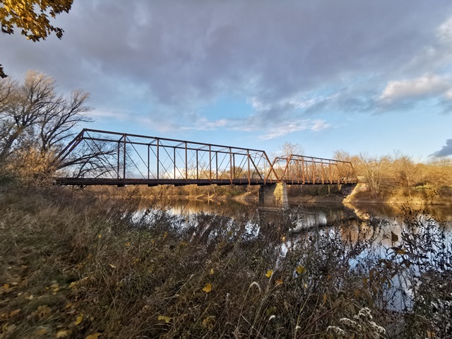
Midland County has this, and the newer Currie Parkway Bridge which are both examples of Joliet Bridge Company work. No plaque survives to list Joliet Bridge Company, but the unusual, yet beautiful, portal bracing decorations are exactly like that on the Dehmel Road Bridge, which archival data has associated the Joliet Bridge Company with. As long as the Joliet Bridge Company is in the area of discussion, it should be noted that the State Street Bridge is also a Joliet bridge. Both the State Street Bridge and this Smiths Crossing Bridge are rare examples of multi-span highway truss bridges in Michigan.
Smiths Crossing Road is known as Bailey Bridge Road north of the bridge. It would appear that Smiths Crossing was later known as Bailey Bridge.
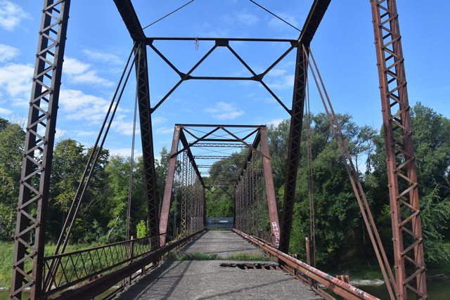
This bridge is a beautiful two-span pin connected Pratt through truss. V-lacing is present on the sway bracing, under the top chord and on vertical members. Each span is nine panels in length. The deck is currently asphalt on corrugated steel, resting on steel stringers. The deck is slowly falling apart. Lattice railings are still on the bridge, although sections are missing or falling off the bridge. Armco guardrails had also been added below the lattice. Both upset and loop-forged eyebars can be found on the bridge. The bridge sits on concrete abutments and piers. Given the lack of multi-span truss bridges in Michigan, the restoration of this bridge will preserve a significant part of Michigan's transportation heritage!
This bridge is tagged with the following special condition(s): Unorganized Photos
![]()
![]()
![]()
![]()
![]()
Coordinates (Latitude, Longitude):
Search For Additional Bridge Listings:
Bridgehunter.com: View listed bridges within 0.5 miles (0.8 kilometers) of this bridge.
Bridgehunter.com: View listed bridges within 10 miles (16 kilometers) of this bridge.
Additional Maps:
Google Streetview (If Available)
GeoHack (Additional Links and Coordinates)
Apple Maps (Via DuckDuckGo Search)
Apple Maps (Apple devices only)
Android: Open Location In Your Map or GPS App
Flickr Gallery (Find Nearby Photos)
Wikimedia Commons (Find Nearby Photos)
Directions Via Sygic For Android
Directions Via Sygic For iOS and Android Dolphin Browser
USGS National Map (United States Only)
Historical USGS Topo Maps (United States Only)
Historic Aerials (United States Only)
CalTopo Maps (United States Only)

© Copyright 2003-2024, HistoricBridges.org. All Rights Reserved. Disclaimer: HistoricBridges.org is a volunteer group of private citizens. HistoricBridges.org is NOT a government agency, does not represent or work with any governmental agencies, nor is it in any way associated with any government agency or any non-profit organization. While we strive for accuracy in our factual content, HistoricBridges.org offers no guarantee of accuracy. Information is provided "as is" without warranty of any kind, either expressed or implied. Information could include technical inaccuracies or errors of omission. Opinions and commentary are the opinions of the respective HistoricBridges.org member who made them and do not necessarily represent the views of anyone else, including any outside photographers whose images may appear on the page in which the commentary appears. HistoricBridges.org does not bear any responsibility for any consequences resulting from the use of this or any other HistoricBridges.org information. Owners and users of bridges have the responsibility of correctly following all applicable laws, rules, and regulations, regardless of any HistoricBridges.org information.
![]()