

View Information About HSR Ratings
This bridge is the last of its kind in Michigan, and although it may not be war surplus, it does utilize a design of bridge created as a part of WWII.
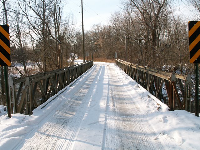
Despite its late 1953 construction date, this is one of the rarest bridges in Michigan: it is the only historic Bailey truss in Michigan. The Bailey truss was developed in 1941 during World War II by the British military as a bridge kit that could be erected with amazing speed and could be easily adjusted to accommodate different span lengths and vehicle loads.
This bridge does not exactly replicate the original Bailey truss design used in World War II. In particular, there is an absence of transom clamps (they look like c-clamps) is perhaps the best example. These clamps attached the truss to the tramsoms. Something that doesn't look like a transom clamp does the job of a transom clamp on this bridge. These differences suggest that this bridge was not a war surplus bridge. It is however an older Bailey truss, as is evidenced by the Carnegie and Illinois mill marks on the steel so the 1953 date seems plausible.
This is a bridge that should appeal to people interested in war history as much as transportation. Although it is doubtful that this bridge was purchased as military surplus or not, it is a good example of the technology that was used by the military to quickly create a bridge. The technology was adaptive; a bridge could vary in size in a number of ways, depending on what the need was. All of this is very clear with the Wilbur Road Bridge. You can see the unused holes and slots on the bridge, and you can see how they fit together like a puzzle. Each truss on the side of the bridge is two trusses wide and one truss high. The technical description of this is "double-truss, single-story." Bailey trusses could vary greatly, this bridge could have been two trusses high for instance, or have only one trusses in width instead of two. The Wilbur Road Bridge sits on concrete abutments and has a wooden deck. The bridge is one lane wide. While on the topic of war history, this bridge crosses the River Raisin, a river that was the site of one of the major battles of the War of 1812.
Although this bridge is a truss bridge by definition, it does not fit well into the realm of most truss bridges. Its late development and use in terms of date, as well as the appearance of the steel, and the overall shape of the bridge are very different from what a truss bridge usually is. Similarly specific terminology was developed by the Army to describe the parts of the bridge and some of these terms conflict with traditional truss terminology. For example, what would be called a floor beam on a traditional truss bridge is called the transom on a Bailey truss.
In 2006, this bridge was replaced. Although HistoricBridges.org has not confirmed this, it was reported that the trusses were successfully marketed for reuse to a private Michigan landowner near the Ohio border who was going to put the bridge on his property. It would be interesting to find out if that really happened.
Information and Findings From Michigan Historic Bridge InventoryNarrative Description Located in a wooded area southwest of Manchester, this bridge carries a one-lane unpaved road over the Raisin River. Concrete footings from a previous span appear on either side of the bridges south abutment. |
![]()
![]()
Coordinates (Latitude, Longitude):
Search For Additional Bridge Listings:
Bridgehunter.com: View listed bridges within 0.5 miles (0.8 kilometers) of this bridge.
Bridgehunter.com: View listed bridges within 10 miles (16 kilometers) of this bridge.
Additional Maps:
Google Streetview (If Available)
GeoHack (Additional Links and Coordinates)
Apple Maps (Via DuckDuckGo Search)
Apple Maps (Apple devices only)
Android: Open Location In Your Map or GPS App
Flickr Gallery (Find Nearby Photos)
Wikimedia Commons (Find Nearby Photos)
Directions Via Sygic For Android
Directions Via Sygic For iOS and Android Dolphin Browser
USGS National Map (United States Only)
Historical USGS Topo Maps (United States Only)
Historic Aerials (United States Only)
CalTopo Maps (United States Only)

© Copyright 2003-2025, HistoricBridges.org. All Rights Reserved. Disclaimer: HistoricBridges.org is a volunteer group of private citizens. HistoricBridges.org is NOT a government agency, does not represent or work with any governmental agencies, nor is it in any way associated with any government agency or any non-profit organization. While we strive for accuracy in our factual content, HistoricBridges.org offers no guarantee of accuracy. Information is provided "as is" without warranty of any kind, either expressed or implied. Information could include technical inaccuracies or errors of omission. Opinions and commentary are the opinions of the respective HistoricBridges.org member who made them and do not necessarily represent the views of anyone else, including any outside photographers whose images may appear on the page in which the commentary appears. HistoricBridges.org does not bear any responsibility for any consequences resulting from the use of this or any other HistoricBridges.org information. Owners and users of bridges have the responsibility of correctly following all applicable laws, rules, and regulations, regardless of any HistoricBridges.org information.
![]()