Official Heritage Listing Information and Findings
England: Listed At: Grade I
Scotland: Listed At: Category A
Scotland (Bridge House): Listed At: Category C
Discussion: England:
List Entry Number: 1042214
Summary
Suspension bridge. 1819-20 by Captain Samuel Brown, Royal Navy, with
advice from John Rennie. Improved and strengthened by J A Bean for Tweed
Bridge Trustees, 1902-3. Sandstone ashlar piers. Iron with wood roadway.
Reasons for Designation
The Union Suspension Bridge of 1819-20 by
Captain Samuel Brown is listed at Grade I for the following principal
reasons: * Date: as a an early C19 suspension bridge, the structure sits
in the period when there is a presumption in favour of listing;
*Technological Innovation: the bridge was the first road suspension
bridge in Britain and, when built, the longest span in the world. The
new suspension bridge technology pioneered here allowed bridges to span
large widths at a fraction of the cost of more traditional construction
techniques.
History
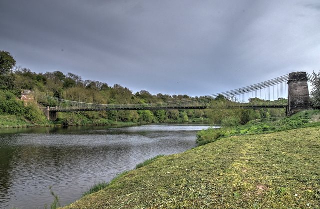
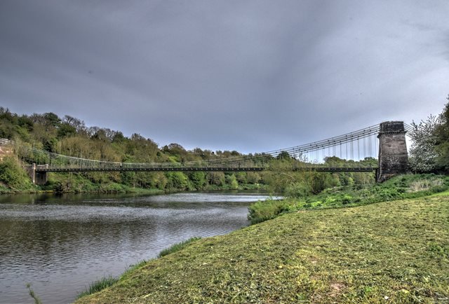
The Union Suspension Bridge was erected on
behalf of the Berwick and North Durham Turnpike Trust and opened on 26
July 1820. Spanning the River Tweed (the county and national boundary
between Scotland and England), it was the first road suspension bridge
in Britain and is the oldest still in use as such. For six years it had
the longest span in the world, equal to a rope bridge in Tibet, until
surpassed by the Menai Bridge. Technological innovation enabled
suspension bridges to span large widths at a fraction of the cost of
their masonry equivalents; the Union Bridge being 368ft long, 18ft wide,
27ft above the water and having cost approximately 7500 pounds to erect,
rather than the anticipated £20,000 for a stone bridge. Captain Samuel
Brown's bar links (patented by him in 1817) were used here for the first
time. In 1902-3 the upper wire cables were added in case of a failure in
the main chains and further suspenders added to the steel reinforcement
at the sides of the timber deck. The deck was renewed in 1871 and again
in 1974.
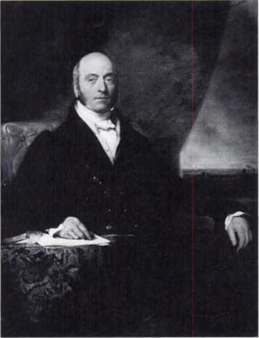
Captain Samuel Brown (1776-1851) joined the Royal Navy
in 1795. Following the Napoleonic Wars, he formed a partnership with his
cousin Samuel Lennox to manufacture anchor cable made from chain for use
on naval vessels. Previously cables were made from hemp. His successful
designs and the patents he took out on them meant he was soon the
Admiralty's sole supplier of chain anchor cables. Beside his work for
vessels, Brown also supplied the chainwork for approximately forty piers
and suspension bridges. Brighton Chain Pier (1823) is a well-known
example of the former and the Union Suspension Bridge being amongst the
best examples of the latter.
The ‘Union Suspension Bridge (That
Part In Scotland)' is also listed as a category A building in the
Scottish Borders. It was formerly a scheduled monument and was
de-scheduled 20 December 1999.
Details
Suspension bridge.
1819-20 by Captain Samuel Brown, Royal Navy, with advice from John
Rennie. Improved and strengthened by J A Bean for Tweed Bridge Trustees,
1902-3. Sandstone ashlar piers. Iron with wood roadway.
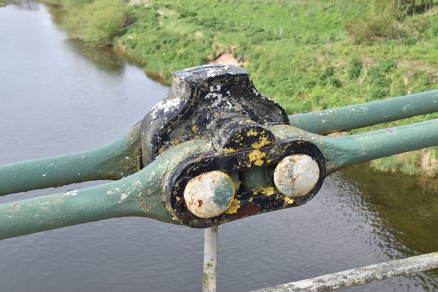
DESCRIPTION: Timber carriageway spanning the River Tweed suspended from
3 pairs of swept, wrought iron chains of elongated eye bar links. The
upper steel cable is a later strengthening.
On the west
(Scottish) side, tall battered, rusticated pier of pink sandstone with
keystoned round arch for the roadway, bold dentilled cornice and high
blocking course carrying the cables. In the blocking course an iron
inscription VIS UNITA FORTIOR 1820, (‘United Strength is Stronger’) with
intertwined roses and thistles. The pier at the English end is built
into the cliff. Also of pink sandstone, it has similar rustication and 2
stages. The lower stage contains an pilastered doorway with modillion
cornice surrounding a bronze memorial plaque of 1902; this stage has a
modillion cornice. Battered upper stage has dentilled cornice and a high
blocking course bearing a similar iron inscription and intertwined roses
and thistles as the pier on the west side.
Rectangular-plan,
pink sandstone piers flanking carriageway to W with rubble-coped rubble
walls linking pylon to E. Pyramidal-capped, square-plan, pink sandstone
piers flanking carriageway to W of E pylon; rubble-coped rubble walls to
E.
Discussion: Scotland:
Historic Environment Scotland Number: LB13645
Description
Captain Samuel Brown, Royal Navy, with advice from John
Rennie, 1819-20; improved and strengthened by J A Bean for Tweed Bridge
Trustees, 1902-3. Timber carriageway spanning River Tweed suspended from
3 pairs of swept, wrought iron chains of elongated eye bar links.
Wrought iron bolt brackets link iron rod suspenders; upper wire cables.
Iron railings threaded around suspenders enclosing sides. Channelled
pink sandstone, tapering rectangular-plan pylon to W (Scottish) side
with keystoned, round-arched opening at centre; mutuled cornice; tall
parapet with carved roses and thistles surmounting central block
inscribed 'VIS UNITA FORTIOR 1820' to E. Channelled pink sandstone,
tapering pylon set into rock face to E (English) side with blocked,
pilastered doorway centred at ground framing memorial plaque; mutuled
cornice; tall parapet with carved roses and thistles surmounting central
block also inscribed 'VIS UNITA FORTIOR 1820'. Rectangular-plan, pink
sandstone piers flanking carriageway to W with rubble-coped rubble walls
linking pylon to E. Pyramidal-capped, square-plan, pink sandstone piers
flanking carriageway to W of E pylon; rubble-coped rubble walls to E.
Statement of Special Interest
The Union Suspension Bridge,
erected on behalf of the Berwick and North Durham Turnpike Trust and
opened 26 July 1820, is the first road suspension bridge in Britain and
the oldest still in use as such (2014). For six years it had the longest
span in the world, equal to a rope bridge in Tibet, until surpassed by
the Menai Bridge.
Spanning the River Tweed (the county and
national boundary between Scotland and England), this elegant chain
bridge with sweeping chains and monumental pylons remains much as it was
when first complete. Technological innovation enabled suspension bridges
to span large widths at a fraction of the cost of their masonry
equivalents - the Union Bridge being 368ft long, 18ft wide, 27ft above
the water and having cost approximately 7500 pounds to erect. Brown's
bolt brackets (patented by him in 1817) are used here for the first
time. In 1902-3 the upper wire cables were added in case of a failure in
the main chains and further suspenders added to the steel reinforcement
at the sides of the timber deck. The deck was renewed in 1871 and again
in 1974.
Captain Samuel Brown (1776-1851) joined the Royal Navy
in 1795. Following the Napoleonic Wars, he formed a partnership with his
cousin Samuel Lennox to manufacture anchor cable made from chain for use
on naval vessels. Previously cables were made from hemp. His successful
designs and the patents he took out on them meant he was soon the
Admiralty's sole supplier of chain anchor cables. Beside his work for
vessels, Brown also supplied the chainwork for approximately forty piers
and suspension bridges. Brighton Chain Pier (1823) is a well-known
example of the former and the Union Suspension Bridge being amongst the
best examples of the latter. Suspension bridges using chain were known
simply as chain bridges until wire cable suspension came in to use circa
1870; from this date this type of bridge is usually referred to as
'cable suspension bridge'.
The Union Suspension Bridge tollhouse
is situated to the west of the bridge (see separate listing). 'Vis Unita
Fortior' translates as 'United Strength is Stronger'.
'Union
Suspension Bridge (That Part In England)' is also listed, Grade I in
Horncliffe Parish, Northumberland.
Formerly a scheduled monument.
De-scheduled 20 December 1999.
Discussion: Scotland (Bridge House):
Historic Environment Scotland Number: LB47714
Description
Circa 1820 with later additions and alterations. Single
storey with attic, 3-bay, originally L-plan former tollhouse with single
storey and basement wing to SE; single storey garage block to NW. Harl-pointed
sandstone rubble; tooled sandstone dressings. Base course; eaves course.
Rusticated quoins; droved long and short surrounds to openings;
projecting cills.
NE (ENTRANCE) ELEVATION: modern, part-glazed
timber panelled door centred at ground; modern, glazed fanlight; single
windows flanking. Later wing recessed to outer left. Garage block
recessed to outer right.
SE (SIDE) ELEVATION: central opening;
single window to outer right; single opening to left; projecting wing
adjoined to outer left; piended dormer recessed above.
NW (SIDE)
ELEVATION: single window to outer left; opening to outer right.
12-pane glazing in timber sash and case windows; modern windows to
dormer and SE wing; rooflights. Grey slate piend and platform roof.
Coped, brick-built ridge stack; circular cans.
INTERIOR: not seen
1999.
Statement of Special Interest
Originally associated and
presumably contemporary with the nearby Union Suspension Bridge - see
separate list entry. Now in separate ownership (1999). A
modestly-detailed, early 19th century cottage, the core of which remains
intact. Marked on the 1857 OS map as 'Union Bridge Toll'.
|