We Recommend:
Bach Steel - Experts at historic truss bridge restoration.
Waterloo Bridge

Primary Photographer(s): Nathan Holth
Bridge Documented: May 20, 2017 and 2021
Rural: Culpeper County, Virginia and Fauquier County, Virginia: United States
Metal 8 Panel Pin-Connected Pratt Through Truss, Fixed and Approach Spans: Metal Stringer (Multi-Beam), Fixed
1879 By Builder/Contractor: Pittsburgh Bridge Company of Pittsburgh, Pennsylvania
2020
100.0 Feet (30.5 Meters)
366.0 Feet (111.6 Meters)
11.2 Feet (3.41 Meters)
1 Main Span(s) and 15 Approach Span(s)
5622

View Information About HSR Ratings
Bridge Documentation
This bridge has long suffered from a poorly documented history, something that even extended into Historic American Engineering Record documents for the bridge. The information presented on HistoricBridges.org represents the latest findings of research conducted by members of the community in which the bridge is located. Specifically, the following confirms the date and builder of the bridge:
The Fauquier County Court Minute Book 1876-1880 stated the following about the bridge on Page 243: July 25, 1878 - "This day the Fauquier Comms. filed the report accepting the Bridge over the Rappk. River at Waterloo, erected by the Pittsburg Bridge Company, & s[ ] is confirmed. And the Court doth order the County Treasurer of Fauquier County to pay to T.N. Fletcher one of the Comms. on the part of Fauquier County the sum of $620.00 the balance due said Pittsburg Bridge Company in full of said Bridge..."
The bridge was configured in 1919 by the replacement of the superstructures of the approach spans and installation of pipe railing on the whole bridge. This work was completed by the by Virginia Bridge and Iron Company of Roanoke, Virginia.
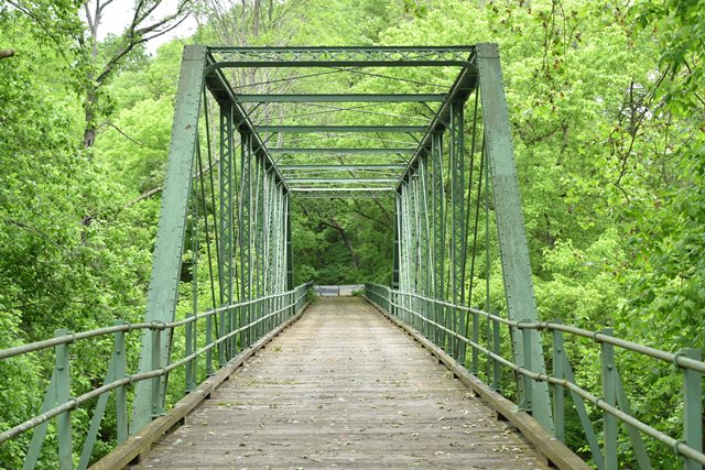
This bridge is largely unaltered beyond the 1919 changes making it both an outstanding example of an early Pittsburgh Bridge Company bridge as well as an early example of a traditional pin-connected Pratt truss. Its vertical members are composed of angles rather than channel making it look lighter weight than most bridges of this type.
The future of this bridge has been uncertain for many years, but the bridge enjoys strong community support. Support from Virginia Department of Transportation in contrast was less consistent. As of 2018 after a long fight, a decision was made to rehabilitate the bridge for vehicular traffic. This represents a victory overall as previous proposals were for the bridge to be demolished or to try to find some third party to preserve the bridge. However the project did replace a large amount of original bridge material. The need for this replacement does not make sense in light of the bridge's good overall condition due to the rust resistant properties of the wrought iron from which it is built, as well as when comparing rehabilitations of similar bridges in other states where more original material was retained. However, Virginia has one of the most conservative engineering stances in the country (for unknown reasons) with one VDOT engineer going so far as to condemn literally hundreds if not thousands of projects across the country to rehabilitate bridges composed of paired eyebars (which includes most pin-connected highway truss bridges) as (and this is a quote) "Russian Roulette." Such a statement is unsubstantiated given the countless engineers who have placed their stamps (and thus their professional livelihood) on these rehabilitation projects, as well as the fact that truss bridge failures are almost always the result of design errors that existed from Day 1 and are unique to specific bridges, or are the result of accidents or user stupidity, such as a large 40 ton 14 foot tall truck trying to cross a bridge with an 11 foot overhead clearance and a 3 ton weight limit.
Given this somewhat inhospitable environment for bridge preservation in Virginia, the rehabilitation of the Waterloo Bridge represents a huge success story, even given the replacement of original material on the bridge. View YouTube video showing the truss being picked for rehabilitation.
View Archived National Bridge Inventory Report - Has Additional Details and Evaluation
View Historic American Engineering Record (HAER) Documentation For This Bridge
HAER Data Pages, PDF

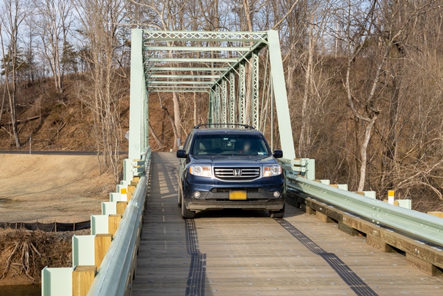
Above: Bridge after rehabilitation. Photo Credit: Hugh Kenny, Piedmont Environmental Council
This bridge is tagged with the following special condition(s): Unorganized Photos
![]()
Photo Galleries and Videos: Waterloo Bridge
Bridge Photo-Documentation
Original / Full Size PhotosA collection of overview and detail photos. This gallery offers photos in the highest available resolution and file size in a touch-friendly popup viewer.
Alternatively, Browse Without Using Viewer
![]()
Bridge Photo-Documentation
Mobile Optimized PhotosA collection of overview and detail photos. This gallery features data-friendly, fast-loading photos in a touch-friendly popup viewer.
Alternatively, Browse Without Using Viewer
![]()
Post-Rehab Additional Unorganized Photos
Original / Full Size PhotosA supplemental collection of photos that are from additional visit(s) to the bridge and have not been organized or captioned. This gallery offers photos in the highest available resolution and file size in a touch-friendly popup viewer.
Alternatively, Browse Without Using Viewer
![]()
Post-Rehab Additional Unorganized Photos
Mobile Optimized PhotosA supplemental collection of photos that are from additional visit(s) to the bridge and have not been organized or captioned. This gallery features data-friendly, fast-loading photos in a touch-friendly popup viewer.
Alternatively, Browse Without Using Viewer
![]()
Maps and Links: Waterloo Bridge
Coordinates (Latitude, Longitude):
Search For Additional Bridge Listings:
Bridgehunter.com: View listed bridges within 0.5 miles (0.8 kilometers) of this bridge.
Bridgehunter.com: View listed bridges within 10 miles (16 kilometers) of this bridge.
Additional Maps:
Google Streetview (If Available)
GeoHack (Additional Links and Coordinates)
Apple Maps (Via DuckDuckGo Search)
Apple Maps (Apple devices only)
Android: Open Location In Your Map or GPS App
Flickr Gallery (Find Nearby Photos)
Wikimedia Commons (Find Nearby Photos)
Directions Via Sygic For Android
Directions Via Sygic For iOS and Android Dolphin Browser
USGS National Map (United States Only)
Historical USGS Topo Maps (United States Only)
Historic Aerials (United States Only)
CalTopo Maps (United States Only)


