We Recommend:
Bach Steel - Experts at historic truss bridge restoration.
Miscauno Island Bridge East

Primary Photographer(s): Nathan Holth
Bridge Documented: October 1, 2012
Shoreline Drive (Miscauno Island Lane) Over Menominee River Channel
Rural: Marinette County, Wisconsin, and Menominee County, Michigan: United States
Not Available or Not Applicable
Not Available
92.0 Feet (28 Meters)
Not Available
1 Main Span(s)
Not Applicable

View Information About HSR Ratings
Bridge Documentation
Visit The Four Seasons Island Resort Website
View A Historical Article About The Island Resort
Miscauno Island: Its Bridges and Resort
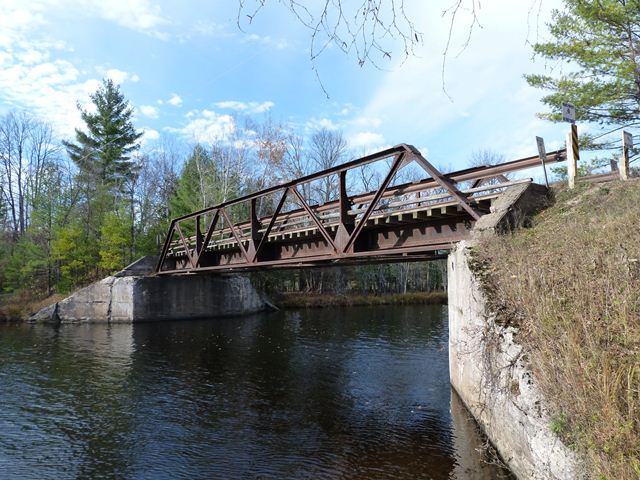
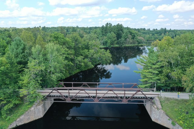
Miscauno Island is a tiny island in the middle of the Menominee River, which in this area forms the state line between Michigan and Wisconsin. The island itself is within Wisconsin. There is also a tiny unnamed island immediately east of Miscauno Island. As such, the Menominee River splits into three channels in this area. In ca. 1904, the Wisconsin and Michigan Railroad decided to extend its railroad line over the Menominee River at this point, to connect their railroad to a logging company the railroad had purchased. Crossing the river at this point required three bridges to span the three channels of the river. These are the bridges seen today, presumed to have been built ca. 1904, coinciding with the railroad line's expansion. The western bridge is a through truss bridge. The middle bridge is also a through truss. The eastern bridge is a pony truss. The railroad company also had another idea, which was to construct a secluded resort on Miscauno Island, which would attract wealthy Chicagoans, by providing them an easy way to escape the city to a quiet rural location. The resort opened in 1905. The railroad company could then profit not only from the operation of the resort, but as the sole means of transportation to the island, could also profit from providing visitors with transportation. In an era before freeways and with motor vehicles just beginning to become common, it is not difficult to see how this could be profitable for the railroad. In 1923, the resort burned to the ground, but was rebuilt in 1925. Eventually, the railroad line was abandoned by trains. The bridges were converted for vehicular use to allow motor vehicles to visit the resort. The resort that stands today is the 1925 building, which has been restored in recent years. Originally called the Miscauno Inn, the resort is today called the Four Seasons Island Resort. The 1904 bridges, privately owned by by the resort, continue to be the only means of access to the island and resort and are in use by motor vehicles. Their heavy trusses, massive floorbeams and deck stringers, and narrow one-lane width all are reminders of this resort's railroad roots. The bridges also serve as visual gateways onto and off of the island. As railroad bridges, these truss bridges are far heavier in construction than highway bridges from 1904 would have been. The steel trusses remain in good condition today and are more than sufficient to handle the weight of resort visitors.
The Four Seasons Island Resort continues to operate today. It is a rare opportunity to experience the beauty of a restored historic resort building dating to 1925, and to experience what a vacation for wealthy Chicagoans in the early 20th Century would have been like. As mentioned, the bridges are owned by the resort, and are not owned by any public agency. The resort website has several photos that feature the bridges on it, suggesting that the resort recognizes the heritage and beauty these bridges contribute to the resort experience. By visiting the resort, which receives positive online reviews, you can support owners who have chosen to continue to preserve and use these historic bridges as functional crossings.
About This Bridge
The eastern bridge is the "black sheep" of the trio of bridges. As a shorter crossing, a pony truss was built here instead of a through truss. Pony truss railroad bridges are uncommon, since plate girders were more common for short spans such as this. This pony truss uses riveted connections, instead of the pinned connections on the through truss bridges. 1904 was a period where bridge builders were moving away from pin-connected truss bridges to more rigid rivet-connected truss bridges. The development of tools that eased the process of riveting in the field caused this transition. Pin-connected truss bridges did not require field riveting. Pony truss bridges like this bridge tended to be built with riveted connections before larger through truss bridges, presumably because larger portions of the smaller bridges could be riveted in the shop (which meant that very little field riveting was actually needed to build the rivet-connected pony truss). This may explain why the Miscauno Island through trusses are pin-connected instead. This pony truss has some unusual details. Extra plate is riveted to the bridge at the connection points to strengthen the top chord where it is needed the most. Some of the other built-up members of the truss are composed in uncommon ways. The unusual composition is hard to describe concisely, but the way in which rolled pieces were riveted together and the types of rolled pieces chosen simply are different from what other highway and railroad bridges tend to display. This is particularly unusual because the Miscauno Island through trusses are, in contrast, traditionally composed and do not display unusual details in the composition of their built-up beams.
The bridge's trusses today remain in good physical condition. While the bridge does not currently have a coat of paint on it, the very heavy railroad-style trusses only have surface rust on them and no deteriorating section loss. Paint is not as important on these massive railroad members provided winter deicing salts are kept away from the bridge. Removing any moisture-trapping dirt that builds up on the bridge, particularly on the bottom chord and bearings, will also help keep the trusses in good condition, even without paint. The bridge's concrete abutments do show signs of spalling and efflorescence. In the long term, repair work on the abutments will likely need to be considered.
Above: Aerial view of bridge, August 27, 2020. Click for enlargement. Photo Credit: Doug Heim, Angelcopter, LLC
![]()
Photo Galleries and Videos: Miscauno Island Bridge East
Bridge Photo-Documentation
Original / Full Size PhotosA collection of overview and detail photos. This gallery offers photos in the highest available resolution and file size in a touch-friendly popup viewer.
Alternatively, Browse Without Using Viewer
![]()
Bridge Photo-Documentation
Mobile Optimized PhotosA collection of overview and detail photos. This gallery features data-friendly, fast-loading photos in a touch-friendly popup viewer.
Alternatively, Browse Without Using Viewer
![]()
Eastbound Crossing
Full Motion VideoStreaming video of the bridge. Also includes a higher quality downloadable video for greater clarity or offline viewing.
![]()
Drone Footage, Courtesy Doug Heim, Angelcopter, LLC
Full Motion VideoNote: The downloadable high quality version of this video (available on the video page) is well worth the download since it offers excellent 1080 HD detail and is vastly more impressive than the compressed streaming video. Streaming video of the bridge. Also includes a higher quality downloadable video for greater clarity or offline viewing.
![]()
Maps and Links: Miscauno Island Bridge East
This bridge is private property, but is open to anyone visiting the Four Seasons Island Resort.
Coordinates (Latitude, Longitude):
Search For Additional Bridge Listings:
Bridgehunter.com: View listed bridges within 0.5 miles (0.8 kilometers) of this bridge.
Bridgehunter.com: View listed bridges within 10 miles (16 kilometers) of this bridge.
Additional Maps:
Google Streetview (If Available)
GeoHack (Additional Links and Coordinates)
Apple Maps (Via DuckDuckGo Search)
Apple Maps (Apple devices only)
Android: Open Location In Your Map or GPS App
Flickr Gallery (Find Nearby Photos)
Wikimedia Commons (Find Nearby Photos)
Directions Via Sygic For Android
Directions Via Sygic For iOS and Android Dolphin Browser
USGS National Map (United States Only)
Historical USGS Topo Maps (United States Only)
Historic Aerials (United States Only)
CalTopo Maps (United States Only)


