We Recommend:
Bach Steel - Experts at historic truss bridge restoration.
St. Charles Air Line Bridge
18th Street Railroad Bridge

Primary Photographer(s): Nathan Holth
Bridge Documented: August 12, 2006 - June 13, 2021
Chicago: Cook County, Illinois: United States
Metal Rivet-Connected Warren Through Truss, Movable: Single Leaf Bascule (Heel Trunnion)
1919 By Builder/Contractor: American Bridge Company of New York, New York and Engineer/Design: Strauss Bascule Bridge Company (Strauss Engineering Company) of Chicago, Illinois
1930
220.0 Feet (67.1 Meters)
220.0 Feet (67.1 Meters)
Not Available
1 Main Span(s)
Not Applicable

View Information About HSR Ratings
Bridge Documentation
View Historic American Engineering Record (HAER) Documentation For This Bridge
HAER Data Pages, HTML - HAER Data Pages, PDF
View Historical Articles Discussing St. Charles Air Line Bridge in PDF Format
View 1898 Article Discussing The Elevation of the Air Line in PDF Format
View Strauss Patent 738954 and Strauss Patent 995813
View Counterweight Rehab Article
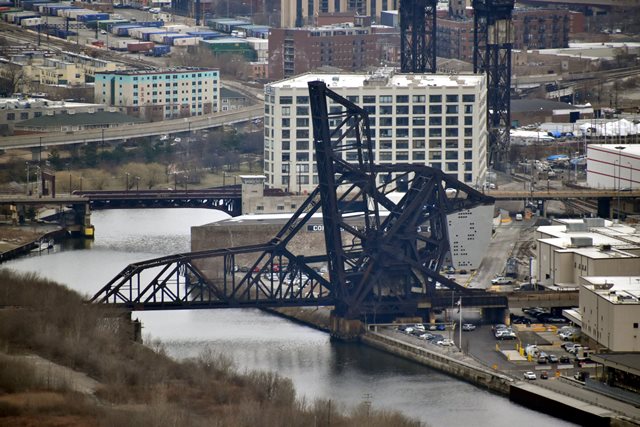
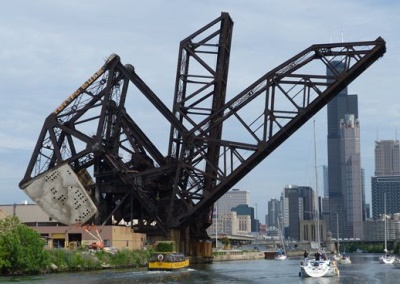
Note: This page covers the St. Charles Air Line Bridge. This is the bridge remains open to railroad traffic and is shown in the lowered position in the above photo. Its companion, the Baltimore and Ohio Railroad / Chicago Terminal Bridge has its own page here. Additionally, a discussion not only of the St. Charles Air Line Bridge, but of the Chicago Terminal Bridge as they relate to each other in context can be found on the page you are viewing now.
About the St. Charles Air Line Bridge
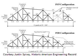
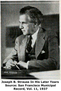
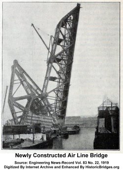
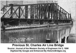
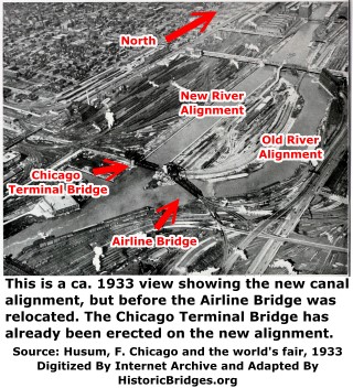
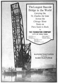
This is the bridge that is in the lower position in the photos, the southernmost bridge. According to Historic American Engineering Record, the St. Charles Air Line Bridge, today a CN line, was originally 40 feet longer than it is today. Originally, its leaf was a record-setting (at the time) length of 260 feet. When built in 1919 though it was designed to be relocated and shortened in anticipation of a future project to move and straighten the river. When this project was completed in 1930, this then allowed for the bridge to be moved and shortened to its current 220 foot leaf length. The bridge is a Strauss trunnion, having been designed by the Strauss Bascule Bridge Company. Joseph Strauss was known for his many patents on movable bridges and other structures dealing with motion. The St. Charles Air Line Bridge was fabricated by the American Bridge Company. The bridge, in its original location, was erected by the Ferro Construction Company of Chicago. The bridge, in its original location, sat on a substructure built by The Foundation Company of New York, New York. E. J. Albrecht Company of Chicago erected the substructure for the bridge in its new location and the Strobel Steel Construction Company of Chicago dismantled and re-erected the superstructure in its new location.
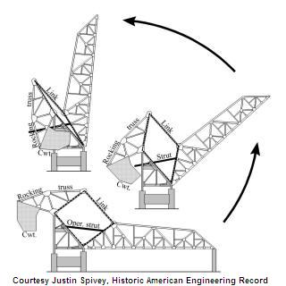
As a heel-trunnion bascule bridge, the operation of this bridge includes a counterweight that is not fixed and moves independently of the motion of the moving bridge as seen in the diagram to the right. This bridge still operates for boats, particularly during the spring and fall seasons to allow access to a boat storage facility.
A July 29, 1920 article in the Engineering News-Record commented that on June 23, 1920 the bridge made an appearance in a movie.
Ferro Construction Company of Chicago, which constructed the substructure for the original bridge's location, was formed in 1907 by B. B. Sierts and F. C. Fisher. The December 21, 1916 issue of Engineering News (Vol 76., No.25) provided the following information about F. C. Fisher.
F. C. Fisher, President of the Ferro Construction Co., Chicago, whose death on Dec. 6 was noted in these columns last week, was born at Lake Linden, Mich., May 24, 1871. He graduated from the grammar and high school at Lake Linden, and also graduated from the Engineering Department of the University of Michigan at Ann Arbor. After leaving the University he was employed by the Detroit Bridge Co., and also the American Bridge Works, of Chicago, as draftsman and engineer. In 1899 he had charge of the erection of the steelwork for the Great Northern Ry. grain elevator at West Superior, Wis. He also had charge of the erection of the railway cantilever bridge over the Mississippi River at Thebes, 111., and the bridge of the Fort Dodge, Des Moines & Southern Ry. at Fort Dodge, Iowa. In March. 1907, he and B. B. Sierts formed the Ferro Construction Co., of Chicago, and he was its President until his death. His company has done erection work for several of the large railways, and its business will be continued. His most recent work was the erection of the 600-ft. steel-arch span for the new Detroit-Superior viaduct at Cleveland, Ohio, and he also erected the mile of steel towers and girders for the new Clark Ave. viaduct, at Cleveland. Mr. Fisher leaves a widow and two children.
This bridge can be viewed from the 18th Street Bridge. Additionally, now that Ping Tom Park extends north of the 18th Street Bridge, Ping Tom Park is now a source of outstanding views of this bridge.
It should be noted that according to the Historic American Engineering Record, original plans for this bridge do survive. However, the current owner of the plans, Canadian National, has refused to allow anyone to even look at them.
The Threat of Demolition and Why These Bridges Should Instead Be Preserved
Not everyone's opinion of "beautiful" is the same, and while some may feel that these two bridges are gorgeous geometric works of art, with their pleasingly complex arrangement of trusses that allows the mind to wander in a tangle of trusses trying to figure out how it all "works" physically, others feel that these bridges look like unused remnants of a long-gone industrial era and feel that they are no more attractive than an abandoned, crumbling warehouse. As such, there has been talk of demolishing them as residential developments are being built in the area. Some people say these bridges do not have a place in a financial-centered city filled with modern skyscrapers. However these comments fail to regard the contrast between modern and historic that defines Chicago. There are countless places across the city where modern skyscrapers sit next to a historic skyscrapers. It is this contrast that makes Chicago special, where heritage and modern construction can live side by side. It makes the city more interesting. Further, it is like seeing a timeline for Chicago. Consider the photo on this page. Here we see a progression, from the industrial past (the bridge, and paper mill) in the foreground, to the financial businesses and other skyscrapers today rising up in the background. It is a beautiful contrast. And if not for possible aesthetic value, these bridges should be saved because of their historic value. The prosperous Chicago of today has this industrial past to thank. Chicago's success as an industrial and railroad center were what allowed it to develop into the great city it is today. Chicago owes these bridges respect, and should preserve them as a memorial to their less-glamorous, but equally important, past. Also, one thing that could be done to make these bridges fit in a bit better is to paint them a color that is more attractive than black. Paint them white or sky blue, or even the maroon that so many bridges have been painted and they will have a more "modern" look to them. The Cherry Avenue Bridge near North Avenue is an example of how an old railroad bridge can be made new and spectacular again.
On the brighter side, the bridge has been protected by designation as a Chicago Landmark. Demolition of the bridge would require the approval of council. While this may not prevent demolition, it does provide a barrier to demolition and also makes the statement that in the eyes of the city, this bridge is an important, worthwhile part of the city.
|
Main Plaque STRAUSS TRUNNION BASCULE BRIDGEPATENTED BUILT 1917 FOR ST. CHARLES AIR LINE FABRICATED BY AMRICAN BRIDGE CO. |
Erector Plaque ERECTED BYTHE FERRO CONSTRUCTION CO. CHICAGO |
Above: The Foundation Company was responsible for constructing the substructure for this bridge in its former/original location. Fred W. Adgate was a consulting engineer and Chicago manager for the New York City based company. He was assistant Chicago manager until 1909 when his father George Adgate, who was Chicago manager at that time died, at which point he appears to have become Chicago manager. Click his photo above to view an enlarged image that includes a brief biography.


Information and Findings From Chicago Landmarks DesignationGeneral Information Address: North of 16th St., East of Lumber St. This Bridge Is A Designated Chicago Landmark |
![]()
Historic Bridges of Chicago and Cook County


Chicago and Cook County are home to one of the largest collections of historic bridges in the country, and no other city in the world has more movable bridges. HistoricBridges.org is proud to offer the most extensive coverage of historic Chicago bridges on the Internet.
General Chicago / Cook County Bridge Resources
Chicago's Bridges - By Nathan Holth, author of HistoricBridges.org, this book provides a discussion of the history of Chicago's movable bridges, and includes a virtual tour discussing all movable bridges remaining in Chicago today. Despite this broad coverage, the book is presented in a compact format that is easy to take with you and carry around for reference on a visit to Chicago. The book includes dozens of full color photos. Only $9.95 U.S! ($11.95 Canadian). Order Now Direct From The Publisher! or order on Amazon.
Chicago River Bridges - By Patrick T. McBriarty, this is a great companion to Holth's book shown above. This much larger book offers an extremely in-depth exploration of Chicago's movable highway bridges, including many crossings that have not existed for many years. Order Now Direct From The Publisher! or order on Amazon.
View Historic American Engineering Record (HAER) Overview of Chicago Bascule Bridges (HAER Data Pages, PDF)
Chicago Loop Bridges - Chicago Loop Bridges is another website on the Internet that is a great companion to the HistoricBridges.org coverage of the 18 movable bridges within the Chicago Loop. This website includes additional information such as connections to popular culture, overview discussions and essays about Chicago's movable bridges, additional videos, and current news and events relating to the bridges.
Additional Online Articles and Resources - This page is a large gathering of interesting articles and resources that HistoricBridges.org has uncovered during research, but which were not specific to a particular bridge listing.
This bridge is tagged with the following special condition(s): Unorganized Photos
![]()
Photo Galleries and Videos: St. Charles Air Line Bridge
Bridge Photo-Documentation
Original / Full Size PhotosA collection of overview and detail photos. This gallery offers photos in the highest available resolution and file size in a touch-friendly popup viewer.
Alternatively, Browse Without Using Viewer
![]()
Bridge Photo-Documentation
Mobile Optimized PhotosA collection of overview and detail photos. This gallery features data-friendly, fast-loading photos in a touch-friendly popup viewer.
Alternatively, Browse Without Using Viewer
![]()
Additional Unorganized Photos
Original / Full Size PhotosA supplemental collection of photos that are from additional visit(s) to the bridge and have not been organized or captioned. This gallery offers photos in the highest available resolution and file size in a touch-friendly popup viewer.
Alternatively, Browse Without Using Viewer
![]()
Additional Unorganized Photos
Mobile Optimized PhotosA supplemental collection of photos that are from additional visit(s) to the bridge and have not been organized or captioned. This gallery features data-friendly, fast-loading photos in a touch-friendly popup viewer.
Alternatively, Browse Without Using Viewer
![]()
Bridge Being Raised
Full Motion VideoNote: The downloadable high quality version of this video (available on the video page) is well worth the download since it offers excellent 1080 HD detail and is vastly more impressive than the compressed streaming video. Streaming video of the bridge. Also includes a higher quality downloadable video for greater clarity or offline viewing.
![]()
Bridge Being Lowered
Full Motion VideoNote: The downloadable high quality version of this video (available on the video page) is well worth the download since it offers excellent 1080 HD detail and is vastly more impressive than the compressed streaming video. Streaming video of the bridge. Also includes a higher quality downloadable video for greater clarity or offline viewing.
![]()
Distant View, Bridge Being Raised
Full Motion VideoAerial Video Courtesy Cody J. Morris. Streaming video of the bridge. Also includes a higher quality downloadable video for greater clarity or offline viewing.
![]()
Maps and Links: St. Charles Air Line Bridge
Coordinates (Latitude, Longitude):
Search For Additional Bridge Listings:
Bridgehunter.com: View listed bridges within 0.5 miles (0.8 kilometers) of this bridge.
Bridgehunter.com: View listed bridges within 10 miles (16 kilometers) of this bridge.
Additional Maps:
Google Streetview (If Available)
GeoHack (Additional Links and Coordinates)
Apple Maps (Via DuckDuckGo Search)
Apple Maps (Apple devices only)
Android: Open Location In Your Map or GPS App
Flickr Gallery (Find Nearby Photos)
Wikimedia Commons (Find Nearby Photos)
Directions Via Sygic For Android
Directions Via Sygic For iOS and Android Dolphin Browser
USGS National Map (United States Only)
Historical USGS Topo Maps (United States Only)
Historic Aerials (United States Only)
CalTopo Maps (United States Only)

