We Recommend:
Bach Steel - Experts at historic truss bridge restoration.
Fullerton Avenue Bridge

Primary Photographer(s): Nathan Holth
Bridge Documented: December 15, 2010
Detroit: Wayne County, Michigan: United States
1963 By Builder/Contractor: Walter Toebe Company and Engineer/Design: Michigan State Highway Department
Not Available or Not Applicable
53.8 Feet (16.4 Meters)
167.0 Feet (50.9 Meters)
44 Feet (13.41 Meters)
2 Main Span(s)
82182192000S160

View Information About HSR Ratings
Bridge Documentation
This bridge has been altered, resulting in a severe loss of historic integrity and significance!
View Archived National Bridge Inventory Report - Has Additional Details and Evaluation
This bridge had the railings which made it noteworthy removed and replaced in 2011!
Southfield Freeway Bridges
In describing the history of Michigan's Signature R4 Railings, it is essential to discuss bridges on the Southfield Freeway. In 2010, a small group of Southfield Freeway overpasses were the only known surviving examples in Michigan of bridges containing an unusual variation of the R4 railing design, in which a shorter version of the R4 railings were mounted on top of a concrete parapet. With the youngest bridge on the Southfield Freeway that has these railings having been built in 1964, this R4 and parapet railing design appears to have been the final railing design that Michigan used R4 style railing panels on. No examples of bridges newer than 1964 are currently known to have been built with R4 railings on them, suggesting that 1964 may have been the final year that R4 railings were used. The R4 and parapet design seen on the Southfield Freeway overpasses seems to be suggestive of the transition to a railing design that Michigan used extensively in the 1960s and 1970s, called the tube and parapet railing, where a pipe was mounted on top of a concrete parapet as seen on the Wadhams Bridge. According to MDOT, the tube and parapet railing was first used in 1961, so there apparently was a small overlap where R4 railings were still being used, but the R4 railings were also available for bridges as well. The R4 and parapet railings seen on the Southfield Freeway Bridges were apparently something that was not commonly used nor adopted as a commonly used bridge standard. The lack of additional examples elsewhere in the state as well as the labeling of the railings in original bridge plans as "special bridge railing parapet type" seem to suggest this.
The Southfield Freeway Bridges as featured on HistoricBridges.org are not themselves very noteworthy on a technological or historical significance basis. They are a common bridge type, and having been built in the early 1960s are not very old and they do not pre-date the Interstate Highway System. However, the railings they contain are historically significant as an essential piece in documenting Michigan's bridge railing history. For this reason, these bridges appear on HistoricBridges.org.
 All
of the Southfield Freeway Bridges that retain the R4 and parapet railings
are to have their railings and decks removed and replaced with modern
railings. In a couple cases, complete demolition of the bridges will occur.
The railings which will replace the historic ones are an extremely common
type of railing used on modern bridges in urban settings in Michigan. The
railing might be described as the descendent of the R4 and parapet (and the
1960s/1970s tube and parapet) railing since it consists of a concrete
parapet with metal tube on top. However the so-called "aesthetic parapet
tube" railing is downright plain and ugly compared to the historic R4 and
parapet railings on the bridges. Why is the new railing described as
"aesthetic?" Simply because the railing has a few simple horizontal lines on
the parapet and the use of a metal tube lowers the height of barrier which
can not be seen through enhancing the view from the roadway. That such
meager attentions to the appearance of a railing qualify as "aesthetic" in
the modern transportation world shows just how far removed modern bridges
are from the concept of a "beautiful bridge." The aesthetic parapet tube is
shown in the drawing to the right, taken from MDOT bridge plan sheets for
the Southfield Freeway project.
For the Southfield Freeway bridges, HistoricBridges.org would have suggested a compromise where the aesthetic parapet tube railing could be redesigned to hold the existing R4 railing panels on top instead of the default metal tube. This would have increased railing safety while retaining part of the historic railing, and would have allowed the bridges to remain unique from other Detroit area overpasses. Unfortunately, MDOT did not pursue a creative solution like that. The only good news is that the plans for the bridge projects do call for the salvage and storage of the R4 railing panels. It is presumed that these railing panels will be added to the stockpile of R4 railings that MDOT has stored for historic preservation and context sensitive bridge projects.
About This Bridge
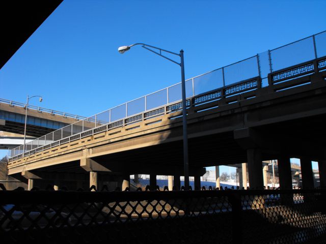
This bridge sits in the shadow of a massive I-96 interchange from the 1970s. This bridge is also located next to a railroad bridge that was built in the same year as this bridge and by the same contractor. The bridge has some uncommon design aspects. A stairway located at the northeast corner of the bridge leads down to the freeway where a small sidewalk is present to provide access to a neighborhood south of the railroad bridge and interchange. This stairway originally had R4 railings as well, but unfortunately they were removed and replaced at some date.
The 2011 reconstruction project will remove the railing as part of a deck replacement. The plans also show that the sidewalk under the bridge will no longer exist, and the space will be used to widen the freeway shoulder.
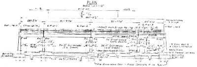
Information About This Bridge From MDOT Bridge PlansThe existing structure is four spans consisting of 28" and 36" prestressed concrete I beams with an 8" reinforced concrete deck with a HMA [Hot Mix Asphalt] overlay. The bridge railing is concrete parapet with railings mounted on top of a brush block on the south side and mounted on the sidewalk on the north side. It was built in 1961, with 44'-0" clear roadway and 54'-9" fascia to fascia. It was designed for HS20-44 loading. |
![]()
Photo Galleries and Videos: Fullerton Avenue Bridge
Bridge Photo-Documentation
Original / Full Size PhotosA collection of overview and detail photos. This gallery offers photos in the highest available resolution and file size in a touch-friendly popup viewer.
Alternatively, Browse Without Using Viewer
![]()
Bridge Photo-Documentation
Mobile Optimized PhotosA collection of overview and detail photos. This gallery features data-friendly, fast-loading photos in a touch-friendly popup viewer.
Alternatively, Browse Without Using Viewer
![]()
Maps and Links: Fullerton Avenue Bridge
Coordinates (Latitude, Longitude):
Search For Additional Bridge Listings:
Bridgehunter.com: View listed bridges within 0.5 miles (0.8 kilometers) of this bridge.
Bridgehunter.com: View listed bridges within 10 miles (16 kilometers) of this bridge.
Additional Maps:
Google Streetview (If Available)
GeoHack (Additional Links and Coordinates)
Apple Maps (Via DuckDuckGo Search)
Apple Maps (Apple devices only)
Android: Open Location In Your Map or GPS App
Flickr Gallery (Find Nearby Photos)
Wikimedia Commons (Find Nearby Photos)
Directions Via Sygic For Android
Directions Via Sygic For iOS and Android Dolphin Browser
USGS National Map (United States Only)
Historical USGS Topo Maps (United States Only)
Historic Aerials (United States Only)
CalTopo Maps (United States Only)


