

View Information About HSR Ratings
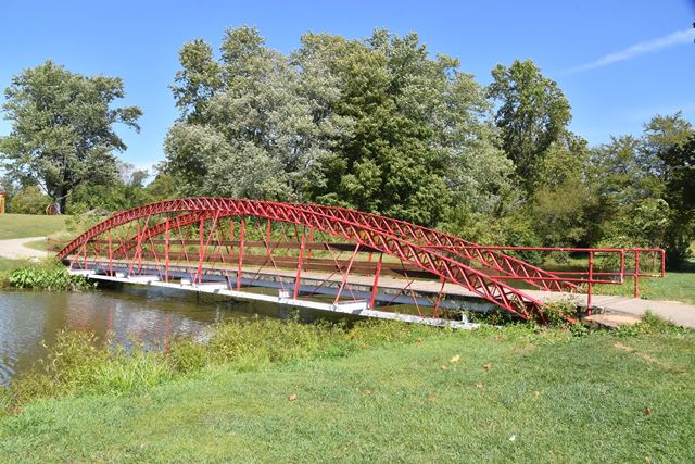
This rare Massillon bowstring truss bridge was relocated and preserved for pedestrian use in a park setting. The bridge was originally on TR-272. This bowstring features sloped vertical members, an unusual feature only found on some Massillon bowstring bridges.
Information and Findings From Ohio's Historic Bridge InventorySetting/Context The bridge carries a pedestrian path/bike trail over a pond in Denver Williams Park in Wilmington. The park is casually landscaped with a pond, picnic area, playground, paved trails, and recreational fields. This is 1 of 2 bowstring trusses on the interconnected system of trails in Wilmington. The other is 14XXXX1, built by the Champion Bridge Co. Physical Description The 1 span, 80'-long, metal bowstring truss was built in 1871 for highway use and relocated to the park for pedestrian use in 1992. The arched upper chord consists of two metal plates bent into an arch shape with a Howe-truss pattern of metal tubes for compression members and vertical rods for tension members. The lower chord is formed by two metal plates with bolted splices. At the bearings, the lower-chord plates wrap around a special cast-iron shoe to form a continuous loop. The tied arch has star-iron verticals and diagonal rods. Floorbeams with outriggers rest directly atop the lower chords. Steel stringers and a wood-plank deck are set atop the floorbeams. Integrity Relocated to park in 1992. Flooring system is 1992. Truss lines are original. Summary of Significance The 1871 Massillon bowstring truss is the former Laymon Road Bridge (former SFN 1448110), which was moved to the park in 1992. Although the flooring system is modern, the truss lines survive intact and continue to convey the technological significance of the rare patented type/design. See the HAER report (OH-15) for more information. The eligible recommendation of the prior inventory remains appropriate. Bowstring trusses are characterized by arched top chords and a trussed or lattice web. They rank among the rarest and most technologically significant of 19th-century metal truss designs since they appeared early in the evolution of iron bridge development and were almost always based on the patents or proprietary designs of bridge builders and engineers. The progenitor of the form was the famed engineer Squire Whipple of New York, who built the first example in 1840 over the Erie Canal at Utica. After the Civil War, Ohio was a center for the development of the bowstring with its concentration of metal bridge-building companies. Companies such Wrought Iron Bridge, Champion Bridge, Massillon Bridge, and King Iron Bridge built their reputations on successful bowstring designs with a dizzying number of variant ways of forming and connecting the truss members. The companies emerged in time to fill the burgeoning demand for an economical, prefabricated bridge for use on American roads. Bowstring trusses thus document this exceptionally inventive and technologically significant period in the development of American metal trusses from the 1860s to early 1880s. The ODOT inventory has identified 22 surviving examples dating from ca. 1864 to 1880 (Phase 1A, 2008). Justification The bridge is one of the 22 extant bowstring truss bridges that survive in the state. Having so many is remarkable, and even though they are "common" based on their numbers, each is an important and irreplaceable record of the development of the metal truss bridge and the ingenuity associated with the Ohio industrial development. The bridge has high significance. Bridge Considered Historic By Survey: Yes |
![]()
![]()
![]()
Coordinates (Latitude, Longitude):
Search For Additional Bridge Listings:
Bridgehunter.com: View listed bridges within 0.5 miles (0.8 kilometers) of this bridge.
Bridgehunter.com: View listed bridges within 10 miles (16 kilometers) of this bridge.
Additional Maps:
Google Streetview (If Available)
GeoHack (Additional Links and Coordinates)
Apple Maps (Via DuckDuckGo Search)
Apple Maps (Apple devices only)
Android: Open Location In Your Map or GPS App
Flickr Gallery (Find Nearby Photos)
Wikimedia Commons (Find Nearby Photos)
Directions Via Sygic For Android
Directions Via Sygic For iOS and Android Dolphin Browser
USGS National Map (United States Only)
Historical USGS Topo Maps (United States Only)
Historic Aerials (United States Only)
CalTopo Maps (United States Only)

© Copyright 2003-2024, HistoricBridges.org. All Rights Reserved. Disclaimer: HistoricBridges.org is a volunteer group of private citizens. HistoricBridges.org is NOT a government agency, does not represent or work with any governmental agencies, nor is it in any way associated with any government agency or any non-profit organization. While we strive for accuracy in our factual content, HistoricBridges.org offers no guarantee of accuracy. Information is provided "as is" without warranty of any kind, either expressed or implied. Information could include technical inaccuracies or errors of omission. Opinions and commentary are the opinions of the respective HistoricBridges.org member who made them and do not necessarily represent the views of anyone else, including any outside photographers whose images may appear on the page in which the commentary appears. HistoricBridges.org does not bear any responsibility for any consequences resulting from the use of this or any other HistoricBridges.org information. Owners and users of bridges have the responsibility of correctly following all applicable laws, rules, and regulations, regardless of any HistoricBridges.org information.
![]()