

View Information About HSR Ratings
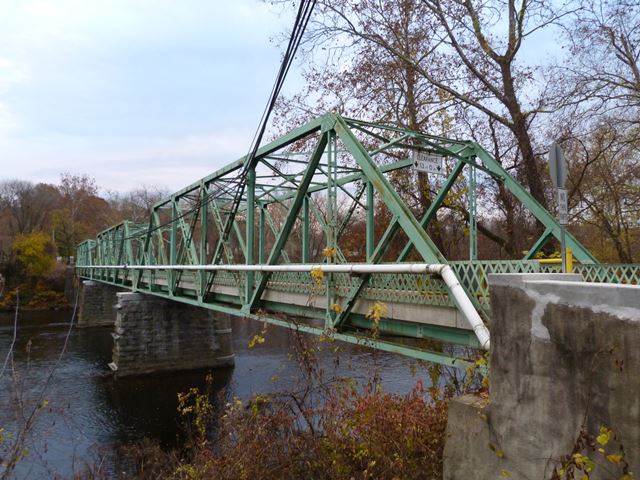
As the Historic Bridge Inventory correctly notes, the 1905 construction date for this bridge given by the National Bridge Inventory is too early for a bridge with its use of rolled beams for the top chord and end post. Regardless of the construction date, the use of the rolled beams on these elements is uncommon. The bridge sits on stone piers likely from the previous bridge.
Information and Findings From Pennsylvania's Historic Bridge InventoryDiscussion of Bridge The 3-span, 357'-long, riveted steel Pratt thru truss bridge is supported on a stone substructure that has been coated in shotcrete. The bridge members are all rolled H or I sections except for the diagonals, which are angles with battens. The BMS lists a date of construction of 1905 but this date is too early for the use of rolled H and I section members, which did not come into common use until the 1920s and 1930s. A more appropriate date based on style is ca. 1935. Lattice railings are set to the inside of the truss lines. The bridge is a late and undistinguished example of its type/design. More than 350 Pratt truss bridges from 1870 to 1956 have been identified in the state with the earliest rivet-connected examples from the 1890s. The bridge is not historically or technologically distinguished by its setting or context. Discussion of Surrounding Area The bridge carries 1 lane of traffic and a sidewalk over a stream in a wooded setting along the Lehigh River. The bridge is one of the entrances to Hugh Moore Park, a green strip bordering the river. The park includes the NR-listed Lehigh Canal, but this is located on the opposite side of the island to the east of the bridge. The bridge is not located over the canal, and it is not historically associated with the canal. Bridge Considered Historic By Survey: No |
![]()
![]()
![]()
Coordinates (Latitude, Longitude):
Search For Additional Bridge Listings:
Bridgehunter.com: View listed bridges within 0.5 miles (0.8 kilometers) of this bridge.
Bridgehunter.com: View listed bridges within 10 miles (16 kilometers) of this bridge.
Additional Maps:
Google Streetview (If Available)
GeoHack (Additional Links and Coordinates)
Apple Maps (Via DuckDuckGo Search)
Apple Maps (Apple devices only)
Android: Open Location In Your Map or GPS App
Flickr Gallery (Find Nearby Photos)
Wikimedia Commons (Find Nearby Photos)
Directions Via Sygic For Android
Directions Via Sygic For iOS and Android Dolphin Browser
USGS National Map (United States Only)
Historical USGS Topo Maps (United States Only)
Historic Aerials (United States Only)
CalTopo Maps (United States Only)

© Copyright 2003-2024, HistoricBridges.org. All Rights Reserved. Disclaimer: HistoricBridges.org is a volunteer group of private citizens. HistoricBridges.org is NOT a government agency, does not represent or work with any governmental agencies, nor is it in any way associated with any government agency or any non-profit organization. While we strive for accuracy in our factual content, HistoricBridges.org offers no guarantee of accuracy. Information is provided "as is" without warranty of any kind, either expressed or implied. Information could include technical inaccuracies or errors of omission. Opinions and commentary are the opinions of the respective HistoricBridges.org member who made them and do not necessarily represent the views of anyone else, including any outside photographers whose images may appear on the page in which the commentary appears. HistoricBridges.org does not bear any responsibility for any consequences resulting from the use of this or any other HistoricBridges.org information. Owners and users of bridges have the responsibility of correctly following all applicable laws, rules, and regulations, regardless of any HistoricBridges.org information.
![]()