We Recommend:
Bach Steel - Experts at historic truss bridge restoration.
La Crosse Bridge
Westbound Spans, Cass Street Bridge

Primary Photographer(s): Nathan Holth
Bridge Documented: August 9, 2013
Cass Street (Westbound US-16 and US-14) Over Mississippi River and Various Streets
La Crosse: La Crosse County, Wisconsin: United States
Metal Cantilever 17 Panel Rivet-Connected Warren Through Truss, Fixed and Approach Spans: Metal 8 Panel Rivet-Connected Warren Deck Truss, Fixed
1940 By Builder/Contractor: Klug and Smith Company of Milwaukee, Wisconsin and Minneapolis Bridge Company of Minneapolis, Minnesota and Engineer/Design: Wisconsin State Highway Commission
1983
475.0 Feet (144.8 Meters)
2,532.3 Feet (771.8 Meters)
30 Feet (9.14 Meters)
3 Main Span(s) and 6 Approach Span(s)
B32030000000000

View Information About HSR Ratings
Bridge Documentation
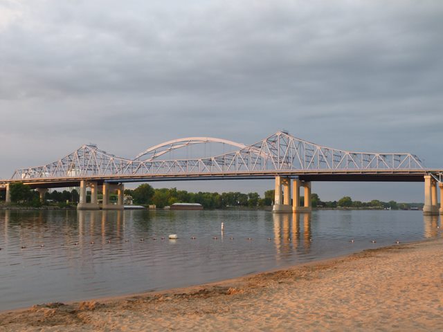
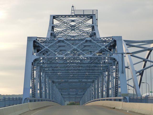
This bridge is an outstanding example of a cantilever through truss bridge. The bridge's main spans include a seven panel suspended truss span as part of the center (channel) span. The design of the cantilever spans overall is traditional, with no particularly unusual details. However, bridges like this are rapidly being demolished and replaced across the country, so this bridge is today historically significant and increasingly rare.
Klug and Smith Company of Milwaukee, Wisconsin was the superstructure contractor while Minneapolis Bridge Company of Minneapolis, Minnesota was the substructure contractor.
In addition to the cantilever truss spans, the bridge also includes an impressive series of deck truss approach spans. Perhaps overlooked by casual viewers, the approach spans are just as interesting as the main spans. The approaches of the bridge are curved. The westernmost deck truss has an unusual design where the bottom chord steps down from the abutment to the pier. The deck truss spans have three truss lines. Another interesting feature is the stairways that are midway along the approach spans at each end of the bridge and allow pedestrians to climb up to the bridge sidewalk. The stairway at the western end (heavily documented in the photo galleries) is more extensive than the eastern one. The western stairway includes a crossover stairway that passes under the deck truss allowing pedestrians to switch which sidewalk they are walking on without walking across the roadway. Incidentally, the walway under the bridge also provides a convenient and interesting view through the bracing of the deck truss spans.
The bridge rests on handsomely designed concrete piers. Original lighting mounts remain on the bridge in the form of riveted steel bars. Another noteworthy observation is that the original riveted sidewalk railings remain on the bridge.
This bridge is an exceedingly rare example of an outstanding preservation solution. Rather than waste money and history demolishing and replacing the historic bridge, to increase the volume that this crossing can serve a second bridge was built next to the historic bridge, forming a one-way couplet of bridges. This is a great way to increase traffic capacity for historic bridges that are too narrow for additional lanes. It also provides redundancy for the crossing. Should one bridge require repairs or need to be closed for some reason, the other bridge can temporarily operate as a two-way bridge. Despite all these benefits, one-way couplets are rarely used, which is unfortunate. The replacement bridge does not overly obstruct the views of the historic bridge, as many nice angles are available north of the historic bridge and the new bridge is located to the south.
This crossing also makes an interesting comparison between historic bridges and modern bridges. The modern bridge's main span is, as modern bridges go, fairly attractive looking, even if it lacks the geometric complexity of a historic bridge. The modern bridge's main span is a steel through arch. But what about the modern bridge's approach spans? It would be hard to describe those as anything other than hideously ugly, composed of huge, plain steel beams. But in contrast, the historic bridge, with its beautiful main spans, also has approach spans composed with attractive deck trusses. With modern bridges, the goal is always simplicity, and that simplicity usually results in bridges that are boring and unattractive. Even when an attempt to produce an attractive modern bridge is made, as with this modern bridge, it is still highly minimalistic.
The previous bridge at this location was a low level crossing, consisting of pin-connected through truss spans including a swing span. One of the spans was destroyed in a vehicle collision in 1935.
View Archived National Bridge Inventory Report - Has Additional Details and Evaluation
View Historical Articles About This Bridge
![]()
Photo Galleries and Videos: La Crosse Bridge
Structure Overview
Original / Full Size PhotosA collection of overview photos that show the bridge as a whole and general areas of the bridge. This gallery offers photos in the highest available resolution and file size in a touch-friendly popup viewer.
Alternatively, Browse Without Using Viewer
![]()
Structure Details
Original / Full Size PhotosA collection of detail photos that document the parts, construction, and condition of the bridge. This gallery offers photos in the highest available resolution and file size in a touch-friendly popup viewer.
Alternatively, Browse Without Using Viewer
![]()
Structure Overview
Mobile Optimized PhotosA collection of overview photos that show the bridge as a whole and general areas of the bridge. This gallery features data-friendly, fast-loading photos in a touch-friendly popup viewer.
Alternatively, Browse Without Using Viewer
![]()
Structure Details
Mobile Optimized PhotosA collection of detail photos that document the parts, construction, and condition of the bridge. This gallery features data-friendly, fast-loading photos in a touch-friendly popup viewer.
Alternatively, Browse Without Using Viewer
![]()
CarCam: Eastbound Crossing
Full Motion VideoNote: The downloadable high quality version of this video (available on the video page) is well worth the download since it offers excellent 1080 HD detail and is vastly more impressive than the compressed streaming video. Streaming video of the bridge. Also includes a higher quality downloadable video for greater clarity or offline viewing.
![]()
CarCam: Westbound Crossing
Full Motion VideoNote: The downloadable high quality version of this video (available on the video page) is well worth the download since it offers excellent 1080 HD detail and is vastly more impressive than the compressed streaming video. Streaming video of the bridge. Also includes a higher quality downloadable video for greater clarity or offline viewing.
![]()
Maps and Links: La Crosse Bridge
Coordinates (Latitude, Longitude):
Search For Additional Bridge Listings:
Bridgehunter.com: View listed bridges within 0.5 miles (0.8 kilometers) of this bridge.
Bridgehunter.com: View listed bridges within 10 miles (16 kilometers) of this bridge.
Additional Maps:
Google Streetview (If Available)
GeoHack (Additional Links and Coordinates)
Apple Maps (Via DuckDuckGo Search)
Apple Maps (Apple devices only)
Android: Open Location In Your Map or GPS App
Flickr Gallery (Find Nearby Photos)
Wikimedia Commons (Find Nearby Photos)
Directions Via Sygic For Android
Directions Via Sygic For iOS and Android Dolphin Browser
USGS National Map (United States Only)
Historical USGS Topo Maps (United States Only)
Historic Aerials (United States Only)
CalTopo Maps (United States Only)


